![]()
 Victory
Parade
Victory
Parade
![]()
Victory
Parade
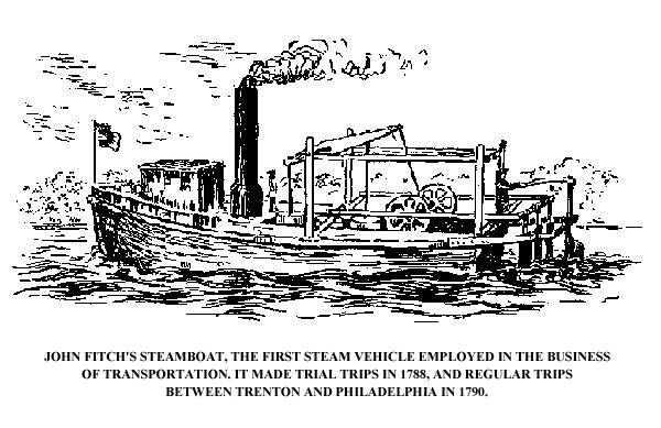
CHAPTER V TransportationBY WILLIAM J. BACKES I. River Navigation IT IS obvious that the growth of any community is inextricably bound up with the growth of its means of transportation. Natural waterways, ferries, bridges, roads, canals, railways - all enter as vital factors into the expansion of a community from a village into a modern industrial center. Trenton’s rise among the cities of New Jersey provides but one more proof of this fundamental economic principle. The great natural highway of commerce and travel in this section is, of course, the Delaware River. When New Jersey and Pennsylvania were unopened territory, wholly in the control of the Indians, the sole means of travel on the river was the canoe. Later came the bateau, a flat-bottomed boat tapering at the ends, in which it was possible to carry heavier and more bulky loads than in light birch-bark canoes. These boats lent themselves to short, quick water hauls, but they were quite ineffective on long trips or in river traffic above the Falls, where the problem of the rapids had to be met. The Delaware has never especially favored transportation over its course. Between Easton and the head of the tidewater at Trenton there are no less than twenty-five rapids or falls, the head of the rapids at Bixler’s Rift (the first of the rapids) being 160 feet above low tide at Trenton. Those who travelled the river in the 1800’s found it difficult to follow the channel not only above the Falls, but below Trenton as well. From Trenton down, the river was dotted with islands, shoals and mud flats; a detritus deposit of many centuries made the channel a treacherous one. GREAT FLOODS ON THE DELAWAREIt was due to the presence of this accumulation of silt that the Delaware often froze during the winter and choked the channel with ice, making any sort of navigation impossible. There were, too, the freshets, which now and again swept down the Delaware, leaving ruin in their wake. The earliest recorded freshet at the Falls was the “great land flood and rupture” of May 29, 1687, which brought about the separation of Vurhultsen’s (Delaware Works) Island from the Pennsylvania mainland at Morrisville. Five years later, on February 27, occurred “the great flood at Delaware falls,” which suddenly descended upon the many Indian families settled in the lowland along the Delaware in this section, sweeping men, homes and cattle away. Between 1692 and the terrible river flood of October 10, 1903, there were 43 freshets in the Delaware, the more disastrous ones occurring on January 8, 1841, and June 6, 1862. These freshets - and now we speak of abnormal rises in the river - came at no particular season of the year. At times we find a series of them occurring yearly over a long period. They made river travel a hazardous thing, and swept away many of the boats, wharves, and other river-front property. EARLY WATER TRAFFICOf the larger craft commonly used in river traffic in the eighteenth century, the wind-propelled vessel was probably the first to appear on the Delaware. The first ship to come some distance up the Delaware was the Shield, which brought Mahlon Stacy, Thomas Lambert, Thomas Potts and others from Hull, England, to Burlington, on December 10, 1678. Most of the larger sail-rigged ships followed the example of the Shield and ventured up the river only as far as Burlington, fearing the shallows in the channel beyond. The few that did come up to Trenton were probably of smaller draught. The shallop and the sloop made the reputation of Lamberton and Bloomsbury (earlier known as Kingsbury) as ports. We find these small sailing vessels on the Delaware in the early days of navigation on that river. The Swedish traveller, Kalm, mentions the “Trenton yachts” in his account of his trip here (1748). The inhabitants of this section, petitioning George II for a corporate charter back in 1746, set out the favorable location of Trenton and stressed the fact that it was at the head of sloop navigation. Located between New York and Philadelphia, at the head of the tide on the Delaware, close to the iron, timber and coal fields of north Jersey, and surrounded by fertile countryside, Trenton enjoyed advantages such as no other small, aspiring town of this section might boast. In the years to come these advantages were to tell heavily in Trenton’s favor and make her one of New Jersey’s greatest industrial and commercial centers. The popularity of the sloop in river traffic grew with every passing year, and is mirrored in its constantly increasing use. These boats were very common in this section after the Revolution, especially during the first three decades of the nineteenth century. They carried the great bulk of the goods shipped between Trenton and Philadelphia; their activity made the fortune of many a family in Bloomsbury and Lamberton, among them those of General John Beatty, Alexander Chambers and Benjamin Fish. It was Robert Lettis Hooper who foresaw the success of the river front south of the creek as a center of transportation. Hooper had large land holdings in that section; in 1759 he set them out in lots for a town. His project, planned in view of the contemplated growing river trade, was described as beginning at Trenton Ferry, being the head of navigation . . . where there is a considerable trade extended from the city of Philadelphia, and great parts of the counties of Hunterdon, Morris, Middlesex, Somerset and Bucks, in Pennsylvania, deliver their produce and rafts of timber, boards, staves, headings, &c., come from 120 miles up the river. 1 1 Pennsylvania Journal, April 31, 1758; New Jersey Archives, Vol. XX, P. 273. During most of the eighteenth, and for at least three decades of the nineteenth century, then, the sloop practically monopolized the upstream trade between Philadelphia and Trenton. Against the current, the value of the raft, the ark and the Durham boat was almost nil. It was in downstream transportation and, what is more important, in transportation on the upper Delaware along a channel filled with falls and rapids, that these boats proved their worth. The raft put in an early appearance on the Delaware; in 1764 we find David Skinner navigating the first one over the 200-mile run extending from Cocheton, 40 miles above Port Jervis, to Philadelphia. This raft was made of six 70-foot pine tree logs, strung on poles, or spindles, which passed through holes bored in the ends of the logs. Upon his arrival in Philadelphia, Skinner was given the freedom of the city and created “Lord High Admiral of the Delaware.” He sold the six logs of his raft for masts. Rafts were used almost exclusively in getting timber from upstate and New York State down to the Philadelphia markets. The construction of these craft was simple; logs or timbers were laid side by side and lashed together; sometimes, as in the case of Skinner’s raft, holes were bored through timbers of approximately the same length and a connecting rod slipped through the holes, thus forming a rigid frame. The passage of the raft from the upper reaches of the Delaware down to Trenton was accomplished in swift and easy fashion. The current carried the raft down through the falls and rapids in short order, the raftsmen using their long poles merely to give a proper direction to the craft and to keep it off the rocks. Below Trenton the matter was not so simple; here the current was slower and the raftsmen had to push on their poles in order to hasten matters along. When the destination was reached, the rafts were taken apart and sold. Sometimes there was, also, a supercargo of barrel staves, hogsheads, and the like, but the practice of sending these down the river on rafts was decidedly risky and therefore uncommon. Inhabitants of this region in the latter part of the eighteenth century and for the first half of the nineteenth were accustomed to the sight of long strings of rafts floating past Trenton on their way downstream. In some strings there were as many as thirty to forty rafts. The raftsmen invariably made an over-night stop in Lamberton, mooring their long files of rafts at the eddy just below the site of the American Bridge Company plant. There were several inns in Lamberton frequented almost exclusively by these rivermen ; of these, the “Red Tavern” (later known as the Delaware Inn and still standing) below Landing Street, and the Raftsman’s Inn, on the site known as “the prairie” south of Cass Street, were the most popular. When the raftsmen rose in the morning to continue their trip downstream, it was a common sight to see the river completely blocked by the rafts which had been moored in it the night before. Rafting in this region reached its height just before 1845. In the spring of 1828 as many as one thousand rafts, containing fifty million feet of lumber, passed by Trenton. A great percentage of this footage was hemlock. The rafts were usually floated downstream during the four weeks of the spring freshet season and in the autumn. The great problem of the raftsmen was, of course, to avoid the numerous shoals below Trenton and to gain the channel in which the swiftest current flowed. At the height of the rafting era in the ‘40’s, the rafts were usually towed down the river in long strings by the Lenox Towing Company, a firm managed by the Lenoxes of Lamberton who were well known among the river people of that time. The Lenox family also owned a wharf and storehouse just above Lalor Street. The rapid depletion of the forests on both sides of the upper Delaware, and the growth of railroad transportation facilities, put an end to the practice of rafting lumber to the Philadelphia markets. The raft had been an ingenious device whereby lumber practically transported itself from one place to another, and when the supply of timber waned the raft, too, ceased to be. Another river conveyance in common use on the Delaware at one time was the so-called “ark.” Like the raft, it was invented to fill a special need - to carry the anthracite coal, which had just been discovered in the Lehigh fields, to the markets on the lower Delaware. The first ark, an experimental affair, was built by William Trumbull in 1806 at Lausanne, Pa. In that year it carried ten tons of coal down the river to Philadelphia, but when it arrived there, it was found that there was hardly any demand for the fuel. A good deal of the cargo was thrown away into the streets. It was not until 1814 that transportation of coal in arks began in a practical way. The usual ark was a rectangular box, often pointed at one end, and made of heavy pine planks, 16 feet long, 2 feet wide, and half an inch thick, planed to a fair smoothness. Like the raft, it too was guided by means of long oars, or poles, placed at either end. Its dimensions were, roughly, 16 to 18 feet wide and 20 to 25 feet long. The arks, singly or in strings of eight or ten, were guided down the Lehigh and into the Delaware, past Trenton to Philadelphia. It was a common occurrence for two or three arks out of every string to have their bottoms staved in before they had even reached the mouth of the Lehigh. Yet, despite frequent loss of both arks and cargos, coal operators found the ark the most economical way of carrying their coal to market. On arriving at Trenton, or Philadelphia, the coal, ark and all were sold; the coal usually brought two dollars a ton and the ark was thrown into the bargain. Shipments by ark continued until the opening of the Lehigh and Delaware Division Canals in the ‘30’s; after that, coal was shipped in canal boats over the canal route. THE DURHAM BOATSThe Durham boat, 2 known to history because it figured so largely in Washington’s Christmas Night crossing of the Delaware, was the first of the tide-propelled freight craft to appear on the river. The boat was used by the Durham Iron Company as early as 1727, to transport the product of the Durham forges to Trenton and Philadelphia and to bring back necessary provisions and supplies. The usual Durham boat was flat-bottomed and had vertical sides which ran parallel to each other up to a point 12 or 14 feet from the end, where they began to taper. It was constructed of sturdy inch-and-a-quarter oak planks, and measured 60 feet long, 8 feet wide, and 42 inches deep. Its draft was 3 1/2 inches when light and 28 inches loaded; it could carry 150 barrels of flour or 600 bushels of corn. Downstream it was possible to load it with as much as 17 tons, but 2 tons was the limit upstream. It took three men to direct its progress. In going downstream they made every use of the current and employed their 12- to 18-foot “setting-poles,” shod with iron, merely for steering. Going upstream, the poles were used for propelling the boat, the men walking back and forth on “walking boards” built on the sides of the Durham boat, the better to gain a maximum effect from the application of their strength at the ends of the poles. 2 John A. Anderson, Navigation on the Upper Delaware, p. 16. The Durham boat was used extensively in carrying flour, whiskey, meat and iron products from Trenton and points north along the river to the markets lower down on the Delaware. The men who guided the heavy boats downstream made Trenton, or more specifically, Lamberton, their main stopping place. WHARVES AND WAREHOUSESThe wharves and warehouses used in local transportation were located almost exclusively in Bloomsbury and Lamberton. References to them are so few that one cannot hope to reconstruct the scene of a century ago with any degree of completeness. The more ancient landings were situated in Lamberton. Of the first two wharves to be built in Bloomsbury, one was located about 400 feet south of the lower bridge site and the other on the site of the municipal terminals at the foot of Ferry Street. The first-mentioned landing was built in 1803 by Alexander Chambers, to whom the historian, Hall, refers as the first man to establish Bloomsbury as a port for sloops. 3 Chambers owned and operated several sloops on the route between Trenton and Philadelphia. The wharf near the foot of Ferry Street seems to have been the “steamboat landing” referred to in many advertisements of the time. It was probably built about 1809, to accommodate the steamboat Phoenix. 3 Hall, History of the Presbyterian Church in Trenton, N.J. (rev. ed.), p. 96. Adjoining the steamboat wharf and running north for 200 feet along the river front and for the same distance on Bloomsbury Street in the rear, was a lot owned by J. R. Smith and E. Evans, on which there was a wharf. It was probably built after the steamboat wharf was erected. In 1833 it was owned by Smith alone. To the north of it was the wharf owned by Benjamin Fish, who was a prominent figure in river transportation in the early decades of the last century. To this landing came his three sloops. His warehouse was located in the rear of the wharf, on the lot next to the southwest corner of what was Ferry and Fair (now Bloomsbury) Streets. Fish kept a store near his wharf where he took orders for the stove coal which the arks brought to his wharf direct from the Lehigh fields. This store, with its goods and groceries, was offered for sale in 1823. 4 Abraham Mershon also had a landing in this section, a few hundred feet north of the Trenton Ferry landing at the foot of Ferry Street. There were other landings nearby, but their owners and the years of their erection are unknown. 4 Federalist, June 16, 1823. The first mention of a wharf in Lamberton is found in an advertisement 5 published in 1764. There was a storehouse attached to the landing. William Richards had a landing in Lamberton near the foot of Landing Street during the Revolution; from it ran his schooner, the Lamberton Packet, which carried passengers and goods to and from Philadelphia. 6 Very early in the 1800’s Philip H. Howell built a wharf in Lamberton near the steamboat landing. The wharf, along with his lumberyard, house and stores, was advertised to let in 1819. 7 Howell’s warehouse was opposite Benjamin Fish’s storehouse on Fair Street. Several other wharves existed below the steamboat landing. Among them may be noted the two docks at the foot of Lalor Street, one immediately below the line of the street and the other just to the north of it. There was a wharf situated on the river bank several hundred yards above the latter landing. At one time it belonged to the Lenox family of Lamberton, along with a warehouse of fair size. Both wharf and warehouse were destroyed in the ice freshet of 1852. Recent excavations have unearthed evidences of old warehouses and docks below Lalor Street, but who owned them is unknown. Elijah Bond had a small landing on his tract below the present site of Riverview cemetery, in the middle of the eighteenth century. 5 The Pennsylvania Journal, May 10, 1764; New Jersey Archives, Vol. XXIV, p. 361. 6 New Jersey Gazette, September 9, 1778; New Jersey Archives, 2nd Ser., Vol. II, p. 414. 7 Federalist, January 19, 1818. The only record of a wharf north of the Falls is that referring to the one owned and operated by John Rutherford, the owner of Beatty’s ferry, of which further mention will soon be made. In an advertisement appearing in 1806, 8 Rutherford speaks of his large wharf as the only one above Trenton Falls for the Easton and Durham boats trading there. In an earlier day there were wharves in Little River, the stream which flowed between Gravel Island and the mainland. They were situated along the present-day Mahlon Stacy Wall, back of the State House. 8 ibid., September 29, 1806. STEAM NAVIGATIONThe eighteenth century, then, depended on the tide, the wind, and human energy to move its boats. The century was almost done when John Fitch came along with the first practical application of steam to the moving of a vessel. Fitch’s invention preceded Fulton’s Clermont by a round score of years. It is not until recently that he has received due credit for the part he played in the invention of the steamboat. Fitch was born in what is now South Windsor, Conn., on January 21, 1743 (O.S.). As a boy he was apprenticed to a watchmaker; from this he turned to following the sea, but it, too, failed to hold him for long. Back home, he stumbled into an unfortunate marriage, and this, coupled with his father’s tyranny, drove him into leaving Connecticut forever. Fitch wandered down to Trenton in 1769, and was taken in as an apprentice by Matthew Clunn, a tinsmith and maker of brass buttons. This was in May. During the summer he worked under James Wilson at silversmithing, but in September he took to peddling brass and silver buttons around the neighboring countryside. As a member of the Continental army during the early years of the Revolution, Fitch managed a gun shop here in which he employed as many as 60 men in turning out work for the New Jersey troops. When the British came into this section, Fitch, along with many Trentonians, crossed the river into Bucks County. In 1780, and in the three or four years following, he made several trips into the territory now known as Kentucky; on one of these excursions he was captured by the Indians, turned over to the British, taken to Canada, and finally sent back to New York in an exchange of prisoners. It was after his return home to Bucks County that he conceived the idea of applying steam to navigation. The date is usually indicated as April 1785. By August he was exhibiting his first boat - a small, crude affair, propelled by paddle wheels run by a tiny engine - to the provosts of the University of Pennsylvania and to the authorities at Princeton College. Later in the month he petitioned Congress for aid in completing his invention, “adapted especially for the waters of the Mississippi,” but the application was never reported out of committee. JOHN FITCH’S STEAMBOATIn September Fitch rigged up another model, fitted with long paddles on either side, moving on two endless chains running from stem to stern. Several weeks later he petitioned the Virginia Legislature for assistance, and then the Pennsylvania and Maryland Legislatures. None gave him aid. Perhaps the most bitter disappointment experienced by Fitch at this time came at the hands of Benjamin Franklin, the dean of American science, or natural philosophy, as it was then called. Most of the evidence comes from Fitch. He writes that he approached Benjamin Franklin for a certificate testifying to the merits of his invention, and though Franklin praised his endeavor, he evaded giving him a certificate. Instead, he made Fitch an offer of charity, which Fitch refused. In this connection, it is interesting to note a letter written by Franklin from Philadelphia in 1788: We have no philosophical news here at present, except that a boat, moved by a steam-engine, rows itself against tide in our river, and it is apprehended that the construction may be so simplified and improved as to be generally useful. Franklin, it would seem then, was impressed with the possibility of Fitch’s invention, but not with the crude plan which he presented to him. There were refinements to be made, plans to be modified, before he could testify to the practical and efficient qualities of the boat. It was shortly after this meeting with Franklin that the New Jersey Legislature granted Fitch the exclusive franchise for 14 years . . . of constructing, making, using and employing, or navigating, all and every species or kind of boats, or water craft, which might be urged or impelled by force of fire or steam, in all the creeks, rivers, etc., within the territory of this State. Stacy Potts, Isaac Smith, Robert Pearson, Jr., Samuel Tucker, Abraham Hunt, Rensselaer Williams, John and Charles Clunn, and others of Trenton, lent their names to the petition for the franchise. With this encouragement, Fitch went about the organizing of a company. Stacy Potts was among those who subscribed to the initial fund of $300. The builder of the boat, Henry Voight, of Philadelphia, received stock of the company for his work. The boat was a small one, with an engine possessing a single cylinder of 3-inch bore. The first trials on the Delaware, held July 20, 1786, were unsuccessful. Fitch had experimented with several methods of propelling the boat; the plan that succeeded was that in which the side paddles were moved by cranks worked by an engine. The first boat in America to be propelled successfully by steam moved on the Delaware on July 27, 1786. It was an enthusiastic Fitch who wrote to Stacy Potts from Philadelphia the next day. “We have tried every part, and reduced it to as certain a thing as can be, that we shall not come short of ten miles per hour, if not twelve or fourteen. I will say fourteen in theory and twelve in practice.” Fitch’s fond belief never materialized, even in the most efficient of his models. His first successful boat made several trips on the river near Philadelphia in the autumn of 1786.
In need of further funds, Fitch applied to the Pennsylvania Legislature the same year, but he was unsuccessful. Delaware, however, confirmed his right to his invention. In February 1787, Fitch’s shareholders agreed to advance additional capital for the building of a 45-foot vessel; equipped with an engine containing a single 12-inch cylinder. Lacking skilled workmen, Fitch had to depend upon fumbling blacksmiths in the manufacture of this new engine. Their faulty work was the cause of many accidents and delays. Finally the boat moved on the river in full view of practically the entire Continental Convention (August 22, 1787). Fitch thought it an appropriate time for once again petitioning the Continental Congress for aid; this time the bill was reported out of committee, but died on the floor of the House. The new boat traversed the Philadelphia-Burlington route for the first time in July 1788. At the end of the run, the boiler burst and the ship had to be floated back to Philadelphia. A new boiler was installed and on October 16 Fitch ran his steamboat, on which were a company of prominent guests, up the Delaware to Burlington, and then on to Trenton, returning to Philadelphia the same day. In order to cut down the time on the Philadelphia-Trenton run to five hours, an auxiliary company was formed to finance the building of a new 18-inch cylinder engine. During 1789 the boat made several trips to Burlington and Trenton, but regular service could not be maintained because of the unreliable machinery. This steamboat was the last of Fitch’s boats and the most successful one. It made its last trips on the Delaware in 1790. An advertisement which appeared on June 14 of that year informed the public that: The Steam Boat Is now ready to take Passengers, and is intended to set off from Arch Street Ferry in Philadelphia every Monday, Wednesday and Friday, for Burlington and Trenton, to return on Tuesdays, Thursdays and .Saturdays. - Price for Passengers, 2/6 to Burlington and Bristol, 3/9 to Bordentown, 5/ to Trenton. This craft was the first steam vessel anywhere to be employed in the business of transporting passengers and freight. The boat made more or less regular trips up and down the river during the summer and fall of 1790. Those who travelled on it placed its speed at eight miles an hour. 9 9 Watson’s Annals, Vol. II, p. 446. Congress granted Fitch letters patent on his invention in April 1791. When Fitch visited France, Louis XVI granted him a patent, but the French Revolution put an end to whatever use Fitch might have intended to make of this right. Fitch’s plans, left behind in France, are commonly supposed to have furnished Fulton with ideas for his successful Clermont. Tired and embittered, Fitch withdrew from a world that had shown him little kindness. He settled on his tract at Bardstown, Ky. There he died on July 2, 1798, the circumstances of his death pointing to suicide. His grave was soon forgotten, but in recent years the John Fitch Chapter of the Daughters of the American Revolution found it again and removed Fitch’s ashes to a new grave in front of the Bardstown Court House. The grave is marked with a monument. Fitch’s genius is also commemorated by a bronze tablet in the Hartford, Conn., capitol building. John Fitch Way and the John Fitch memorial boulder and tablet are Trenton’s tribute to the inventor. John Fitch Way runs from the municipal wharf along the river front as far as Assunpink Creek. It was formerly Commercial Avenue, but the name was changed by an ordinance passed early in 1921. The Fitch boulder was dredged from the river and set up at the lower end of John Fitch Way, near the municipal wharf. After an appropriate bronze tablet had been attached, it was dedicated on November 30, 1921. OTHER EARLY STEAMBOATSThe work of Fitch and Rumsey and Fulton paved the way for the practical use of steam in river transportation. In 1809 we find a steamboat leaving Beatty’s wharf in Bloomsbury for Philadelphia, 10 every Tuesday, Thursday and Saturday, and returning from that place the next day. 11 This steamboat was the famous Phoenix, built by John Stevens at Hoboken in 1808 for travel on New York waters. Fulton obtained an injunction against Stevens on the ground that his project would trespass upon Fulton’s exclusive right to the use of the waters of New York State. Stevens thereupon sent the Phoenix from Hoboken down to Philadelphia under her own steam in 1808. A storm came up, the pilot boat became separated from the steamboat, and the Phoenix, long overdue at Philadelphia, was given up for lost. The Phoenix, however, rode out the storm and ended up in Barnegat Bay, from which place she proceeded on to Philadelphia. She was the first steamboat ever to travel upon any ocean. 10 Federalist, August 7, 1809. 11 ibid., May 11, 1812. The Phoenix belonged to the Swiftsure Line and was in the command of Captain Degraw. Her running time between here and Philadelphia was three hours running with the stream and five hours against it. The Phoenix was on this route until 1821, when she grounded on the mud flats at Kensington. The presence of steamboats on the Delaware did not affect the extensive sloop trade to any marked degree at first. It was not until a decade later - about 1820 - that their competition began to tell. In 1810 the sloop Factor set out regularly from its Bloomsbury landing every Monday during the milder season, and returned from Philadelphia on Thursdays. 12 Captain McKean was in charge. The sloop Traveller, too, maintained a regular packet service weekly on the same route. 13 Like the Factor, it carried both freight and passengers. Its wharf was the “upper Bloomsbury landing,” which Alexander Chambers had built back in 1803. This landing was also known as Beatty’s landing and Bloomsbury landing, and was the most important landing in Bloomsbury. In 1812 we find the sloop Try-All, under the command of Captain Johnston, maintaining a regular packet service to Philadelphia. This sloop had once been owned by Alexander Chambers and General Beatty, 14 but the partnership was dissolved in 1812 and Chambers became sole owner. Chambers’ assignees advertised his landing, the Try-All, his storehouse and lot of ground along the Delaware, for sale in 1817. 15 12 Federalist, May 10, 1810. 13 ibid., July 8, 1812. 14 ibid., March 9, 1812. 15 ibid., September 15, 1817. The Trenton sloops played an important part in rendering the British blockade at New York and Philadelphia during the War of 1812 for nought. These sloops transported all sorts of military supplies from Philadelphia to Trenton, where they were loaded on wagons and taken to New Brunswick, there to be carried forward to New York. From 1810 to 1820 there were several steamboats on the Delaware between Philadelphia and Bordentown, among them the Philadelphia. This boat was in the command of Captain Jenkins of the Union Line, and it travelled the Philadelphia-Bristol route. Stages met the boat at the latter place and carried the passengers forward to Trenton and New Brunswick. Boats stopping at Burlington or Bordentown were also met by stages at these places. Nathaniel Shuff of Bloomsbury was the proprietor of one of these stage lines. His stage carried the passengers to Trenton and points as far beyond as New York. 16 16 ibid., August 6, 1810. The Philadelphia was also known as Old Sal, probably because of the grotesque female figurehead which she carried on her bow. In 1815 we find her on the Trenton route, running from Philadelphia every Monday, Wednesday and Friday at 8 a.m. and returning to Trenton on the next day. 17 The Philadelphia was on the Trenton route as early as 1814 and continued to make regular trips during the late spring, summer and autumn seasons until at least 1825. 18 17 ibid., April 17, 1815. 18 ibid., August 9, 1824. AN ERA OF KEEN RIVALRYWith the ‘20’s a keen rivalry arose between the steamboat lines on the river, particularly between the Union Line and the Citizens’ Line. In the decade before, the Citizens’ Line had built the New York for service on the lower Delaware. The Union Line countered with the New Philadelphia, which it put on the same route in 1815. The next move of the Citizens’ Line was to build the Pennsylvania, about 1825, which ran from Philadelphia to Bordentown. The Union Line answered the challenge with the Trenton, running between Philadelphia and Trenton. James A. Stevens, owner of the Philadelphia, did not permit this competition to pass unnoticed; he put the Franklin into the Trenton-Philadelphia service and lowered the fare to one dollar each way. 19 The next year another firm put the Congress on the same route, making trips daily, except on Sundays. Carriages met the boat at the Bloomsbury wharf and carried the passengers up to the Trenton hotels gratis. This service was imitated by all the boats - the Stevens-owned Philadelphia and Franklin, and the Trenton of the Union Line. Philadelphia-bound passengers were called for at their hotels on the morning of their departure and carried to the wharves free of charge. The Union Line stages were especially efficient in this service; those wishing to be carried to the Trenton or the Baltimore (which was put into service in 1827) on the morrow had but to leave their names at Joseph Bispham’s Trenton House, or at Aaron O. Shuff’s Steamboat Hotel near the wharf in Bloomsbury, or at the Union Line office proper, which was located opposite the Trenton House on Warren Street, several doors below the Rising Sun Hotel. 20 In the period when competition was great (1825-30) the Union Line hacks called for the passengers at their homes and hotels, but in 1832, when the line was having things pretty much its own way on the river, the stages went direct from the Union Line office to the wharf, taking up only such passengers as presented themselves at the office. 21 19 ibid., August 9, 1824. 20 ibid., March 19, 1827. 21 New Jersey Gazette, October 20, 1832. The Union Line Company, of which Benjamin Fish was the president, also carried passengers in its stages between the steamboat landing and Princeton, New Brunswick and New York, at fixed rates. A. P. Atkinson was the Trenton agent for the Union Line coaches. After the Camden and Amboy Railroad and Transportation Company was incorporated, the various lines on the river, including the Union, Citizens’ and Dispatch, were merged into the larger company. This company took over the Union Line Company’s stages and Trenton hack service. Many of the sloop lines also found their way into the hands of this corporation. Before this huge merging process took place there were a few changes in the list of river steamers. In 1827 came the Union Line Baltimore, 22 mentioned above, and this was displaced in a few months by the steamer Burlington. 23 The Union Line added the Marco Bozzaris to its Philadelphia-Trenton route in 1828, 24 and in 1832 the line put the Robert Morris into the same service. 25 The Emerald, owned by the Dispatch Line, which had the backing of Cornelius Vanderbilt, is supposed to have been in the Trenton service at this time, but there is no corroborating record. 22 Federalist, March 19, 1827. 23 ibid., July 2, 1827. 24 ibid., August 11, 1828. 25 New Jersey Gazette, October 20, 1832. In May 1841 the Major Barnet, a 110-foot boat, licensed to carry passengers, came to Trenton. Its owners intended it for the transportation of passengers and goods between Lambertville and Easton. The problem, of course, was to run the steamboat through the falls. Several unsuccessful attempts were made in the summer of 1841, but it was not until November that the Major Barnet achieved the upper Delaware. John H. Morris, a riverman, found the 22 inches of water necessary for navigating the boat, and steered it up through Trenton Falls to the foot of Wells Falls without difficulty. At Wells Falls it was necessary to use full steam, two men with poles, and men tugging at a rope which had been fastened to the rocks at the entrance to the falls, before the boat got through. It took the Major Barnet ten minutes to travel 110 feet, but it was done, and the boat was the first steamboat on the upper Delaware. She was active in the Easton trade, but the railroad put her out of business.26 26 Trenton Times-Advertiser, March 28, 1909. In 1840 the Hornet appeared on the Delaware and plied between Trenton and Philadelphia. The fare was 25c and persons leaving their name at the Rising Sun Hotel the night before would be called for by the omnibus the next morning. Abner Mershon’s Proprietor was on the same route in 1843, but ran only a short time. On May 7, 1849, the Edwin Forrest made her first trip to Trenton. She ran daily except in winter between Trenton and Philadelphia for many years, being obliged to regulate her departure by the tide because of the shoals at Perriwig Island below. Her wharf was in the rear of Bloomsbury House. The boat was owned by Joseph and Benjamin McMackin. As a matter of fact there were two Edwin Forrests, the first one a wooden steam-boat and the second, which began to run in 1865, being of iron construction. The second one carried great quantities of freight and was well patronized by passengers, making the river trip for business or pleasure. Captain Joseph H. McIntyre succeeded Captain Benjamin McMackin and was on the bridge up to the time she was retired in 1895. Considering that there was an Edwin Forrest in service for forty-seven years, it is not surprising that many local memories are enshrined about the name. All freight brought to Trenton by the sloops and steamboats during the first half of the century was transferred to heavy wagons and hauled to New Brunswick, where it was placed on ships to be carried to New York. Some of the goods were kept, for the time being, in the many warehouses along the river. The steamboats which covered the Trenton-Philadelphia route in a later day included the Twilight, City of Trenton (which finally blew up because of a boiler explosion), Pokonoket, Burlington, Columbia and John A. Warner. During the 1910 decade, the Trenton Transportation Company operated the Queen Anne and the Dolphin. The landing for these boats was just below Lalor Street, and adjoining it was a warehouse. TRENTON AS A PORT OF ENTRYTrenton was created a port of entry by an Act of Congress, just before the Civil War. The official name was “Port of Trenton, District of Burlington,” and a Collector of Customs was appointed whose duty it was to register all vessels plying the Delaware River or the Delaware and Raritan Canal, between Trenton and Philadelphia. He also had to certify shipments of merchandise bought in foreign ports, and the license papers of every ship operating over the route just mentioned. Those who held the office of Collector of Customs were Captain Harry Ashmore, William Ashmore and Captain John A. Wilson. The office was later transferred to Camden and Philadelphia. The ever-present obstacle to Trenton’s becoming a large port was the lack of a channel of sufficient depth to insure the safety of vessels venturing up the river from Philadelphia. The present mayor of Trenton, Frederick W. Donnelly, has been largely instrumental in bringing about the necessary deepening of the channel. DEEPENING THE CHANNELThere had been previous attempts to have the Delaware cleared. By Act of General Assembly, passed December 21, 1771, a commission was appointed to receive subscriptions for clearing the river above Trenton Falls as far as Easton. The commissioners had power to clear, open, enlarge, straighten or deepen the river. The work was subcontracted out, Major Robert Hoops actually doing the work near Trenton Falls and completing the task in 1791. It was in the period immediately preceding the coming of the railroad that a real interest was manifested in improving the Delaware. In 1811 the inhabitants of Burlington and Hunterdon petitioned the Legislature relative to removing the sandbar on Perriwig Island. The committee of the House was averse both to recommending a grant from the Treasury for financing the work or permitting a lottery to be raised locally. It did, however, recommend that the petitioners be allowed to present a bill which would authorize them to go upon Perriwig Island and remove the obstruction themselves. Nothing, however, was done in the matter. On November 13, 1809, the Legislature had passed an Act authorizing the building of a lock in the river at Trenton, for the improvement of navigation. The purpose of this lock is indicated by the text of a like Act, passed February 9, 1815, authorizing Daniel W. Coxe, Samuel Wright, Jr., and Peter T. Smith to build a wing dam in the river opposite Market Street, “to have a lock in the same, where it crossed that part of the river on the east side of Yard’s Island, of such size and dimensions that Durham boats of the largest size and other craft may pass up and through the same with ease and safety; the lock to be not less than twenty feet wide.” The work of deepening the channel from Philadelphia to Trenton was not started until the present century. On June 25, 1910, the federal government adopted the project for a channel 12 feet deep at mean low water, and 200 feet wide, from Alleghany Avenue, Philadelphia, to Lalor Street, Trenton, and for the construction of dikes at Biles Island, Bordentown, and Mud Island. The work was completed, except for the Mud Island dike, in 1913, at the cost of $311,000. Annual maintenance was estimated at $20,000. The greatest amount of dredging by far was done in the channel between Trenton and Bordentown. The project for deepening the channel above Lalor Street as far as the railroad bridge was adopted by the federal government on July 25, 1912. The plan called for a 12-foot channel, 200 feet wide, and a turning basin at the site of the municipal wharf, 300 feet wide and 400 feet long. By the River and Harbor Act of June 5, 1920, Congress combined this project and the one of 1910 into a single project. Work on the municipal dock was begun May 6, 1915; the upper section of the united project, including the excavation of approximately 20,000 cubic yards of rock, was completed August 1921. The estimated cost of the entire improvement is $825,000, with an estimated cost of maintenance of $25,000 annually. The wharves, warehouse shed and other property at the municipal wharf alone cost $280,000, while the additional land for John Fitch Way and contemplated future developments brought the total up to $365,000. The 12-foot channel has made Trenton an important commercial center, since it enables larger ships to come all the way up the river. The improvement of the channel, however, will continue. The River and Harbor Act of March 3, 1925, adopted a new project providing for an increased channel depth of 20 feet at mean low water between Philadelphia and the Trenton municipal wharf, having a width of 200 to 300 feet. The estimated cost will be $1,326,000. This project is being urged by the Atlantic Deeper Waterways Association, which was organized in Philadelphia in 1907 and whose main object is the creation of an intra-coastal canal, extending from New England to Florida. In 1928, vessels could navigate inland from Trenton to Beaufort, N.C., over a 12-foot channel. A waterway across New Jersey from Morgan, on Raritan Bay, to the Delaware River just above Bordentown will complete the inland chain from Boston to Beaufort. Further mention of this waterway will be made under the discussion of canals. At present the Philadelphia-Trenton-Norfolk Steamboat Company is operating barges and tugs for carrying freight, as well as the passenger boat William Penn which runs during the summer, over the 12-foot channel. Sea-going barges of 1000-ton capacity frequently find their way up to Trenton. The municipal wharf and warehouses were dedicated on May 11, 1919. The dock is 200 feet wide and extends inshore 250 feet. The steel warehouse shed, whose flat roof is used as a recreation center in the summer-time, is located at the upper end of the dock and measures 115 feet by 195 feet. II. Roads and HighwaysAT THE time that the Shield came up the Delaware, there were no roads in this vicinity. Only paths led from one Indian settlement to another. The path beginning at “Inian’s Ferry” on the Raritan and leading to the “Falls of the Delaware” was the forerunner of the New Brunswick-Trenton road. This path is supposed to have been opened by the Dutch early in the seventeenth century. When William Edmundson, travelling minister of the Society of Friends, traversed this route in 1675 on his way southward, he found only a narrow path leading to the Falls. Of his trip he wrote: We travelled that Day, and saw no tame creature, at Night we kindled a fire in the Wilderness and lay by it, as we used to do in such Journies; next day, about nine in the Morning, by the good Hand of God, we came well by the Falls. 27 27
A Journal of the Life, Travels, Sufferings, etc., of
William Edmundson, 2nd ed., p. 107. On the road from Trenton to Brunswick I never saw any place in America, the towns excepted, so well peopled. The book of minutes of the Supreme Court (1681-1709) provides us with interesting notes on the growth of the system of roads in this vicinity. The first overseers of highways in the first tenth were appointed May 22, 1683, and were John Woolston and John Shinn. February 20, 1690, saw the choosing of an overseer for the highways of Nottingham Township for the first time. John Lambert was the first overseer for Nottingham. The duties of this office must have increased by reason of the laying out of more roads, for in February 1692-93, two overseers were appointed to attend the roads in that township. THE BURLINGTON ROADThe grand jury of Burlington “presented” that County for not laying out and taking care of a lawful highway “where they are wanted - to ye ffalls,” in May 1692. Here is the earliest mention of a road leading from Trenton to Burlington. In 1693, the court ordered Nottingham and Chesterfield to lay out a road to East Jersey. Where this road was, or whether it was ever laid out, is unknown. At the February 1696-97 sessions of the Burlington County Court, Maidenhead Township was formed from that part of Nottingham Township lying north of the Assunpink. The next year the court ordered the constable of Maidenhead to call “twelve sufficient men” to lay out the King’s Highway from a point on the Province line to the Assunpink. This minute in the court book is the first mention one finds of the path from “Inian’s Ferry” to the Falls being designated as the King’s Highway. The route of the present Lincoln Highway follows, approximately, that of the old King’s Highway, which ran down to the Assunpink along the present line of Broad Street. The constable returned the following description of the highway: Beginning on ye sd line at Yorke old Roade at ye Corner of Joseph Worth’s land, thence to ye eight mile Runne thence through Jonathan Daviss his land Improved & Inclosed, thence over ye six mile Runn through Theophilus Philips land, thence over several mens lands and over Thomas Smiths land to ye five mile Runne thence over Mahlon Stacys land to Assanpink Creeke neare ye mill of Mahlon Stacy. THE MAIDENHEAD ROADDissatisfaction was widespread in Maidenhead in 1698 because of the existence of two roads running from the town down to the Assunpink. Accordingly, a precept was directed by the court to the constable to call the inhabitants together and put the matter to a vote, so that the “Road which shall be pitcht upon & approved of by the majority of votes shall be the Establisht road.” Maidenhead Road, as it existed in 1699, is given by the following abstract to be found in the Supreme Court minutes: Begins at the partition line; by marked trees to 8 mile run; to a white oak in land of Johannes Lawrence; by marked trees to a white oak before Ralph Hunts door by the run; by marked trees to bridge over 6 mile run to Robt Lannings Land; thence direct through Wm Acres land and Jasper Smiths land and Thos Smiths land to 5 mile run to a hiceree tree; by Samuell Mathews and Saml Stacy to Shabakunck Bridge; thence through Mahlon Stacy to mill as trees direct. Mention is again made of the road leading from Burlington to the Assunpink in the Supreme Court minutes under date of the 19th of the twelfth month (February), 1702. On that day the inhabitants of Nottingham presented the following petition to the justices sitting at Burlington: Whereas there has been for more than twenty years past a Highway Leading from the ffalls towards Burlington over Croswick Creeke through the plantation now of Samll Overton which Much Shortens the journey as well as for the Convenancy of Travelers as also for ye Inhabitants of the township of Nottingham and Whereupon the Inhabitants at their Last towne meeting Were Unanimously Concenting and did there all Concent and agree (Excepting the said Samll Overton) that the same should be so Continued and remaine as a free Bridle Stye and way for travelers and therefore humbly prays the Concurrence of the Court in Confirmation of the same. – Signed in Behalfe of the Town p. Willm Emley Clerk. Whereupon the Court Orders that it shall continue a Bridle Way. The description of the Burlington Road as a "Bridle Way" incidentally indicates what most of the "roads" of that time actually were, - paths wide enough to permit of the passage of a man on horseback or a packhorse. These "roads" continued to be nothing more than bridle ways until 1716, when the Assembly passed an Act for the "Further establishment of Fees, and Ferriages." It was not until almost 1800 that they were to become two-, four- and six-rod-wide roads. The abstract set out above shows that the Burlington “Bridle Way” had existed as far back as 1682. In 1700, then, but two land routes of any importance existed in this section: the King’s Highway and the path leading to Burlington. The King’s Highway was variously known as the Old Yorke Road and the road to Maidenhead. The road to Burlington was sometimes referred to as the road to Crosswicks. THE PENNINGTON ROADThe proprietors, in order to encourage the building of roads throughout the Province, had been very liberal in their concessions. Thus, in 1676 the West Jersey proprietors agreed that: We do also grant convenient Portions of Land for Highways, and for Streets, not under one Hundred Foot in Breadth, in Cities, Towns and Villages. And for Wharfs, Keys, Harbours, and for publicly Houses in such Places as the Commissioners for the Times being . . . shall appoint, and that all such Lands . . . shall be free and exempt from all Rents, Taxes and other Charges. It will be noted that the proprietors were especially interested in having wider roads built than those in existence at the time. In 1681the General Assembly, in order to promote the building of roads and overcome the resistance shown by landowners through whose lands the roads were laid, directed that “reasonable satisfaction” be given “at the Discretion of the Commissioners” for land taken up for use as public highways. This is the first example of a law, directing that compensation be given for the taking of private property for public use, in the legal history of New Jersey. In 1683 it was enacted that all highways laid out in the Province of West Jersey should be maintained by “the respective Tenth’s, wherein the same lye . . . .” In May of the following year, the General Assembly appointed Joshua Weight, Thomas Lambert, Percifall Towle, Godfrey Hancock, Elias Farre and John Woolston, commissioners for the laying out of highways in the first tenth. In March 1713-14, the Assembly provided that no action for waste would lie against those who cut and carried away timber standing within the limits of the highways of the Province, if it were used for making or repairing bridges and highways. By 1750, apparently, the King’s Highway had become a frequently travelled route. In 1745, John Dalley, a surveyor of Kingston, advertised in the Pennsylvania Gazette that he had just made a survey of the road leading “from Trenton to Amboy and set up durable markers every two miles and at each branching road.” 28 As we shall see later, a stage had been running from Trenton to Philadelphia twice a week since 1737. The road must have become substantially wider and smoother to allow of this sort of travel, although there was still room for a great deal of improvement. 28 Pennsylvania Gazette, September 12, 1745; New Jersey Archives, Vol. XII, p. 273. Our attention is narrowed down to the roads immediately in and around Trenton by the Minute Book of the Township of Trenton, containing the minutes of the annual meetings of the inhabitants f rom 1755 to 1816. At the first meeting, held March 11, 1755, the overseers of roads mentioned are: Alexander Chambers, “Overseer of ye roads”; Benjamin Hart, for “Rodger road”; John Burrows, for the “upper part of the Middle Road beginning a corner stone by David Howells & from thence up to ye Line of Hopewell.” In 1756, a new office of overseer was created, John Howell being chosen overseer for the “River Road” at the annual meeting held March 9. At that time we find that “The Town of Trenton agrees to take the river Road as far as Joseph Warrill, esq’s Gate before his doore of ye same to keep in repaire.” The minutes of the annual meeting held March 8, 1757, mention a different classification of overseers: “Richd Green & Joseph Green, overseers of Rodgers roads; John Chambers for Trenton Roads; Benjn Green for ye upper Roads.” At this point in the minutes we find a “Retorn of Penny-town or Hopewell Road,” made back in 1741. It is interesting because in it we find the first written mention of Penny-town (Pennington) Road. To all whome these may come, know yee that whereas, there was a proper application made unto us the Subscribers, Surveyors for ye Counties of Hunterdon & Burlington, to alter & Regulate ye Roads commonly known by ye Name of ye Middle or Rodgers Road, by Severall of ye Inhabitants of ye said Road, Rendering for reasons as followeth (viz.) that there is a retorn found of Late of said Road, wch said Retorn is dated in ye year 1700, wch is so long Since, that many of ye Inhabitants would be much prejudist at this time, by the former Retorn. And wee therefore, by vertue of a Law of the province to us Commited & in Such Case made & provided, Do disanull all former Retorns heretofore made weither they are Reccorded or not, for as much of ye abovesd Road, as followeth, from ye Lane wch Leads from said Road to Joseph Yard’s mill to York road wch leads through Maidenhead to Trenton, to all intents & porposes as though there never had been a Retorn made, And wee do Lay out that Road as folllweth (viz.) four Rods wide Beginning at ye End of the Lane abovesd & from thence by ye Severall Courses as ye Road now goes by custom or any other wise, till it comes to Land between Rober Laning & Joseph Greens then on ye Line between ye said Laning & Green as far as the sd Laning’s Land exstends & from thence by ye Severall courses as it now goes to the abovesade York Road, commonly known by ye Name of Maidenhead Road & along ye said Maidenhead road by ye East side of Joseph Higbey’s and Benjamen Smiths down to ye Line of Division between hunterdon & Burlington given under our hands this twenty Eight day of December & in ye year of our Lord Seventeen hundred and fourty one. 1741. This document also reveals the highly important information that the Pennington-Hopewell Road was then known as “ye Middle or Rodgers Road” in its several parts. It also definitely identifies the York Road as Maidenhead Road, the highway leading from Trenton to Lawrenceville (once Maidenhead). Middle Road, as we shall see, is the present-day Scotch Road, and Rodgers Road was soon to be known as Pennington Road. The commissioners for the laying out and altering of roads for Hunterdon County laid out a road from Samuel Henry’s grist mills to Maidenhead Road in May 1758. The description in the township minutes reads: We do agree the Begining of ye said Road at the end of ye said Henry’s Ditch, thence to run a Four Rod road on ye Line between ye said Henry & Moore Forman to a Stake from thence on a Straight Line Between Peter Hankinson & Wm Eley to Maidenhead Road .... The present line of Mulberry Street approximately follows the line of this road. A survey made in 1774 established the course now followed almost exactly by that street. THE SCOTCH OR “MIDDLE” ROADThe minutes of the annual township meeting, held March 10, 1761, mention that Benjamin Green was chosen overseer “for ye Scotch or Middle Road.” This is the first mention we find in the records of Scotch Road. In 1767 the minutes revert to the use of the old name of “Middle Road,” but in later annual meetings, the name is definitely dropped for “Scotch Road.” In the 1761 minutes one also finds the item that “Whereas there is a Road laid out to Samll Henry’s Mill, it is therefore agreed by said town that the overseer of ye Roads have power to warn any of the Inhabitants of said township to work on said road.” The roads in and about Trenton at this time were invariably repaired by the inhabitants, upon whom the overseers could call to contribute their share of manual labor to the completion of the task. The period when hired workers kept the roads in condition and were paid out of the money raised by taxes was still, in those days, a thing of the future. “Shabicunk Road” is first mentioned in the township minutes of March 13, 1764. The road ran approximately along the route now followed by Prospect Street and continued north by east in the same line, across Shabakunk Creek. Travel along the main highways during Colonial days was, at best, a very slow and uncomfortable experience. The roads were far from level, full of mire holes, rocks, stumps and pools of water. The bridges were not always in good repair; the roads wound this way and that, without any guide posts whatsoever to direct the traveller except in those cases where private enterprise had set up direction-posts and milestones. Private coaches rarely traversed the King’s Highway leading northeast out of Trenton; only the stages, His Majesty’s post, travellers on horseback or farmers carrying their produce to market on horses, used the route. In 1765 the General Assembly decided to act in the matter, and on June 20 passed the following Act: Whereas the Shortening and Improvement of Roads will greatly facilitate the Conveyance of Letters by the Post, be of great Importance to His Majesty’s Service, and to commercial Interest and general Convenience of the Inhabitants of this Province . . . . BE IT ENACTED . . . That John Berrien, Daniel Coxe, Azariah Dunham, Abraham Clark, junior and Ephraim Terrill, Esquires, be and are hereby appointed Commissioners to view the Grounds, make a straight and perfect Survey from Borden-town to Kingston, and from Trenton as near as may through Princeton, Kingston, New-Brunswick, Elizabeth-town and Newark to Second-River . . . . The commissioners were empowered to draw a lottery for such sums as they might deem necessary for carrying out the project, not to exceed the sum of £500 proclamation money of the Province. The notices advertising this lottery appeared in the New York and Philadelphia newspapers in 1765. The straight roads project was, however, delayed by the Stamp Act agitation. In the New York Journal or General Advertiser for December 1766, the lottery is again advertised. Daniel Coxe, of Trenton, is mentioned among those in charge of the drawing of the lottery, and is also announced as manager and commissioner of the road from Newark and Elizabeth-town to Trenton and Bordentown, agreeable to the Act of the year preceding. The contemplated improvement is spoken of as the “first thing of the Kind that has been attempted on the Continent.” The advertisement promised that the straightening of the road would lop 12 to 15 miles off the New York-Philadelphia route and would make the roads more passable in winter time. 29 29 The New York Journal or General Advertiser, December 18, 1766; New Jersey Archives, Vol. XXV, p. 256. Nothing came of the whole project in the end, for Governor Franklin, speaking before the Assembly in 1768 of this attempt to shorten the roads, said that “even those which lie between the principal trading cities in North America are seldom passable without danger or difficulty.” At about this time, stages travelled the route three times a week, advertising that the trip would be made in one and a half days. In practice, however, two days were required. The mails, carried on horseback, travelled at a faster rate. THE NEW BRUNSWICK-TRENTON ROADIn this period, the New Brunswick-Trenton road was considered the main thoroughfare from New York to Pennsylvania. Five or six miles south of the Raritan River a road branched off from this highway and, sweeping away to the east, arrived at Burlington. The proprietors ran this road as an opposition road to the Trenton route in the hope of drawing people and trade to the seat of their government. As early as 1700, however, it was clear that the Brunswick-Trenton road was in greater favor with those travelling between New York and Philadelphia.Shortly before the Revolution a road was opened leading from Trenton “to Pond Run Bridge and Allentown,” as the road is designated upon a map drawn in 1789. This road was known as the road to Sandtown, and along it marched Washington’s troops on their way to Princeton after the second Battle of Trenton. Hamilton Avenue follows the line of this road. At the time of the Revolution, that part of the King’s Highway below the Assunpink was known as Broad Street, Nottingham, or the road to Crosswicks. This highway is the South Broad Street of today, except for a slight shifting of the line of the street made when the Delaware and Raritan Canal was dug. At that time the road was shifted east for a short distance along its route. The road to Bloomsbury ran from this road down along the present line of Market Street, turning sharply to the left upon reaching the lodge-keeper’s gate at the Bloomsbury tract, and then following the course of what is Union Street today. What we know as Ferry Street was precisely the road leading from Crosswicks Road to Trenton Ferry. About 650 feet down along the line of this road, one came upon the road to Lamberton, running off the Ferry road to the left and down to the projected town of Lamberton. PUBLIC HIGHWAYSThe most important statute in Colonial days upon the subject of roads was passed March 11, 1774. It designated all roads of four and six rods width as public highways, and made it unlawful for anyone to alter these roads in any way. The election of overseers and surveyors of the highways in each township was provided for and their duties and powers set forth. The method to be pursued in applying for the laying out of the new road was detailed, and each inhabitant was required, upon the order of any overseer, to contribute not less than one, nor more than three, days’ labor annually towards the repair of the roads in his district. Such an inhabitant might send an able-bodied substitute, and if he provided a cart and horse, these were considered as equal to one man’s labor. The overseer was to keep the roads in good repair and clear of obstacles and was to dig necessary ditches and drains. Any person found removing any post, road-mark or milestone already erected was liable to a £5 fine. In 1775 the question arose as to what overseer was to be held responsible for the “new Road . . . laid out from Samuel Henry’s Mill to Maidenhead Road.” The surveyors of Hopewell, Maidenhead and Trenton townships had just laid out this road, whose course differed in several respects from the one laid out in 1758. Mulberry Street, as has been noted, follows the line established August 6, 1774. 30 In 1775 all the overseers joined in caring for this road, and £10 was voted for the purchase of timber for the repair of the roads. In 1776, the road was assigned to the “overseers of the Middle & Rodgers Road,” who continued to attend to it until 1781. 30 Road Records of Hunterdon County, Book I, p. 92. The minutes of the township meeting in 1781 note that William Harcourt was chosen “overseer of Penington Road.” It was in this year, presumably, that the name “Rodgers Road” was dropped and the name “Pennington” substituted. At the meeting held in 1786 it was agreed that each part of the town “maintain their own Road In Every Respect for the Ensuing Year.” In 1788 and 1789, £25 was voted for the repair of the roads; in 1790 £75 was needed. The money was ordered raised by a tax. At the annual meeting held April 11, 1791, an overseer “for the Town Spot” was chosen, and it was decided that thereafter roads in the district of the “Town Spot” were to be repaired by means of a separate tax, levied on the inhabitants of that district alone. £35 was ordered raised in this manner. THE RIVER ROADThe River Road finds frequent mention in the township minutes. It had two overseers, one to care for the “upper part” and the other for the “lower part.” The road ran from what is now Front and South Willow Streets, northward along the line of Willow to West Hanover Street (then Quarry Street), out along Hanover Street and past what used to be the estates of Rutherford and Colonel Dickinson, and thence in a northwesterly course through Trenton junction to Bear Tavern. In 1782 Second Street was extended westward past Willow, and became, in that part, a four-rod road leading to Beatty’s Ferry. In the fall of the next year, a forty-foot road was opened from Pennington Road to Beatty’s Ferry. From Pennington Road to about the point where the Feeder now crosses under Calhoun Street, the road followed the present course of Calhoun Street (then Calhoun Lane), but from that point on it curved away to the right and ran down to the ferry landing. At the beginning of the nineteenth century, travel and cartage became so great that turnpike companies were chartered in all sections of the East. The present Brunswick Pike is the result of the chartering of the Trenton and New Brunswick Turnpike Company on November 14, 1804. The incorporators were James Ewing, Joshua Wright, John Neilson, James Schureman and Thomas Hill. The road was to be four rods wide from Trenton to New Brunswick. Subscriptions were two thousand shares, $100 par value, five dollars to be paid down on each share upon subscribing. In 1807, the Princeton and Kingston Branch Turnpike Company was incorporated. It ran along the line of Princeton Avenue and up to Princeton, joining the old road at Kingston. In Revolutionary days Beakes Lane ran along the line of Princeton Avenue, from the Five Points site up to the Beakes plantation. The Pennington Road also became a turnpike road early in the 1800’s as did the Allentown route. The first turnpike to be chartered in Burlington County was the Bordentown to Trenton route, November 24, 1808. Tolls were charged on all these turnpikes, of course, but after a period of years the tolls were eliminated. III. Stage CoachesTHE earliest method of land travel was by foot or on horseback. Where there were goods to be carried, packhorses were used. The roads, as we have just seen, were nothing more than paths. A traveller, journeying from New York to Philadelphia, proceeded to Elizabeth-town and followed the old Dutch road to New Brunswick, where the river was forded at low water. From there he continued on in an almost straight line to Trenton, where he and his horse forded the Delaware just above the Falls. Later, when the paths were widened and took on the semblance of roads, and ferries had been established along the river, the stage coach came into existence and travel became a less uncomfortable undertaking. The earliest advertisement of a stage line on record appeared in the American Weekly Mercury for September 19-26, 1723. The notice ran: If any Person or Persons may have occasion to pass or repass, or convey goods from Philadelphia to Trenton and backward, their Goods may be secured at the House of John Wollard at Trentown, in order for further Conveyance. Such Persons may enquire, or repair to the House of the said John Wollard in Trentown by the Mill there, or at the Crooked Billet in Philadelphia. Passengers may come, and Goods may be convey'd from Trentown, every Monday or Tuesday, and from Philadelphia, every Thursday or Friday. 31 31 American Weekly Mercury, September 19-26, 1723; New Jersey Archives, Vol. XI, p. 75. William Atlee and Thomas Hooton went into the stage business in 1738. Their notice appeared in the January 31-February 7, 1737-38 issue of the American Weekly Mercury: To Accomodate the PUBLIC There will be a STAGE WAGON set out from Trenton to Brunswick, Twice a Week, and back again during next Summer: It will be fitted up with Benches and Cover’d over so that Passengers may sit ,Easy and Dry and Care will be taken to Deliver Goods and Messages safe. 32 32 American Weekly Mercury, January 31-February 7, 1737-38; New Jersey Archives, Vol. XI, p. 521. The first trip was made on Monday, March 27, 1737-38, the stage setting out from Atlee and Hooton’s in Trenton. The stage ran every Monday and Thursday from Trenton, and every Tuesday and Friday from New Brunswick. The charge was 2s. 6d. the passenger. The Atlee and Hooton stage ran during the summer of 1738 and was then discontinued. On April 10, 1740, the stage was revived: “The Stage-Waggon will be continued and go twice a Week certain, from Trenton Ferry every Monday and Thursday, and from Brunswick back again every Tuesday and Friday, during the Summer.” 33 The “stage-waggon” used was a covered one, and the rate per passenger the same as before. Goods were carried at 2s. the hundred-weight. William Atlee and Joseph Yeates were the owners. 33 Pennsylvania Gazette, April 10, 1740; New Jersey Archives, Vol. XII, p. 21. It will be noted that the Atlee stage ran only during the summer season. It was well-nigh impossible to traverse the roads during the winter or spring because of their miry condition or the accumulation of snow and ice. It was not until a quarter of a century later that the winter stage line was to put in its appearance. At this time Joseph Borden of Bordentown announced the opening of his line of stage wagons “between Perth-Amboy and Bordens-town,” and a line of stage boats between Bordentown and Philadelphia. Borden was intent upon cutting off his growing rival, Trenton. The Trenton lines, like the Trenton-Brunswick road, were too popular with the travellers to be affected; in the end they won out in the uneven struggle for patronage. Upon William Atlee’s death, his widow and administratrix, Jane, advertised his “Waggon with five Horses, and Appurtenances, well fitted for a Stage-Waggon, a Servant Man’s Time, for three Years, being us’d to drive said Waggon . . .” for sale. 34 William Willson, of New Brunswick, bought the wagon and reestablished the stage route which Atlee had so successfully managed. The stage ran twice a week as before, and on the same days. Persons sending goods from Philadelphia were asked to “direct them to the care of Thomas Hutton in Trenton, and those from New-York to William Willson in New-Brunswick, where care shall be taken to forward them speedily and in good Order.” 35 34 Pennsylvania Gazette, July 7, 1744; New Jersey Archives, Vol. XII, p. 224. 35 Pennsylvania Journal, July 7, 1744; New Jersey Archives, Vol. XII, p. 229. In 1753, Andrew Ramsay, of Long Island Ferry, took over the Trenton Ferry and announced that he would open a stage line between New Brunswick and Trenton and a stage boat service between Trenton and Philadelphia. 36 He promised to give notice of the days on which his stage would run, but no further announcement of his stage schedule is to be found. In all probability, the stage never ran. 36 New York Gazette or Weekly Post Boy, June 4, 1753 ; New Jersey Archives, Vol. XIX, p. 265. A NEW YORK-PHILADELPHIA STAGE LINEA Philadelphia to New York stage line, running via Trenton and Perth Amboy and covering the distance in three days, was announced in 1756. This was the first through service between these two large cities of the eastern coast. John Butler of Philadelphia was the owner. 37 The trip was made in three stages, passengers and goods out of Philadelphia being shifted to another stage at the house of Nathaniel Parker at Trenton Ferry, and again at New Brunswick, and yet again at the Blazing Star Ferry at Amboy, where they were transferred to a stage boat which ran to Powle’s Hook on the New York side. In 1757 this stage ran twice a week, setting out from Philadelphia on Tuesdays and Fridays. 38 37 The Pennsylvania Journal, November 18, 1756; New Jersey Archives, Vol. XX, p. 78. 38 Pennsylvania Gazette, June 16, 1757; New Jersey Archives, Vol. XX, p. 116. Jonathan Biles of Philadelphia established yet another Philadelphia to New York stage service in 1763. His stage wagons left Philadelphia every Monday, Tuesday, Thursday and Friday, arriving at Trenton Ferry the same day. There the goods and passengers were transferred to other stage wagons to be carried to Brunswick, and from thence to Elizabeth-town or Amboy, as the passenger might choose. After October 1 and during the winter, the stage ran only on Mondays and Thursdays. 39 39 Pennsylvania Gazette, August 18, 1763; New Jersey Archives, Vol. XXIV, P. 223. In 1764, John Barnhill of Philadelphia purchased Biles’s stage business and equipment and continued the stage wagon service between Philadelphia and Trenton Ferry. The stage set out for Trenton every Monday and Thursday. 40 40 Pennsylvania Gazette, June 7, 1764; New Jersey Archives, Vol. XXIV, P. 376. Another Powle’s Hook-Philadelphia stage appeared on the scene in 1765, and was operated by John Mersereau, William Richards, John Downey and John Barnwell. The stage left Philadelphia for Trenton every Monday and Thursday; the next day passengers were carried forward to New Brunswick by another stage. On the third day they were conveyed from that place to the Blazing Star Ferry in yet another wagon, taking the stage boat for Powle’s Hook at once upon arrival at that point. Barnwell had charge of the Philadelphia-Trenton run. The stage from Powle’s Hook to Philadelphia started out every Wednesday and Saturday. The charge was 4s. the passenger for each stage, or 12s. for the entire trip. Goods were carried at the rate of 3s. 6d. per hundred-weight. In 1766, Barnhill, who had been running his Philadelphia-Trenton stage for two years, opened a stage line from Philadelphia to New York, announcing that his “flying machine” would perform the journey in two days from April 14 to November 14, and in three days during the other five months of the year. The stage set out from Philadelphia every Monday and Thursday “punctually at sun-rise,” arriving at Princeton the same night. There the passengers were taken up by John Masherew, who conveyed them to the Blazing Star Ferry the next day while Barnhill returned to Philadelphia. The charge was 10s. for each stage, or 20s. for the entire distance, ferriage free. The rate per mile for persons travelling only a part of a stage was 3d. The wagon seats of the Barnhill stage were set on springs - an especial comfort in those days of travel. 41 The stage line prospered; a notice in the New York Gazette or Weekly Post Boy of May 9, 1768, announced that: There will be but two Waggons, but four sets of fresh Horses, so it will be very safe for any Person to send Goods, as there are but two Drivers; they may exchange their Goods without any Mistake. Persons may now go from New York to Philadelphia, .and back again in five Days, and remain in Philadelphia two Nights and one Day to do their Business in: The Public may be assured that the Road is much the shortest than any other to Philadelphia . . . . 41 Pennsylvania Journal, February 13, 1766; New Jersey Archives, Vol. XXV, p. 25. Abraham Skilman set out to duplicate Barnhill’s achievement in 1770. His route was the usual Powle’s Hook-Philadelphia route, covered in two days “with a good neat covered WAGGON and Horses suitable.” The rates were the same as Barnhill’s, but the stage ran but once a week, setting out from Philadelphia every Friday morning, with Skilman driving the entire way. To attract patronage, Skilman advertised that “he would never chuse to carry above 8 Passengers at a Time, though there might be Room for 1 or 2 more on Occasion . . . .” 42 Barnhill saw through Skilman’s attempt to establish an opposition line, and circulated an advertisement to that effect in Philadelphia, adding that Skilman’s line would not, as did his, run in the winter. Skilman immediately gave the lie to this statement, answering that his stage would run both in winter and summer, as advertised, and that opposition on his part was impossible, since his stage left Philadelphia a day later (Friday) than Barnhill’s.” 43 42 New York Gazette or Weekly Post Boy, May 28, 1770; New Jersey Archives, Vol. XXVII, p. 163. 43 Pennsylvania Gazette, August 8, 1771; New Jersey Archives, Vol. XXVII, pp. 537-8. “FLYING MACHINES”In 1772 John Mersereau (the Masherew in charge of the Blazing Star Ferry end of Barnhill’s stage, sometimes called Mercerow, as in Skilman’s answer to Barnhill, above) made the startling announcement that his “flying machine” would cover the New York-Philadelphia route in a day and a half, setting out from Powle’s Hook every Monday, Wednesday and Friday. From November 1 to May 1 the trip was to take two days. 44 As before, Barnhill was in charge of the Philadelphia end of the run. The stage had been running on a two-day schedule. 45 44 New York Gazette or Weekly Post Boy, January 13, 1772 ; New Jersey Archives, Vol. XXVIII, p. 23. 45 The New York Gazette or Weekly Post-Boy, January 14, 1771 ; New Jersey Archives, Vol. XXVII, p. 341. Joseph Hart of Philadelphia, announced in July 1772 that his “PHILADELPHIA STAGE COACH, a very pleasant, easy and delightful Carriage,” running between Philadelphia and New York, was about to open. 46 The fare was 30s. - l0s. more than Barnhill and Mercereau charged. The coach, equipped to carry “very commodiously eight persons,” set out f rom Philadelphia on Tuesdays, making the trip in two days and returning from Powle’s Hook on Fridays. 47 46 Pennsylvania Chronicle, July 13-20, 1772; New Jersey Archives, Vol. XXVIII, p. 189. 47 New York Gazette or Weekly Mercury, July 27, 1772 ; New Jersey Archives, Vol. XXVIII, p. 204. The next year Charles Bessnot (Bessonett, in other advertisements) established a Philadelphia-New York stage which set out from Philadelphia before dawn every Tuesday and Friday, making the trip in two days. Passengers changed at Princeton. The fare was $4 the passenger, half to be paid down at the time his name was entered on the books for the trip. Outside passengers were carried for 20s., and baggage weighing one stone or less was carried free. The charge was 2d. for every pound over. 48 48 Pennsylvania Journal, April 7, 1773 ; New Jersey Archives, Vol. XXVIII, p. 481. At this time the Philadelphia-New York route ran out of Philadelphia to Bristol and on to the Pennsylvania side of Trenton Ferry. The crossing was made on the large, flat ferry boats, and the trip continued on the other side up the Ferry Road to the Eagle Hotel, located on the northwest corner of what is now Ferry and South Broad Streets. There the stage turned left and proceeded along the Crosswicks Road, across the Assunpink bridge and up Queen Street to the Old York Road, passing through Maidenhead, “Prince-Town,” Kingston, Brunswick, Elizabeth and Newark to Powle’s Hook. POSTAL SERVICEWhile the stages competed with one another in trying to establish better time along the New York-Philadelphia route, the mail enjoyed a swifter service than ever the passengers. The first general postal service for the American Colonies was established by royal patent granted February 17, 1691, appointing Thomas Neale, Esq., of England, as its head, commissioned with authority to establish postoffices and post=routes “within the King’s Colony and plantations in America.” It was Neale who appointed Colonel John Hamilton, son of Governor Andrew Hamilton of New Jersey, deputy postmaster-general, about 1694. (The New York Gazette for July 31, 1732, speaks of the General Postoffice as having been established about thirty-eight years previously by Colonel Hamilton.) Some effort must have been made to have the mails go through to their destination on a regular schedule, but speed could hardly have been a factor in the days when roads were roads in name only. The post frequently was a week late because of the condition of the roads or the state of the weather. The first postal route in this section was out of Philadelphia to Burlington, Amboy and New York. In 1720 the post left Philadelphia every Friday, arriving at New York Sunday night. It was not unusual for the post to be from one to three days late. Even this was an improvement over the service of a score of years before, when the mail, on one occasion, was a week behind, and this in the pleasant month of May. The mails continued to run once a week between New York and Philadelphia until 1754, when Benjamin Franklin became superintendent of the mails and improved the postal service. In October of that year it was announced that the mails would leave the two cities three times a week regularly, at eight in the morning, and arrive at their destination on the next day at five in the afternoon. Certainly this 33-hour service was far speedier than the stage schedule. After Christmas the postal service was maintained regularly once a week. Improvements in the speed and handling of the post went on apace, until in 1764 it was announced that the mail would leave Philadelphia and New York every alternate day and go through in 24 hours or less. The Revolution, of course, disrupted this schedule, but after the war it probably returned to its former efficiency until the railroads came to improve it immeasurably. Concerning the movement of the mails in the post-Revolutionary period, little information is to be had. All during this time the mail was carried by post riders; any other means of transporting the mails could never have achieved the swiftness with which letters were carried between New York and Philadelphia. Small parcels were carried by the stage and not by the post riders. With the coming of better roads at the turn of the century, the mail coach came into being. The route commonly followed out of Philadelphia led along the stage route to Trenton Ferry, through Trenton and then up to New Brunswick along the old King’s Highway. When Trenton Ferry was discontinued, the coaches went by way of the upper ferry for a while. Soon after they returned to the old route and crossed the river by way of the newly built bridge in South Trenton. The mail was carried in a four-horse stage coach, driven by the best driver obtainable. Beside him on the front seat sat a bugler, and on the booth behind stood a guardsman with a brace of pistols in his belt. On entering Trenton by way of the lower bridge, the bugler would strike up a patriotic air, usually “Yankee Doodle” or “Hail Columbia.” (Some contemporaries maintain that the tune was the same in and out of season, and served as a warning for the children and people in the street to make way for the swift-moving stage.) Fresh horses were hitched up at Mrs. Shuff’s tavern. In 1811, mail coaches leaving New York or Philadelphia at 2 p.m. arrived at their destination at six the next morning. This was the best schedule ever achieved by the mail stages. POST-REVOLUTIONARY STAGESThe stages, like the mails, found trouble in maintaining any sort of schedule during the Revolutionary days and for some time after. With the new government established and times somewhat more settled than they had been for a long time, the stages came back into prominence again. The “flying machines,” a term which seems to have been applied to almost every sort of a stage coach, were uncomfortable and ungainly vehicles. A German traveller passing through this section in 1788 described them as . . . large wooden carts, light to be sure, but neither convenient nor of neat appearance. They carry from ten to twelve passengers with luggage, are drawn by four horses only, and go very fast. The charge for this journey [New York to Philadelphia] is five to six Spanish dollars the passenger. In April 1795 we find Peter Howell advertising a “two-horse coachee,” which left Trenton for Philadelphia every Wednesday and Saturday at 11 a.m. The fare per passenger was 12s. 6d. and 14 pounds of baggage was allowed. In the Federalist of July 8, 1800, John C. Hummel and Joseph Vandergrift announced that they would run a line of stage coaches between Trenton and Philadelphia, which would leave Trenton from the Sign of the New Jersey Dragon. Early the next year, Hummel notified the public that the “Trenton Accomodation Stage,” as he called it, was not discontinued, but ran every day except Sunday, from his house, the Union Inn in Trenton. 49 A short two months later, we find Thomas Porter running a “new stage” between Trenton and Philadelphia, leaving Trenton from John C. Hummel’s tavern. Apparently he had taken over Hummel’s line. The stage left Trenton on Tuesdays, Thursdays and Saturdays, and Philadelphia (from John Carpenter’s) on Mondays, Wednesdays and Fridays, during the summer season. Porter offered the rather unique service of a coachee and horses “to go to any part of the Continent.” 50 A week later Joseph Vandergrift went back into the stage business and set up his stage office next door to the Indian Queen Tavern. His coaches ran daily from Trenton and Philadelphia. 51 49 Federalist, February 28, 1801. 50 ibid., April 13, 1801. 51 ibid., April 21, 1801. On June 23, 1801, Samuel Gordon and Samuel Coward started a line of stage coaches between Trenton and Long Branch, running from the City Hotel, corner Warren and Bank Streets, via Allentown and Monmouth Court House. 52 52 ibid., June 23, 1801. Yet another Trenton-Philadelphia stage line was established in 1802. Peter Probasco and John Dean were its owners, and their coaches traversed the route every day of the week, Sundays excepted. The stage office was located two doors above the Indian Queen. In 1805 came the Trenton and Philadelphia Line, managed and owned by John Mannington and Aseph Stowell, whose stage office was next door to the City Bank. 53 This line, unlike many of its competitors, ran for some time. In 1807 we find Mannington advertising this same coach service; the “coachee stages” left Philadelphia daily, except on Sunday, at 8 a.m., and arrived in Trenton in time for dinner at the owner’s tavern, which was also the stage office mentioned above. The fare was one dollar and fifty cents one way. Yet another Philadelphia line of stages was set up in 1814 by John Lafaucherie and G. H. Vanderveer. 54 The coaches ran from Fish’s tavern (Indian King Tavern), Trenton, stopped for passengers at Vandergrift’s tavern in Lamberton, and proceeded to the Sign of the Sorrel Horse in Philadelphia. This was a daily service. 53 ibid., September 16,1805. 54 ibid., January 24, 1814. During this period, as has been indicated above, the steamboat established itself as an accepted mode of travel on the Delaware. Stage owners ran their conveyances down to the landing to discharge and take on passengers. In 1814, for example, we find John Lafasherie (sic), John Gulick and Robert Letson announcing that their steamboat stages continue to run from the Philadelphia steamboat to New York every Monday and Friday, the hour of departure being postponed until the arrival of the boat from Philadelphia. 55 The next year we find the announcement of the Trenton and Philadelphia stage, owned by Lafaucherie himself, stating that the line will run daily between Trenton and Philadelphia as soon as the steamboats stop sailing. 56 The coaches stopped for passengers at John Voorhees’ Sign of the Steamboat hotel in Bloomsbury, which was located at what is now the corner of Warren and Bridge Streets. 55 ibid., April 17, 1814. 56 ibid., November 27, 1815. Lafaucherie continued an active figure in local stage-line circles for many years. In 1819 we find him in partnership with Isaac Merriam and Lewis Thompson, maintaining a daily stage service between this city and Philadelphia. The stages set forth from John Anderson’s inn, the Rising Sun, and called for passengers at the various inns in Trenton along the way. Connections were made with the steamboat Philadelphia, at Bloomsbury Wharf. The stages were called by the polite name of “coach-carriages.” 57 In 1822, Lafaucherie and Merriam, always enterprising, made an agreement with the proprietors of the steamboat Philadelphia, whereby they were enabled to give all steamboat passengers free stage service between the Trenton inns and the boat in Bloomsbury. 58 Thus we find these two partners engaging in a Philadelphia stage service and a steamboat stage line at the same time. The line to Philadelphia was apparently called the Citizen’s Line of stages. 57 Federalist, January 5, 1819. 58 ibid., April 2, 1822. The stage coaches of this time carried not only passengers and baggage, but also mail for any one who would place confidence in the owners of the conveyances. Lafaucherie and Merriam offered to carry mail in their Philadelphia coaches. 59 In 1827, Joseph I. Thompson carried both mail and passengers on his mail stage between Trenton and New Brunswick. The stage ran daily, except Sundays, leaving Trenton at eight in the morning, changing horses at Princeton and arriving at Brunswick in short order. The fare was one dollar. C. H. Vanderveer ran a line of mail stages to New Brunswick the next year, in competition with Thompson’s line. 59 ibid., August 19, 1822. A new stage route was established in 1830 when J. W. and W. C. Dusenberry, of Belvidere, set up the Trenton-Belvidere line of mail stages. Contemporary Trentonians recall the four-horse coaches that made daily trips to Belvidere before the coming of the railroad. The route of the stage line led out of West State Street. This account of the stages, arranged chronologically, will give one a fair idea of the development of stage-coach transportation in this section. The main highways were well travelled, as many as five competing lines traversing them in certain periods. The coaches never achieved a real comfort and travellers from the Continent, accustomed to a smoother and older service, found much to criticize in these American conveyances. Schedules were not regular until after 1800; the roads remained more or less unimproved until that period also. Competing stage lines looked more to cutting down the running time between New York, Trenton and Philadelphia as a measure of success than to watching after the comfort of their passengers. With the passing of time, however, inns sprang up along the main routes, the roads were improved, the more comfortable coaches and “coach-carriages” replaced the “flying machines” which had been built with an eye for speed only. A greater measure of safety attended the swifter schedules, so that by the time that the railroads appeared on the scene, stage-coach travel in this vicinity had been developed to a high degree. The steamboats and the trains offered far better facilities for travel, however, so that after 1820 stage travel began its gradual, though sure and steady, decline. With the ‘4o’s, the stages had quite disappeared. IV. FerriesTHE ferries that were established at Trenton, like the bridges which were to replace them, must be considered as extensions of the highways. Travellers hastening across New Jersey toward Philadelphia, or coming from Pennsylvania into our State, were faced with the problem of getting across the Delaware. Though small boats might be used to carry the travellers across, there was no way in which they might have transported their carriages and horses, or bulky articles. TRENT’S FERRYIn 1725, James Trent, eldest son of William Trent, petitioned William Burnet, governor of the Province, for the right to maintain a ferry at Trenton Falls. By the law of England, the right of ferriage was, like the right to conduct a fair or market, a privilege which had its origin in a statute or royal grant. The patent for a ferry was granted to James Trent on February 7, 1726, and recited among other reasons 60 for the grant that James Trent’s father, William Trent, had gone to much expense in establishing Trent Town and further sets forth the need for such ferry as follows: Travellers to and from New York and Philadelphia have of late usually gone through Trenton aforesaid, on their way where they are obliged to cross the River Delaware sometimes by riding the same when it is fordable and other times by hiring of boats from those who are not under obligation of letting them or of attendance and keeping convenient boats for transportation of goods and passengers; that it would be a great security and convenience to travellers that a regular ferry or ferries be erected and kept for carrying of travellers and goods over the Delaware River aforesaid, near to said Town of Trent Town which our loving subject James Trent is willing to undertake upon our granting to him and his heirs the sole liberty of keeping the same . . . . 60 See pp. 48-9, Chap. 1, above. Trent immediately established a ferry at what is now the foot of Ferry Street. This ferry was known at various times as the “Trenton Ferry,” the “Old Ferry,” the “Middle Ferry” and also as the “Upper Ferry.” Trenton Ferry had a checkered existence. Often there are lapses in its history which hint at its discontinuance, but always it was revived by some enterprising newcomer. Thus in 1753 we find one, Andrew Ramsay, “late of Long Island Ferry,” announcing that the Trenton Ferry is revived under his management. Ramsay was a lessee of the ferry right under Robert Lettis Hooper, the then owner. The ferry was well patronized by stage coaches on the New York-Philadelphia run and by other travellers having occasion to cross the river at Trenton. In 1753 a number of French soldiers, deserters from the Mississippi expedition, passed over the ferry. The next year George Burns, of New York, advertised that he had opened a house of entertainment at the ferry, a sign that it enjoyed good patronage. Hooper advertised the ferry, along with his mills, buildings and land, for sale in January, 1765.61 The notice brought no buyers, as appears from another advertisement in the Pennsylvania Chronicle of May 28-June 4, 1770, offering the same properties for sale. Shortly after this, Daniel W. Coxe bought the ferry, for in the Pennsylvania Gazette for October 4, 1770, he announces that “Trenton Ferry, Tavern and premises” are to let, and that he has “nearly compleated an entire new wharf for the accomodation of the Ferry.”62 61 Pennsylvania Gazette, January 17, 1765; New Jersey Archives, Vol. XXIV, p. 471. 62 Ferries at this time were closely regulated by the Provincial government. By an Act of December 6, 1769, those maintaining ferries were always to keep their equipment in good order, with sufficient hands to attend the ferry, and were not to deny, nor unnecessarily delay, the speedy carrying over of passengers, their goods and carriages, under penalty of a 20s. fine for each offense. Unreasonable ferriages were not allowed. The next Assembly was to have established a fixed scale of ferry rates, but it seems that this was not done. It was Rensselaer Williams who answered Coxe’s advertisement for a lessee of the ferry patent. On November 22, 1773, Williams announced the removal of his Royal Oak Inn to Trenton Ferry, He and Patrick Colvin advertised in the Pennsylvania Gazette of March 30, 1774, announcing themselves as eager to satisfy the public, “even by a sacrifice of their own interest, and at a rate really not to be afforded,” and ready to “ferry all persons, horses, carriages, etc., upon the same terms, and as low a rate and price as any ferry within the distance of four miles on the river.” They claimed their ferry to be more convenient and “nearer by a considerable distance than the Ferry below, and narrower by upwards of one hundred yards.” The appeal for the custom of the public was also made in the New York papers. Apparently, Elijah Bond, who had established “the Ferry below” (to which reference will be made), was giving the Trenton Ferry stiff competition. By Christmas, 1774, Coxe was advertising Trenton Ferry “to be lett from the first of next March”; Williams, seemingly, hadn’t been able to meet Bond’s challenge. The year 1776 saw Coxe without a lessee for his ferry patent. In the Pennsylvania Gazette of January 3, 1776, he announces “Trenton Ferry and Plantation whereupon Mr. Rensellaer Williams now lives, to be LETT for one or more years, together with the TAVERN, Farm, etc . . . .” In December of the same year, the Pennsylvania Evening Post carried an item announcing that “the elegant house of Daniel Coxe, Esquire, at Trenton Ferry,” had been burned by the British. This house was probably situated on Bloomsbury farm, and its destruction would seem to have been wholly accidental, in view of the fact that Coxe was a counsellor and friend of the British army. BOND’S FERRYAt about this time Rensselaer Williams, who had continued to conduct the tavern at Trenton Ferry, removed to the center of town, where he reopened his “Royal Oak” in the house of Abraham Cottnam, on the northeast corner of Queen and Third Streets. After him, Thomas Janney came to live at “Trenton Old Ferry,” as it was then called. In the Pennsylvania Gazette of May 8, 1776, Janney sets forth the advantages of the ferry which he had just leased, claiming it to be a mile nearer to Philadelphia than the Bond Ferry below. Thomas Harvey, who had just taken over that ferry, rushed to its defense, advertising that the difference in distance in favor of the Old Ferry was a scant half-mile and sixty rood. He announced, furthermore, that he had “provided a more commodious boat than has ever been heretofore at either Ferry” and that it was he who had been “the sole cause of lowering the Ferriage more than a third of the former price, which is a great saving to the public.” The ferry thus advertised by Thomas Harvey had been established by Elijah Bond in June 1773. It was two miles below Trenton and about a mile below the Trenton Ferry owned by Coxe. The landing was just below the present site of Riverview Cemetery. The Pennsylvania end was owned by John Thornton. In advertising the ferry, Bond advanced in its favor its remoteness from the Falls, thus insuring a freedom from the rapidity of the stream and the rocks further upstream. He emphasized, also, the absence of the many shallops which one found at Trenton Ferry and which obstructed the landing of the ferry boats there. The smooth landings and good road leading to the ferry were also mentioned. The rates of ferriage announced were: Footman, 3d.; Man and Horse, 6d.; Horse and Chair, 1s. 6d.; Chair and two Horses, 2s.; 4-wheeled Carriage with two Horses, 3s.; with four Horses, 4s. ; with five Horses, 5s. ; Cattle per head, 6d. ; Sheep and Calves, 1 1/2d. per head. Bond’s ferry, because of its low rates and natural advantages, pressed Coxe’s ferry hard for patronage. In 1773, Courtland Skinner, the attorney-general of the Province, presented his memorial to Governor William Franklin, asking permission (as was required by the laws of the Colony) to file an information in the nature of a quo warranto against Elijah Bond for usurping the prerogative of the Crown in “erecting a public ferry in the province of Nottingham in the County of Burlington, without any license or grant for that purpose.” There is no indication of the permission ever having been given or the information having been filed. Thomas Harvey took over the Bond Ferry in 1776. It was by his ferry that the American troops under General James Ewing had planned to cross on Christmas night, 1776, to join Washington in a concerted attack upon the Hessians. Many writers on the Battle of Trenton have considered Trenton Ferry as the place chosen for the crossing, but Stryker questions this. The movements of the troops further down the river would be far less open to observation by the Hessians than would a movement at Trenton Ferry. There is also the consideration that Daniel Coxe, the owner of this latter ferry, was notoriously in sympathy with the British. From Harvey’s hands, Bond’s ferry passed into the ownership of Major William Trent, a son of Colonel William Trent, who advertised the ferry and adjacent lands and buildings for sale. 63 At this period the ferry was known as the Continental Ferry, i.e., the ferry designated by the quartermaster department as the one by which men in active army service might pass at a reduced rate of ferriage. In January 1781, the Legislature of the State set this rate at one-third the usual ferriage. 63 New Jersey Gazette, .September 16, 1778; New Jersey Archives, 2nd Ser., Vol. II, p. 429. In 1779, the property of Daniel Coxe was confiscated under a judgment rendered in favor of the State of New Jersey on an inquisition found against him for his Tory connections. Accordingly, John Butler and Joseph Borden, commissioners of forfeited estates for Burlington County, advertised the ferry for sale. 64 The sale was to be held on April 10. Hugh Runyan bought in the ferry patent and 496 acres of land. 64 New Jersey Gazette, March 3, 1779; New Jersey Archives, 2nd Ser., Vol. III, p. 111. In June of the same year, the Trenton Ferry, or, as it was confusingly called, the “Upper Ferry,” was made the Continental Ferry. On September 25, 1780, however, Colonel Samuel Miles, deputy quartermaster for the State of Pennsylvania, and Colonel John Neilson, deputy quartermaster for the State of New Jersey, advertised that inhabitants on both sides of the river, contiguous to the Continental Ferry, attend them on October 9 at stated places that they might “consult with such of the said inhabitants as shall attend . . . whether it will conduce more to the public interest to continue the continental ferry where it now is, or have it removed down the river where it was formerly kept.” The result was that the Continental Ferry was removed to the old Bond Ferry. But in May 30, 1781, the deputy quartermaster of New Jersey was announcing that the Continental Ferry, after June 7, could be located at the Upper (i.e., Trenton) Ferry. DESCRIPTION OF THE FERRIESThe ferries of this time employed flat-bottomed, low-sided boats like scows, for the transportation of travellers, carriages and goods. Perhaps a boat resembling the Durham boat was also used; we know that they were used further up the river. Although some ferries elsewhere effected the crossing by means of a cable, or rope, sliding along an overhead cable or wire strung from shore to shore, Trenton ferries used long poles, and some of them a sail, to negotiate the passage. The Trenton ferries seem to have been as safe as any others in the East, and quite as well patronized, but there were those who expressed dissatisfaction with them. The Duc de la Rochefoucauld, writing in his Travels in 1795-97, speaks of the ferry “a quarter of a mile beyond Trenton . . . which, though ten stage coaches daily pass in it, is such that it would be reckoned a very bad ferry in Europe.” John Bernard, writing in 1797, mentions a crossing in the ferry at Trenton “in one of those flat-bottomed, low-sided Dutch floats called scows” and relates how the horses, frightened by the sudden flapping of the square sail, jumped overboard. A tragedy was barely averted, unlike twenty years before when a similar incident occurred. A Traveller’s Directory of the period, however, tells of five four-horse stages between Philadelphia and New York “besides a great number of private carriages, chaises, horses, etc.,” using the ferry boats and making the trip “with the greatest safety from shore to shore, by means of poles.” Who conducted the Trenton Ferry after Runyan bought it is unknown. In 1797 we find P. Howell and Amos Howell informing the public that the Trenton Old Ferry has been kept by them for some time past and is still maintained by them.65 In 1803 Amos Howell was still at this ferry, now called the “Middle Ferry,” as appears from a notice inserted in the Federalist of July 18, 1803. In 1804, the Delaware bridge was built and the doom of the Old Trenton Ferry sealed. The ferry-house was advertised for sale 66 in 1805, along with other dwellings and lots. 65 Gazette and Advertiser, August 15, 1797. 66 Federalist, October 14, 1805. The Gazette and Advertiser of July 11, 1797, carries a notice by Peter Hunt and Samuel Ivins that they “have established a new Ferry at Lamberton, provided with good and new boats.” In 1799 67 they announce that they have taken the Lamberton ferry “into their own hands again,” which would seem to indicate that for a time the ferry had either been discontinued or managed by other owners. The Federalist of November 25, 1800, carries the notice of a sale of thirty lots along the Delaware, between Trenton and Lamberton, to be sold “at the Ferry House kept by Samuel Harris.” It would seem that the ferry house referred to was the one at Lamberton Ferry, the “Middle Ferry” being managed by the Howells. With the building of the bridge in 1804, Lamberton Ferry was advertised for rent for one or more years; after that it disappears from the scene, along with the Trenton Ferry. 67 ibid., March 18. THE BEATTY FERRYThere was no ferry above the Falls early in the eighteenth century, for in 1732 a notice in the July 24-31 issue of the Pennsylvania Gazette mentions one Warren Barr as the person who “formerly kept the Ferry next above Delaware Falls, on the Jersey side.” This ferry was located below the present Yardley bridge. It is not until the time of the Revolution that we find mention of a ferry nearer to the Falls than the one just mentioned. It was George Beatty who maintained a ferry with a landing just above where the waste weir is now located. A road led down from Pennington Road, past Camptown, to the ferry, tracing the present line of Calhoun Street as far as the River Road and at that point curving away to the right and down to the ferry landing. State Street, in 1799, was described in an ordinance as “the street running nearly parallel (to Greene Street), leading towards . . . Beatty’s ferry.” That George Beatty must have established this ferry during the Revolution, or perhaps before that time, is indicated by the fact that he put in a claim to Congress for compensation for the damage done to his ferry during the war. Stryker mentions the ferry in his Trenton One Hundred Years Ago. In November 1781, three travellers, Samuel Hay, Robert Watson and James Dunlap, published a puff for Beatty’s ferry in the Pennsylvania papers, detailing how Patrick Colvin at Trenton Ferry had sought to overcharge them, and how they had proceeded three-quarters of a mile up the river to where John Burrows kept the Pennsylvania side of the ferry and been promptly carried over at the regular rates. They recommend the ferry to the public for their custom. In 1782 Burrows and Beatty announced that they had “at length obtained a road laid out by authority, from the Bristol Road to the New Trenton Ferry, the shortest way, a pleasant, sandy, dry road at all seasons of the year.” John Rutherford succeeded Beatty at the ferry. The ferry above the Falls did not always stay in one place; its landings on either shore were frequently shifted that the tide might be used to best advantage and a smoother passage gained. In 1802, Rutherford advertised his tavern and ferry house to let, giving as a reason that the ferry was to be kept at another house. The new ferry was located several rods above the old one. Joseph Kirkbride opened a new ferry on the Pennsylvania side the same year, also a few rods above the old one, “directly at the junction of the said river and the New Milford Road.” 68 Boats started from his ferry landing on the Pennsylvania side and arrived at John Rutherford’s new landing. In June 1802, Mahlon Reed announced that he was attending the Rutherford Ferry, where the public mail carriages and other stages crossed daily. Robert Perkins was in charge of the Pennsylvania side. Reed advertised the ferry as the only one from the city of Trenton over to the Pennsylvania shore. 68 Federalist, May 11. John Rutherford tried to sell his ferry in August 1806, together with the two ferry houses on either side of the river. These seem to have been the old Beatty ferry houses. In 1820 69 Kirkbride, still proprietor of the Pennsylvania side of the ferry, sought to dispose of his forty acres on which were the ferry house and ferry. In 1822 Rutherford again tried to sell the ferry on both sides of the river, but the property remained in his possession, for in partition proceedings in Chancery in 1845 70 involving the property of the then deceased Rutherford, the ferry rights and privileges are mentioned. William Crossly tenanted the Rutherford ferry house in 1831 when it was damaged in a fire.71 69 ibid., March 6, 1820. 70 Rutherford et al. vs. Rutherford, Enrolled in F. 3, p. 428. 71 Gazette, May 14. Soon after, the father of John Briest 72moved into the ferry house. Samuel Crossley kept the hotel and ferry house on the Pennsylvania side, and he and Briest operated the ferry. Briest described the ferry boat as a large scow, which could carry two horses and wagons, and passengers. It was propelled by poles, a man on each side of the boat doing the pushing. Cattle, sheep and hogs, on their way to the New York markets from the West, swam the river at the ferry, a few beasts being put on the boat to serve as decoys. The lower bridge, for some reason, was not considered a safe mode of transporting the animals across the river. In the great freshet of 1842, the combination ferry house and hotel was demolished, the ice jamming a hole in the stone building and carrying one corner away. The old ferry house continued standing for some time, becoming the resort of tramps and fishermen. A stray tenant, in making a fire one day, set the roof and woodwork on fire. Time and the elements tumbled into a heap the stones that remained standing. 72 Mayor of Trenton in 1871. In 1826 the Federalist (June 12) announced that the Lamberton team boat had begun a ferry service at what seems to have been the site of the Lamberton ferry. No further mention of this service is found. V. BridgesTHE first stream in this vicinity to be bridged was the Assunpink Creek. In the book of minutes of the Supreme Court (1681-1709) we find that the township of Nottingham was presented by the grand jury of Burlington in 1688 for “not making a sufficient Bridge over the River Darion (Assunpink).” The court imposed a fine of £20 on the inhabitants if the work was not speedily completed. The bridge referred to in this minute is, of course, the structure which was placed across the Assunpink at the point where South Broad Street now crosses the creek. In the same record we find that in 1707 Samuel Oldal[e] complains that he was not paid for building a bridge over Assunpink Creek, it is ordered that Theophilus Phillips John Bainbridge John Clark & Capt. Hunt to assess persons in Hopewell & Mai[denhead who have not subscribed]. References to the Assunpink bridge are few in number and rather scattered. In 1750 extensive repairs were made to the bridge, which was also known at that time as Trenton Bridge or the bridge at Trent’s Mills. £35 was to be expended in the project and Elijah Bond was to collect the assessments levied on the inhabitants of the township. It seems that he collected more than he should, for in 1758, Nathan Beakes and Joseph Decow were appointed to enquire: . . . what money Thoms Barns has in his hands of the Bridge money, Elijah Bond being collector, & make a Report at ye next towns Meeting. The account was not settled, for at the annual meeting held March 13, 1759, it was ordered that: . . . Aurther Howel & Nathan Beakes settle wth Elijah Bond concerning a Ceartain Dublicate he ye said Bond Collected in ye year 1750 for Repairing Trenton bridge for ye sum of £35 & ye bat . . . to receive in behalf of ye town. The matter was finally closed in 1761, as one concludes from the record of the township minute book: Recd of Nathan Beakes £8 11s. 3d. being ye Settlement wth Elijah Bond . . . . In 1757 further repairs were necessary. At a meeting of the surveyors and overseers of the highways, the justices and the freeholders, it was agreed that: . . , there shall be a Stone Piller Built in the Line between Trenton & Nottingham for the Support of the Long Sleepers of the bridge called Trenton bridge, and that the said Piller shall be built not to Exceed four feet thick; and the Length to be twenty feet; & that all other Repairs necessary shall be made. It was agreed that the inhabitants of the township be assessed £20 to meet the expense of the repair. The work was faultily done, for at the annual meeting held March 13, 1759, it was ordered that: John Chambers who was Overseer when ye Pillar was made of Trenton bridge And as there appears a Considerable mistake in ye cast of ye said Pillar, to call all concern’d & Rectifie ye Same - otherwise will be oblig’d to pay for such Mistake - and Render an Acct of ye same at our next meeting. About this time the General Assembly passed an Act ordering a bridge to be built over the Assunpink in place of the old one. This appears from an entry in the minute book of Trenton Township under date of July 4, 1765, where the names of commissioners are listed who were to report on the proportion of work done by Nottingham Township toward the building of Assunpink bridge under an Act of Assembly “ordering the bridge to be built forthwith.” They reported that Nottingham had contributed £30 value of the work done. A later Act of the General Assembly, passed in 1774, dealt more specifically with the proportion of the expense to be borne by the townships adjoining the bridge. The 42nd section of this Act provided that: . . . the Bridge leading from the Mills of the late Robert Lettis Hooper to Trenton shall at all Times hereafter be repaired, amended or rebuilt, two thirds Parts at the Expence and Charge of the Inhabitants of the County of Hunterdon, and one third Part at the Expence and Charge of the Inhabitants of the Township of Nottingham. The width of small bridges on the highways of the Province was to be at least 12 feet, and the bridges were: . . . to be made of Logs, Poles, or Slabs, shall have four Sleepers at least, and that the Logs, Poles, or Slabs covering such Bridge shall be sufficiently squared, fixed dawn, and as closely joined as the nature of such Materials will permit. TWO OTHER EARLY BRIDGESThere were two other small bridges in Trenton in the early days. One was over Huntley’s Run, and at a meeting of the township held December 8, 1784, Alexander Calhoun presented an account for work and materials expended on the bridge. The cost was £12 18s. 7d., and the overseers of the poor were ordered to pay it as soon as they had a sufficient sum on hand. There was also a bridge over Petty’s (Pettit’s) Run where it crossed King (Warren) Street. It was reported to be in a state of disrepair at the township meeting held June 6, 1791. John Riggs, Daniel Mershon and Joseph McCully were ordered to rebuild it at a cost not to exceed £30, including a reasonable allowance for their trouble. There was another bridge over Petty’s Run where it crossed the line of Pennington Road. When this was erected is unknown, although it must have been some time before the Revolution in view of the amount of travel done along this route by the people of the town and outlying districts. About 1804 a bridge was built across the Assunpink, connecting Warren Street with Bloomsbury Street below the creek. In the Town Book, under date of October 1804, we find the minutes of a meeting called to consider the propriety of raising money to defray the expenses of filling up the abutments of “two Bridges lately built across the Assunpink Creek near N. Burrowe’s Mills & to make the necessary causeways . . . .” No money was voted for the project. The Warren Street bridge was swept away by a freshet in the Delaware, Thursday evening, February 21, 1822. The next morning the bridge on Greene Street gave way, after having stood for more than fifty years. It was over this bridge that Washington passed on his way to New York to be inaugurated the first President of the United States. FIRST BRIDGE OVER THE DELAWAREOn March 3, 1798, the New Jersey Legislature, in view of the fact that “a good and permanent bridge across the river Delaware . . . would greatly contribute to facilitate the intercourse between this State and the Southern States,” authorized John Beatty, Peter Gordon and Aaron Howell, all of Trenton, and Philip Wagner, James C. Fisher and Charles Biddle, of Philadelphia, to act as subscription commissioners for the stock of the first bridge across the Delaware at Trenton. Pennsylvania passed similar legislation on April 4 of the same year. The charter was granted by New Jersey on August 16, 1803, Pennsylvania granting like privileges. The building of the bridge was begun in May 1804, and since it did not seem, for a while, that the bridge would be finished within the time limited by the charter, the time for completing the bridge was extended to March 3, 1812, by a supplementary Act passed in Pennsylvania on April 2, 1804, New Jersey passed concurrent legislation. The bridge was finished and opened for travel on January 30, 1806. The construction had cost $180,000.
Theodore Burr designed and built the bridge, and General John Beatty was president of the bridge company. The opening of the bridge was the occasion of a gala celebration and elaborate exercises. 73 In its day the bridge was a nine days’ wonder, travellers coming from all points to view this unique piece of engineering. 73 True American, February 4, 1806. DESCRIPTION OF THE BRIDGEThe bridge was 1,008 feet long, from the Jersey abutment to the Pennsylvania one which rested on Delaware Works Island. Its width was 36 feet. The superstructure of the bridge consisted of five wooden arches, respectively 203, 198, 161, 186 and 203 feet in the clear, each composed of five great arched ribs rising from the chord in the proportion of 13 feet to 100. These ribs were made of four-inch pine planks, a foot wide and from 35 to 50 feet long, built up into a thick, laminated rib, three feet wide. The relative placing of these ribs left two openings of 11 feet each in the center of the bridge for carriage ways, and two more, each 4 feet 6 inches wide, on the sides for footwalks. The ribs were spaced and bound together on the top circumference of the arches by ties and diagonal braces, fastened to the ribs by bolts and screws at intervals of 8 feet. The floor was suspended from the ties by perpendicular iron rods, securely fastened in the wood. Wing arches and diagonal braces were effectively used throughout to eliminate all motion between the parts of the bridge, thus making it a rigid and solid structure. The entire bridge was covered by a roof of cedar shingles, and was enclosed at each end. Originally there were high and elaborate fronts, both on the New Jersey and the Pennsylvania ends of the bridge, with great arched doorways over the carriage-ways and footwalks. Balustrades four feet high ran along the whole length of the bridge, outside of the footwalks, to protect the pedestrians. The bridge rested upon the abutments and four piers, all of stone. The piers were made about one-fourth higher than they had originally been planned. Those who designed the bridge supposed that the original piers would be high enough so that no flood would ever reach the top, but before the framework ever went up the river rose so high as to cover both the abutments and piers. The piers were immediately raised, and it is because of this precaution that the bridge was not swept away in the 1841 freshet which destroyed five bridges over the Delaware above Trenton. The ends of the piers upstream were semicircular and, after rising five feet, gradually receded to the top, where they were finished off in a half-dome. These piers were 62 feet long and 20 feet deep; in 1876 they and the abutments were lengthened by the addition of 30 feet on the south end. In 1891 they were again lengthened. The present length is 113 feet. On each pier stood a barrel of water and buckets, to be used in case of fire. TOLLS CHARGEDToll was charged to all vehicles and persons using the bridge. The charges were: for every pleasure carriage drawn by four horses, 75c, and if drawn by two horses, 50c; for every stage wagon drawn by four horses, 62 1/2c, and by two horses, 37 1/2c; every loaded wagon drawn by four horses, 62 1/2c, and if empty, only 50c. Every wagon drawn by two horses paid 37 1/2c toll; two-wheel carriages drawn by two horses, 37 1/2c, and if drawn by one horse, 25c. Sleighs and sleds paid 25c; every single horse and rider, 121/2c; every led horse, the same; every foot passenger, 3c; every head of mules or horned cattle, 6c, and every sheep or swine, 1c. THE FIRST BRIDGE USED FOR INTERSTATE RAILROAD TRAFFICThe bridge in South Trenton is the first bridge in the United States to have been used in interstate railroad traffic. When trains drawn by locomotives first ran across the bridge, wagons were prohibited from going across the north wagon road. The rules of the bridge, until then, had been that all wagons using the bridge keep to the right. With only one wagon track left, the plan was adopted of giving the first wagon on the bridge the right of way across. A man was stationed at each end of the bridge, who would, upon the approach of any vehicle, ring a bell at the other end by pulling a wire at his end. This would be a signal to the other attendant not to allow any vehicle to start across. The plan proved cumbersome and inconvenient; on June 29, 1848, the bridge directors decided to build a track expressly for the crossing of the trains. Thereupon the most southerly arch rib was moved five feet south of where it had been, on the same piers and abutments. At the same time, this rib and the one immediately next to it were strengthened by placing over them a larger and heavier rib. In constructing the separate track, the southern footway of the bridge had to be abandoned, but the north wagon road was restored and the difficulty in handling vehicles eliminated. For fifteen years the bridge remained in this condition without change, when a fire occurred in the first span on the Jersey side which threatened the whole structure. The fire had been started by a spark from a passing locomotive, and this led the bridge company to have the shingled roof of the bridge removed. The sheds and other enclosures on the bridge were removed at the same time. As early as 1868 the bridge company realized that the old bridge would soon have to be abandoned. On March 10 of that year application was made to the Legislature for authority to extend the piers. Nothing seems to have been done, however, until 1874 when the railroad company decided to build a new iron bridge sufficient to carry two tracks. The old bridge had been the subject of much complaint, many people having expressed the fear of a serious accident happening when a heavy train passed over. It fact, accidents on the driveways had been frequent, for the bridge had been neglected so long that wagons often broke through the rotten flooring. The additions to the piers and abutments, to allow for an iron bridge bearing two tracks, were completed in July 1874. Work on the iron frame began in December, and the last span connecting with the Jersey shore was in place by August 1875. The wagon ways of the old bridge were closed in December and the slow work in dismantling the rotten and rusted bridge began. The piers and abutments were then raised four feet and the iron bridge moved to its permanent site, 18 feet north of where it had been built. This was done early in 1876. There was a footway at the southern end of the bridge; wagons had to use the Calhoun Street bridge until an iron span to accommodate them could be built north of the railroad bridge which had just been put in place. The wagon bridge, made of iron, was erected in 1876. Joseph A. Wilson, a noted engineer of that time, designed the bridges and the Keystone Bridge Company of Pittsburgh built them. The bridge company granted the use of the railroad tracks upon the southern span to the Philadelphia and Trenton Railroad for a term ending in 2870, and in June of the same year this contract was assigned to the Pennsylvania Railroad Company. 74 74 See Trenton Sunday Times-Advertiser, February 18, 1917. NEW STEEL BRIDGE BUILTIn 1892, a new steel bridge was built just south of the iron railroad span, resting partly on piers and abutments newly, built and partly on the piers and abutments built back in 1874. The American Bridge Company constructed the bridge at their local plant. The bridge accommodated four tracks. In 1898 the railroad span of the old iron bridge, built in 1875, was taken down and replaced by a steel bridge, also a four-track affair, built by the American Bridge Company. In 1908, after the Pennsylvania Railroad Company had opened its new stone railroad bridge a few hundred yards south of the old bridge, the two steel bridges (built in 1892 and 1898) were taken down and shipped south, where they now span the Potomac at Washington. The stone railroad bridge has eighteen stone arches, four of them at each end for approaches and ten spanning the channel. The iron bridge, built in 1876 and used for foot and carriage traffic, continued to stand. It was a toll bridge until June 22, 1918, when it was taken over by the joint Commission for Eliminating Toll Bridges, at a price of $240,000. Its five iron spans, varying from 166 to 208 feet in length and providing a roadway 20 feet wide, were considered unsafe. Though the flooring had been rebuilt by the joint commission during the latter part of 1921 and the spring of 1922, the bridge was still unsuitable for the heavy motor-truck traffic which passed over it. Accordingly, during 1928 the joint commission built a new steel bridge on the piers of the railroad bridge which used to stand immediately south of the toll bridge, after some changes in the masonry of the piers and abutments had been made. The bridge has a double roadway with an aggregate width of 42 feet, and a sidewalk on the north side. The bridge, whose cost is estimated at $650,000, is called the Lincoln Highway Bridge, after the highway which passes over it. This highway connects San Francisco and New York. At Trenton it begins at the bridge, turns into Warren Street and proceeds to the Battle Monument, where it follows the line of Princeton Avenue. The old bridge was dismantled in 1929. The Upper Trenton, or Calhoun Street Bridge, crossing from Trenton to Morrisville, Pa., was opened for travel in 1860. It was built by the Trenton City Bridge Company, which was incorporated by an Act of the Pennsylvania Legislature on February 24, 1840, and by an Act of our Legislature on March 8, 1842. Its original capital stock was $48,000; the bridge cost $60,000. It was 1274 feet long and consisted of seven spans of wood construction, resting upon six stone piers and two stone abutments and covered by a wooden roof. The bridge accommodated two driveways and two footways. A fire destroyed it completely on June 25, 1884, but it was not until two years later that it was rebuilt. The new construction was of iron and consisted of two main trusses. A double driveway passed over it and there was a sidewalk outside of the north truss. The bridge still stands, and over it pass the trolley tracks of the Pennsylvania and New Jersey Traction Company. The bridge was taken over by the joint commission on November 12, 1928, at a price of $250,000, and opened free to the public. VI. CanalsIT WAS Governor Mahlon Dickerson who first gave official expression to the project of a canal across the State in his message to the two Houses of the New Jersey Legislature, January 12, 1816. He said: I must beg leave to call attention to a projected improvement of great national importance. I mean the construction of a canal to connect the waters of the Delaware River with those of the Raritan. We have the most satisfactory evidence that the expense of constructing such a canal, on the most practicable route, would bear but a small proportion of the immense advantages to be derived from it . . . . The project was favorably reported by the committee to which it had been referred, January 25, 1816. Subscription books for the stock of the company were soon opened throughout the State as well as in New York City and Philadelphia, but the response of the public was discouraging. Various considerations militated against the success of the drive for subscriptions, chief among them being the opinion among investors that the income to be derived from the tolls would provide a meager return on the large capital which the canal venture would require. FIRST ATTEMPTS COME TO NOTHINGVarious attempts to revive interest in the project were made, all of them unsuccessful. In 1823 we find a committee of the Legislature to whom the subject of the Delaware and Raritan Canal had been referred, reporting that “we have considered the subject with all the attention which its great importance demands, and are of the opinion that such a canal, if it could be effected at an expense not too great for the resources of the State, and without imposing a burdensome weight of taxation, ought to be carried into execution by the State itself.” The committee recommended that the Legislature appoint commissioners who were to report at the next session on the practicability of the canal, its probable expense and the revenue to be derived therefrom, and any agreement that might be made with the federal government in respect to it. In December of the same year the Legislature passed an Act appointing Lucius Q. C. Elmer, Peter Kean and George Holcombe commissioners for the purpose of ascertaining the practicability and expediency of a canal to unite the Delaware and Raritan Rivers. Again nothing was done in the matter, despite further abortive attempts to bring the canal project to a head. Finally, an Act incorporating the Delaware and Raritan Canal Company passed the Council and General Assembly on February 4, 1830, the charter being vested in a private company and not in the State, as had first been contemplated. PROVISIONS OF THE CANAL CHARTERThe capital stock was to be $1,000,000, with the privilege of increasing the amount by $500,000. The Act of incorporation required the width of the canal to be not less than 50 feet and the depth 5 feet throughout, but an Act passed in February 1831 increased the minimum width to 75 feet and the depth to 7 feet. The company was empowered to supply the canal with water from the Delaware by constructing a feeder in the form of a navigab1e canal, not less than 30 feet wide and 4 feet deep. Work on the canal and feeder started within two years and finished within eight; otherwise the Act was to be null and void. The State reserved the right of subscribing to one-quarter of the stock of the company by January 1, 1831, and to buy in the road after fifty years, upon appraisement made according to law (Act of February 3, 1831). The Act of incorporation also provided that the canal company was to pay the State eight cents for each passenger or ton of merchandise transported, except for coal, lumber, lime, wood and other low-priced articles of commerce, for which only two cents a ton was to be paid. The State, in turn, agreed not to allow any corporation or individual to construct a canal or railroad within five miles of any of the canal. WORK OF DIGGING COMMENCESThe work of digging the canal and feeder and of building the dam to supply feed water was begun in 1832. The Delaware River dam (located at the head of Bull’s Island), the feeder and that section of the canal lying between Trenton and New Brunswick, were completed in 1834, but it was not until 1838 that the section between Trenton and Bordentown, where the canal flows into the river, was opened. Pennsylvania objected to the presence of the dam across the river on the ground that she had not authorized its construction and that it took water out of the river which was not returned into the stream. There were further reasons that the shad fisheries objected to the dam and that it was built in direct violation of an agreement between Pennsylvania and New Jersey entered into April 26, 1783. New Jersey, in her turn, objected to the wing-wall dam which the Delaware Division Canal had built in the Delaware at Well’s Falls to supply additional water for navigation below New Hope. However, the commissioners of the two States came to an agreement on November 22, 1834, whereby both dams were allowed to remain. 75 75 B. F. Fackenthal, “Improving Navigation of the Delaware River,” Bucks County Historical Society Papers, Vol. VI, p. 91. INTERESTING FACTS ABOUT THE CANALThe feeder, besides supplying water to the Delaware and Raritan Canal, was itself a navigable stream over the 22.6 miles of its course, from the intake at the head of Bull’s Island to Trenton, where it unites with the main canal. Navigation on the feeder ceased some years ago, so that now it is used only to supply the main canal. The drawbridges over the feeder have, accordingly, been replaced by fixed structures. From New Brunswick to Trenton a distance, of 27.39 miles the canal traverses comparatively level country so that only six locks are required. The section between Trenton and Bordentown is 6.27 miles long and has seven locks, each with a fall of about eight feet. The opening of the latter section provided the means for an exchange of traffic with the Delaware Division Canal, which had an outlet at Bristol, with the Schuylkil1 and Susquehanna Canals, the Chesapeake and Delaware Canal from the south, as well as with all coastwise vessels, thus making possible the transportation of coal and other cargo across the State of New Jersey to New York and other tidewater points. In 1854, an outlet lock from the feeder was built at Lambertville, thus allowing of an exchange of traffic with the Delaware Division Canal, which had built a similar outlet lock 1 1/4 miles below the New Hope bridge. This provided a much shorter means of exchange than the outlet docks further down the river at Bordentown and Bristol. Boats, whether loaded or empty, were ferried across the Delaware by means of an overhead cable system similar to the one used by ferry boats a century before. Thousands of tons of pig iron were shipped over the canal route from the Durham Iron Works to the New Jersey Steel and Iron Company and the Trenton Iron Company at Trenton. In its heyday, the Delaware and Raritan Canal was the great artery of water traffic in this section. In 1866, traffic amounted to 2,857,232 tons, of which 83 per cent was coal. 76 This coal was brought down the Lehigh Canal from Mauch Chunck on barges, a large part of it finding its way across the Delaware River at New Hope, Pa., and being taken into the feeder. The barges were then transported down the feeder into the Delaware and Raritan Canal, and thence distributed to various sections of the East. All the prominent factories located along the canal used to maintain basins and docks for the proper handling of shipments of coal brought to them over the canal route. 76 Charles S. Boyer, The Waterways of New Jersey, p. 130. On February 15, 1831, the canal company and the Camden and Amboy Railroad and Transportation Company were consolidated. When the Pennsylvania Railroad Company took over the joint Companies, as the consolidation was known, late in the century under a 999-year lease, the canal was neglected. No effort was made to attract traffic to this watercourse and the canal property was allowed to fall into a state of partial disrepair. 77 By 1908 traffic on the canal had decreased to 397,258 tons. 78 A few steam-driven pleasure craft occasionally traverse the canal in these days, and now and again coal barges come over the route to unload their cargos at plants and coal-yards in Trenton. The limited facilities of the canal and the high rates charged, added to the obvious disinterest that its lessees have in maintaining and operating it as a successful venture, makes it probable that the canal will soon be abandoned. 77 New York Herald, July 26, 1909. 78 Boyer, The Waterways of New Jersey, p. 130. THE PROPOSED SHIP-CANALIt is doubtful, however, whether this move will be authorized before the proposed ship-canal across New Jersey, connecting Raritan Bay with the Delaware River and one of the links in the great intra-coastal waterways now being urged by the Atlantic Deeper Waterways Association, receives the approval and support of the federal government. The New Jersey Legislature has authorized the project, which will begin at Morgan, on Raritan Bay, pass to the south of South Amboy, and continue across the State through Old Bridge, Scotts Corner and Dutch Neck, and then split into two routes, joining together again at the river just above Bordentown. The upper route will be the “lock-canal route” and the lower one - a straight stretch - the “sea-level route.” The ship-canal was approved several years ago by the United States Engineer Department, but the coming of the war in April 1917 deferred the project. The matter is again before the board of engineers and is certain of being recommended to Congress which, having authorized the Intra-Coastal Waterway, will ultimately accept and authorize this last link, the New Jersey ship-canal. When the project is completed it will link up with the deeper Delaware development at Duck Island, just below Trenton, thus insuring that city a commercial prominence in eastern transportation such as it has never enjoyed. VII. RailroadsTHE first railroad charter to be granted in America was that given by the New Jersey Legislature on February 6, 1815, to the New Jersey Railroad Company for the construction of a road, of wood or iron, from the Delaware, near Trenton, to the Raritan River, near New Brunswick. The road was never built. On February 4, 1830, the same day on which the Delaware and Raritan Canal Company was incorporated, the Camden and Amboy Railroad and Transportation Company was created by an Act of the Legislature. The provisions of its charter were quite similar to those set up in the charter of the canal company. CHARTER PROVISIONSThe capital stock was to be $1,000,000, with the privilege of increasing the amount by $500,000. The road was to run between Camden and Raritan Bay and its right of way was to be no more than 11 feet wide. Work on the line was to be started within two years and finished in nine. The State reserved the right of subscribing to one-quarter of the stock before January 1, 1831, but the right was never exercised. The State also reserved the right to buy in the road after 30 years, upon appraisal made according to law. The road was to report quarterly on the number of passengers and tons of freight carried over its line, and the amount that the company might charge for carriage was not to exceed 10 cents the mile per passenger or 8 cents the mile for every ton of freight carried. Out of this the State was to receive a transit duty of 10 cents for every passenger carried and 15 cents per ton of freight, in lieu of all taxes. On its part, the State provided that if the Legislature ever permitted a railroad to pass across the State, beginning or terminating within three miles of the Camden and Amboy terminals, then all transit duties were to cease. RAILROAD AND CANAL CONSOLIDATEDThe Camden and Amboy Railroad and Transportation Company and the Delaware and Raritan Canal Company were consolidated by an Act passed February 15, 1831, to the end that the joint Companies might carry through the construction of the canal and railroad, building and maintaining both according to the provisions of the respective charters. This Act was popularly called the “Marriage Act.” The directors of both companies were to manage the affairs of the joint Companies in joint meeting. Previous to this consolidation, an Act had been passed on February 4, authorizing the railroad company to transfer a thousand shares of its stock to the State. Under the Act of February 15, the joint Companies guaranteed the State an annual dividend of $30,000, plus transit duty. This, added to the undoubted influence which the joint Companies exercised in the legislative halls of this State, led to New Jersey’s being called the “State of Camden and Amboy.” The Joint Companies at once set about building a railroad from Camden to South Amboy. The first section, between White Hill, just below Bordentown, and South Amboy, a distance of 35 miles, was begun in 1831 and completed February 1833. The rails were of cast iron, placed on granite blocks measuring two feet square and one foot in depth, spaced at intervals of three feet. The line from Bordentown to Camden was completed soon after, the rails used in this section being of wood, faced by iron, in view of the fact that the road was to be used only two or three months during the year. This type of rail was popularly known as “snake rail.” From February to September, 1833, carriages passing on the then completed Bordentown-Amboy stretch were drawn by horses. Three lines ran daily. The locomotive, “John Bull,” furnished the traction power after September, and continued in operation in this vicinity until 1866. The entire road, from Amboy to Camden, was opened to traffic in January 1834, but a train had been run over the length of the road almost a month earlier, December 17, 1833. The line passed by Trenton about six miles to the east of the town. A monument marks the spot where the first piece of track was laid by the Camden and Amboy Railroad Company in 1831r . It was erected by the Pennsylvania Railroad Company on November 12, 1891, and is located on the east side of the road leading from Trenton to Bordentown, just a bit this side of the latter place. A bronze tablet bears this inscription: First movement by steam on a railroad in the State of New Jersey, November 12, 1831, by the original locomotive, “John Bull,” now deposited in the United States National Museum in Washington. The first piece of railroad track in New Jersey was laid by the Camden and Amboy Railroad Company between this point and the stone, thirty-five hundred feet eastward, in 1831. The base of the monument is made of granite blocks originally used as supports for the rails in place of the now familiar wooden ties. THE RAPID EXTENSION OF THE JOINT COMPANIES' OPERATIONSThe State of Pennsylvania chartered the Philadelphia and Trenton Railroad Company, February 23, 1832, with authority to construct a railroad from Kensington to the Trenton Bridge at Morrisville. The road from the bridge as far as Bristol was completed in 1833, while the stretch from Bristol to Kensington was finished by November 1834. A large company of prominent Trentonians accepted the invitation of the company to make an excursion to Philadelphia in the new cars going out of Morrisville, November 1, 1834. The 28 miles to Philadelphia were covered in an hour and a half. Two trains ran on this route daily on and after November 3, 1834, one train leaving each terminal in the morning. Coaches conveyed passengers between Trenton and the trains in Morrisville without charge. Later, when the Delaware and Raritan Canal was opened, passengers were conveyed gratis from the trains to the canal, there to take boats for Princeton, Bound Brook and New Brunswick. By an Act passed in 1834, the Legislature authorized the Philadelphia and Trenton Railroad Company to construct a bridge across the Delaware at Trenton for the accommodation of its trains. This work was never undertaken because of the great outcry against authorizing another bridge near the one already up, when the owners of the latter were not even receiving legal interest on the money they had sunk into the project. At the next session of the Legislature, however, the company was authorized to purchase and hold the stock of any turnpike, railroad, steam or other corporation, or any bridge company, so that it might be able to complete a line of communication between New York and Philadelphia, by way of New Brunswick and Trenton. In 1834 the Trenton and New Brunswick Turnpike Company sought authorization to lay tracks on their turnpike and to extend them down to the river. Captain Robert F. Stockton and others interested in the joint Companies, viewing the activity of their competitors in trying to set up a rival line between New York and Philadelphia, quietly obtained the controlling interest in three companies: the Philadelphia and Trenton Railroad, the Trenton Bridge, and the Trenton and Brunswick Turnpike. In this way, the joint Companies not only put themselves in a position where they could stifle any competition attempted by these lines, but also obtained corporate mediums through which they could obtain whatever end they desired. The Trenton citizenry, upon learning of the contemplated move of the joint Companies to build a railroad through Trenton, protested against this unheard-of innovation. One of the editors of that day wrote: “As to the contemplated railroad to be run through Trenton, we trust that the citizens of the place almost to a man will oppose it. It would be exceedingly injurious to all business in whatever street the fiery cars should suffer to pass. The town would derive no advantage by such an improvement, but suffer much injury.” The hand of the joint Companies may be seen behind every move from this time on. As early as September 1, 1836, the Philadelphia and Trenton Railroad Company and the New Jersey Railroad and Transportation Company (which had been chartered March 7, 1832, and authorized to build a railroad from Jersey City to New Brunswick, which was completed in 1836) had entered into an agreement whereby the former company should, within 12 months from the date of the agreement, extend its railroad from Trenton bridge so as to intersect, at some suitable point to be selected at or near Trenton, the contemplated railroad of the joint Companies. The Philadelphia and Trenton Railroad Company then laid its rails across the Trenton bridge with the permission of the bridge company, and continued them on the bridge company’s property between the bridge and Bloomsbury (today Warren) Street. In laying down this line, Bridge Street, as far as Warren, was opened up. The railroad company then proceeded to continue its track eastward to the canal. The Legislature at once appointed a committee to investigate this action and the committee reported back that the State could not recognize the right of the Philadelphia and Trenton Railroad Company, or any other foreign corporation, even though it had the consent of the bridge company and operated on its own property, to lay a railroad within the limits of New Jersey without the authority of the Legislature. It must not be forgotten that the joint Companies held the controlling interest in the Philadelphia and Trenton Railroad at the time this line, running across the bridge and over to the canal, was constructed. In 1837 the Legislature gave the joint Companies the authority to construct a road from New Brunswick to Trenton and thence to Bordentown, with a branch to the Delaware bridge. This authority, of course, fitted exactly the plans which the Camden and Amboy group had been formulating for several years, even to the permission given for laying its tracks upon the Trenton and New Brunswick Turnpike, controlled by the joint Companies. The branch railroad connecting Trenton bridge with the Camden and Amboy main line ran from the bridge to Bloomsbury Street and then eastward to the canal bank. There it ran north along the west bank of the canal until it came to Merchant Street, through which it proceeded as far as Stockton, and thence up Stockton Street to Hanover and in Hanover to the southeast corner of Greene (Broad) and Hanover Streets, where the office of the railroad company was located. The tracks of the railroad company were the first railroad or street car tracks to be laid in Trenton. By May 1837 the Philadelphia trains ran once a day to and from the Hanover Street station. Despite the appellation of “trains,” it must be noted that the cars were drawn by horses from the Hanover Street station to Morrisville. Until January 1, 1839, when the first continuous route between Philadelphia and New York was opened, persons desiring to continue on their journey north or south, left the cars at State Street and walked across the bridge to take the trains at the depot of the Camden and Amboy Line which stood on the southwest corner of East Canal and State Streets. That part of the new Camden and Amboy line extending from Trenton to Bordentown was started in September 1837. Passengers were carried over it in 1838. This road branched off from the old Camden and Amboy line at Prince Street, Bordentown. A depot was built for this line on the east side of the canal, on East State Street. It was a large, rough wooden building, where tickets for Philadelphia, via Camden, were on sale at $1.35 each way. The running time, including the ferry ride from Camden to Philadelphia, was three hours. In June 1838 work began on the Camden and Amboy line between Trenton and New Brunswick, the construction being completed in six months. The route followed the tow-path on the east side of the canal for 13 miles to a point near Kingston, where it branched off and proceeded to New Brunswick. This line permitted a continuous passage from New York to Philadelphia by rail for the first time, and laid the foundation for one of the most valuable railroad properties in the whole world. The line was put into operation on January 1, 1839. The horse cars between this city and Morrisville were discontinued, and locomotives first ran across the Trenton Bridge on that date, drawing the first train of cars ever to negotiate the New York to Philadelphia distance in one, continuous run. THE BELVIDERE DELAWARE RAILROADIn 1836 the Belvidere Delaware Railroad was projected from Trenton to Belvidere. It was not until February 6, 1851, that the Trenton -Lambertville line was opened. 79 On February 3, 1854, the line through to Phillipsburg was opened to traflic. 80 In 1863 the road was extended to Manunka Chunk. The Belvidere Delaware Railroad fell into the hands of the Camden and Amboy group soon after. 79 Anderson, Navigation on the Upper Delaware, p. 13. 80 ibid., p. 32. By an Act passed February 27, 1867, the Legislature confirmed an agreement consolidating the joint Companies and the New Jersey Railroad and Transportation Company. The new company was known as the United New Jersey Railroad and Canal Company, commonly called the “United Companies.” The railroads, canals, and other property owned by this large company and the Philadelphia and Trenton Railroad Company, in which the United Companies held a controlling interest, were leased to the Pennsylvania Railroad Company for a period of 999 years, on June 30, 1871. This agreement was approved by an Act of the Legislature passed March 27, 1873. Since 1871 the Pennsylvania Railroad has built its property up into a system which has few rivals in the world. THE DELAWARE AND BOUND BROOK RAILROADThe Delaware and Bound Brook Railroad was incorporated under the General Railroad Law of New Jersey, May 12, 1874. Contracts for the construction of the road were awarded in October of the same year, and the road was opened to traffic May 1, 1876. The Trenton branch of this railroad extends from Trenton to Trenton junction, a distance Of 3.7 miles, and serves as a feeder to the main line, into which it runs at Trenton Junction. The distance from Trenton Junction to Bound Brook is 27 miles; at the latter place the line connects with the road of the Central Railroad of New Jersey, 32.4 miles from New York. The railroad property and plant of the Delaware and Bound Brook Railroad Company was leased to the Philadelphia and Reading Railroad Company for 990 years, on May 14, 1879. THE EAST TRENTON RAILROADThe East Trenton Railroad was incorporated April 17, 1884, to provide the many industrial plants in East Trenton with railroad facilities. It runs from a point in the Trenton Branch of the Bound Brook Division of the Reading road, where it crosses Christopher Street, Trenton, to New York Avenue in East Trenton. The railroad was made part of the Reading system soon after it was opened. PRESENT FACILITIESThe Millham Branch of the Pennsylvania Railroad also serves the East Trenton manufacturers. It is a continuation of the Pennsylvania main line coming up along the east bank of the canal from Bordent0wn. The branch runs up along the canal until it reaches Mulberry Street. There it curves to the right and joins the main line to New York, a bit east of Whitehead Road. The Pennsylvania Railroad Company’s line now runs from Philadelphia over the 18-arch stone bridge in South Trenton, and thence through Trenton, crossing under the canal and continuing on to New York. The railroad station is located on South Clinton Avenue and consists of a ticket office, a large waiting room, and two island platforms several hundred feet in length. The local station of the Reading system is situated on North Warren Street near Tucker. VIII. Street RailwaysTHE carriage and the omnibus were the local means of conveyance before the coming of the horse car. Omnibuses early carried passengers from the State Street railroad station to the Warren Street hotels. In the ‘6o’s, the omnibuses met the trains at the newly-built Clinton Street station. Legislators, travelling from their homes throughout the State to the sessions of the Legislature, were undoubtedly struck by the inadequacy of local transportation facilities. This, and the steady growth of Trenton away from the center of town, made a street railway system a necessity. The Legislature accordingly granted a charter to the Trenton Horse Railroad Company on March 9, 1859. The capital stock was set at $30,000 and the corporation was prohibited from using steam upon its tracks. The route of the railway was to be through Clinton and State Streets, from the northeastern to the western limits of the town. The incorporators were: Timothy Field, Robert Aitken, William M. Force, Lewis Perrine, Thomas P. Johnston, Jonathan S. Fish, Charles Moore, Joseph Whittaker and James T. Sherman. An ordinance passed by Common Council, July 28, 1863, gave the road authority to lay a track from the northeasterly to the westerly limits of the city, through Clinton and State Streets, and from the feeder bridge on North Warren Street south as far as Ferry Street. The track was to be of 5.2 gauge, “paved with good boulders,” and the motive power was to be nothing else than horse or mule. Cars were not to run on Sunday and “bells of proper size and tone to notify passengers . . . of the approach of the cars” were to be attached to the horses. The speed of the cars was not to exceed six miles an hour and the fare was to be five cents. In 1883 the company was authorized to construct a double track from the Clinton Street station to the western terminus. CONSTRUCTION BEGUN IN 1863The construction of the road began in 1863. The line began at the Clinton Street station and ran up Clinton into State, along which street it continued until it reached Calhoun. There was a shed for the horses and a waiting room on the north side of State Street, just beyond Calhoun. The waiting room was destroyed by fire soon after and was replaced by an old horse car from which the trucks had been removed. A few years later the State Street line was extended as far as Prospect Street and the horse-car waiting room was moved to the new terminus. A spur, extending from State Street to Hanover, was built in North Warren Street at the time that the first State Street line was constructed. This line was later abandoned. In 1883, six cars were in constant operation on this line, running at intervals of eight minutes. At that time the Trenton Horse Railroad Company also ran a baggage express service in this city. The Common Council of Chambersburg authorized the company to extend its tracks from Clinton Street station to the southerly limits of Chambersburg, in February 1886. The line was to run south on Clinton Street. Twelve months later the company received authority to construct a horse railroad along Prospect Street, beginning at State, and on Hamilton Avenue. In December of the same year permission was given for building the Hamilton Avenue, Monmouth and East State Street branch. A spur was also built along Whittaker Avenue, extending from Hamilton Avenue to Clinton. Soon after, the line running from Broad and Perry Streets over to Warren Street and thence along Bank, Willow and Spring Streets to Prospect, was constructed. LATER DEVELOPMENTSThe City Railway Company was incorporated under the general law in 1875, with an authorized capital of $50,000. In February 1876, Common Council authorized the construction of a horse-car line through Clinton Street, from the city limits to Perry Street, and thence to Broad, terminating at the Chambersburg borough line. The track was to be a double one. Work on the road began early in 1876 and was open to traffic in August of the same year. At this time the borough of Chambersburg authorized the company to extend its tracks from the canal to the southeasterly borough limits, along South Broad Street. The City Railway Company was in October 1876 empowered to extend its line from Perry Street to Warren and thence to Ferry Street, up Bridge and into Centre Street down as far as Riverview Cemetery. In October 1885, an ordinance permitted the company to extend its tracks from South Broad Street along Bridge Street, thence into Centre as far south as Lalor Street, and along Lalor to the canal. The next year, authority was given by the city to build a line along Hamilton Avenue. In this year the borough of Chambersburg extended the City Railway Company’s franchise to Jennie Street, Hudson Street, Elmer Street, Chestnut Avenue, Cummings Avenue and Coleman Street, with a spur through Cummings Avenue to Division Street, to the car sheds and stables. The Trenton Horse Railroad Company passed into the hands of Colonel Lewis Perrine at about this time. In 1891 he acquired control of the City Railway Company and consolidated the two roads on September 30, 1891, under the name of the Trenton Passenger Railway Company (Consolidated). In 1892 Colonel Perrine had the roads electrified and on May 22 of that year the first experimental trip by electricity was made. NOTEThe author gratefully acknowledges the collaboration of Mr. Sidney Goldmann in the preparation of this chapter. © 1929, TRENTON HISTORICAL SOCIETY |
Up To Top /
Home
The Society : About Us / Artifacts
Committee / Education Committee / Preservation
Committee / Membership / Contact
Us / Events
Our History : Sights & Sounds
/ 1929 History / Old
& New / Hill Diaries / Chronological
Indexes / Trenton Made / Documents
Your Ancestors : Research Services
/ Obituaries / City
Directories / High School Yearbooks /
Cemeteries / Genealogy
The City : Buildings /
Historic Districts / North
Ward Survey / Street Names / Local
Links
Search Our Site
Up
To Top / Home
The Society : Preservation
Committee / Artifacts Committee / Membership / Contact
Us / Events
Our History : Sights & Sounds / 1929
History / Old & New / Hill Diaries/ Chronological
Indexes / Trenton Made
Your Ancestors : Research Services / Obituaries / City
Directories / High School Yearbooks / Cemeteries
The City : Historic Districts / North
Ward Survey / Street Names / Local Links