![]()
![]()
NORTH WARD HISTORIC
RESOURCE SURVEY
TABLE OF CONTENTS
INTRODUCTION
SURVEY AREAS/COMMUNITIES:
HISTORIC DISTRICTS & WATERFRONT

(click on this North Ward map for a larger image)
INTRODUCTION
Preservation,
the alternative to the destruction and disfiguration of our communitys older
structures, provides the key to our citys successful revitalization. Looking
closely at the buildings that surround us, we see their irreplaceable richness
and variety. These qualities give older structures their value and significance.
Throughout history, the character of buildings has
changed, reflecting the taste, technology and culture of their times. As our
lifestyle changes, these physical mementos of bygone eras acquire added importance
making them worthy of preservation.
Preservation, therefore, does not only apply to a few
isolated monuments, but to an increasingly broad spectrum of buildings that
constitute our environment. We must value our more recent heritage and insure
its preservation for future generations.
Preservation addresses a variety of other factors.
Is the building representative of the period in which it was constructed?
Is it in some way especially unique or advanced? Does it contain any ornamentation
or detailed craftsmanship that would be irreplaceable today? Does the individual
building play a supportive role contributing to the streetscape? Preservation
used as a planning strategy can help define groups of significant buildings
or districts, such as Mill Hill and the State House Historic Districts; the
identified areas can form the basis of a neighborhood revitalization effort.
The survey is the foundation of ongoing preservation
activity. It identifies and examines buildings of architectural merit worthy
of preservation. This booklet is the result of the citys survey of the North
Ward. Combining traditional history with the physical artifacts of that history,
the booklet studies each of the North Wards historical communities providing
a background narrative accompanied by a listing of significant buildings.
A more detailed description and statement of significance for these structures
is in the companion handbooks.
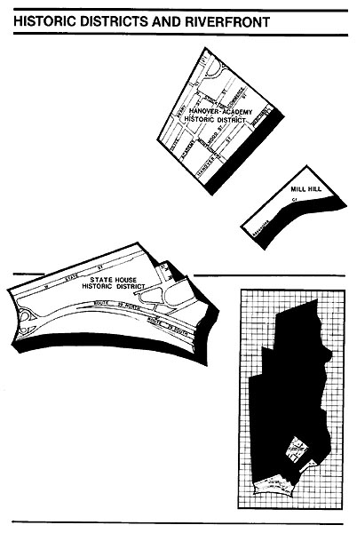
HISTORIC DISTRICTS AND RIVERFRONT
The
existing Academy-Hanover Historic District, and the parts of the State House
and Mill Hill Historic Districts which lie in the North Ward have already
been surveyed and have received only cursory consideration in this survey.
Land along the Delaware River south of the State House Historic District has
been considered independently of any other area.
The Academy-Hanover Historic District consists of one
of Trentons oldest residential neighborhoods. It includes the east-west streets
of East Hanover, laid out about 1735, Academy, laid out about 1774, and Perry,
laid out in 1814. Although development began as early as the mid-eighteenth
century, growth was slow until the opening of Perry Street - which quickly
became more populous than the older streets. Perry Street served as the important
link between Warren Street and the Millham Road
and acquired a partial commercial character. East Hanover Street, adjacent
to the downtown, became popular for professional offices. An industrial zone
developed at the eastern edge of the neighborhood along the canal. For the
most part, however, the area has always been residential. Great growth in
population and housing occurred between 1850 and 1880 when nearly all lots
were developed.
Notable institutions have been founded and have flourished
within the district boundaries. The Trenton Academy preparatory school (1782-1884)
and the Joseph Wood Public School (1857-1932) were two of Trentons premier
educational institutions. They have been replaced by the building of the Trenton
Free Public Library. Trentons earliest church, the Friends Meeting House
on East Hanover Street still stands (1739 with alterations). The First Methodist,
Central Baptist and Trinity Episcopal Churches were at one time located in
the neighborhood.
Mid-nineteenth century Perry Street was a focus of
Trentons small black community. Mount Zion A.M.E. Church, founded in 1816
on the present site, is Trentons oldest black organization. A sizeable Jewish
community was active in the area.
The neighborhood retains its original character with
residential streets lined largely with brick row houses - interrupted by a
few more high-style homes, small office and commercial buildings, and institutional
structures. Few of the buildings are notable solely on their own merits. But
the totality constitutes a representative mixed-class neighborhood of the
nineteenth century. Although in need of revitalization, the Academy-Hanover
Historic District remains one of Trentons oldest and most ethnically and
physically diverse neighborhoods.
The State House Historic District includes structures
on Willow Street and on West State Street, from Willow Street extending a
short distance into the West Ward beyond Calhoun Street. The first ironworks
in New Jersey (established by Benjamin Yard), and the Old Barracks and Old
Masonic Hall were located in the area before the end of the eighteenth century.
The construction of the New Jersey State House on an extension of Second Street
(State) in 1791 ensured further development. South Willow Street acquired
a cluster of institutional buildings, while West State Street developed toward
the west throughout the nineteenth century as Trentons most fashionable residential
street.
Early homes were modest; but this district is a rare
instance of residential redevelopment in Trenton as the original houses were
often replaced by more pretentious structures. In its present manifestation,
West State Street contains worthy buildings representing nearly every significant
nineteenth century architectural style. The more outstanding houses are the
Greek Revival Joseph Wood House, the Italianate Contemporary Club, and the
Romanesque Roebling Row. These are all closely set townhouse-type structures.
(A series of freestanding deeply set back mansions formerly stood on the south
side of the street. These have all been demolished.)
The State House, though repeatedly altered and expanded,
is the countrys second oldest state capital still in use, dominating the
street with its curious nearly freestanding golden dome.
At the corner of West State Street and South Willow
Street is the Kelsey Building, an individualistic Italianate essay originally
designed for the School of Industrial Arts by Cass Gilbert. It features excellent
terra cotta tile and metal work and a tile roof. The monumental Beaux Arts
1929 Masonic Temple and War Memorial Building face South Willow Street in
counterpoint to the eighteenth century Old Barracks and Old Masonic Hall.
Land between the State House Historic District and
the Delaware River lies apart from North Ward neighborhoods and historic districts.
In the eighteenth century, this land was traversed by the stream known as
Petits Run, becoming Trentons first industrial
district with establishments such as Stacy Potts
steelworks. The opening of the Sanhican Creek
water power raceway parallel to the river spawned further industrial growth.
Industry remained in the area well into the twentieth century, as did the
swampy riverfront lowlands which comprised much of the remaining acreage.
In 1911, efforts to develop the area as a riverfront
park began with the construction of a retaining wall and landscaping. The
eventual result was Mahlon Stacy Park. The park,
with its trees, paths, and concert bandshell became
popular with Trentonians as a pleasure ground for
strolling and entertainment. In recent years, the row of mansions which faced
West State Street has been replaced by the New Jersey State Cultural Center.
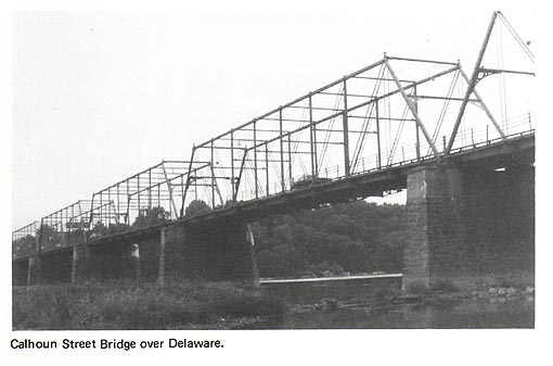
At the very southwestern edge of the North Ward, the
Calhoun Street Bridge crosses the Delaware River. Erected in 1885 by the Trenton
City Bridge Company, the Calhoun Street bridge is a rare surviving example
of a long Pratt truss bridge. It is listed on the National Register of Historic
Places. With the exception of Roeblings Lackawaxen Aqueduct, it is the oldest bridge spanning the
Delaware River.
A small portion of the Mill Hill Historic District
lies in the North Ward, while the remainder is in the South Ward. The area
in question lies just north of the Assunpink Creek between South Broad and
South Stockton Streets. Mahlon Stacys original
mill was in the vicinity, and the Second Battle of Trenton was fought over
the Broad Street bridge over the Assunpink. A narrow seam between the Downtown
and the Mill Hill Mercer-Jackson Streets neighborhood, the area has no particularly
significant community identity of its own.
This small strip along Front Street is now divided
from the Downtown by parking lots and linked to Mill Hill by the park along
the creek. It includes noteworthy structures such as the oft-moved eighteenth
century Douglas House, the former Lutheran Church of Our Saviour,
presently adaptively reused as the Mill Hill Community Playhouse, distinctive
townhouses of a number of eclectic stylistic variations, contemporary housing
for the elderly, and a monumental statue of George Washington.
DOWNTOWN
History &
Development
All
of Trenton was contained in the
downtown area during the eighteenth century. Open land, farms, and woodland
surrounded this compact village. Until the mid-nineteenth century, the history
and development of Downtown was nearly synonymous with the history and development
of Trenton itself.
In
1748, Peter Kalm, a visitor from Sweden, described
the town as follows:
October the 28th. Trenton is a long narrow town
. . . It has small churches. The houses are partly built of stone, though
most of them are made of wood planks, commonly two stories high, together
with a cellar below the building, and a kitchen under ground, close to the
cellar. These houses stand at a moderate distance from one another. They are
commonly built so that the street passes along one side of the houses, while
gardens with different dimensions bound the other side . . . Our landlord
told us that twenty-two years ago, when he settled here, there was hardly
more than one house; but from that time Trenton has increased so much that
there are at present near a hundred houses. 1
As Kalms diary indicates,
houses comprised the largest share of the building stock. A small enclave
of simplified Federal and Italianate row houses along Peace Street and Lafayette
Street (#39, #40) still retains a residential character. In most of the downtown
area, however, houses were gradually replaced or converted to non-residential
uses, especially as the ground floors gave way to storefronts. The Federal
and Italianate structures lining Warren Street between Front and Lafayette
Streets (#52, #54) are perhaps most representative of this phenomenon. A few
blocks north, the imposing Centennial Row (#48) on North Broad Street is a
prominent late nineteenth century example of more elaborate Italianate residences.
2
Change has steadily continued, and downtown is the
only section of Trenton where it is not uncommon for a given parcel of land
to have supported more than one generation of structures. Until the mid-nineteenth
century, the downtown remained a mix of residential, commercial, institutional
and some industrial uses. Trentons buildings have evolved through the years
reflecting the dynamic nature of the downtowns social, institutional and
commercial life.
Transportation
Transportation
was one of the single most powerful factors giving direction to the Citys
growth. In the early eighteenth century, Trenton served as an important transportation
center with stage service between Trenton and Philadelphia; service to New
Brunswick and New York followed shortly thereafter. Initially, the stage route
ran directly through town on Queen Street, which later became known as Greene
Street and finally Broad Street. By the late eighteenth century, however,
the route had been altered; drivers turned west at Second Street (State Street)
and then north on King Street (Warren Street) 3
This new route established a new axis of urban development marked by taverns
and inns, churches, the county courthouse, leading businesses, and the town
street market. 4 However, by the mid-nineteenth
century, Queen Street (Broad Street) had begun to surpass King Street (Warren
Street) in importance, becoming the Citys principal street. At the turn of
the century, State Street became the Citys main business street. As transportation
developed technologically, it had a dramatic influence on the Citys growth.
The development of canals, railroads and street-cars, and the dispersal of
industry and population that resulted, transformed downtown almost entirely
into a commercial and institutional center.
Social Life
Prior
to this more sophisticated, urban life-style, the village was a major crossroads
with many taverns and inns catering to travelers and residents. Village life
revolved around taverns as well as the market place, churches, fraternal organizations,
and theater.
The taverns and inns offered food, drink, and fellowship,
providing ideal meeting places. In 1784, at the French Arms Tavern at King
and Second Streets, Congress met to deliberate naming Trenton the capital
city of the nation. Trenton served only briefly as the presidential and cabinet
seat for John Adams. The French Arms and later the Sign of the Golden Swan
were each, for a time, Trentons most suitable place for large gatherings.
Other popularly frequented institutions included the Rising Sun, the Indian
King, the Phoenix Hotel, and the City Hotel, all on King Street (Warren Street).
Today, the Trenton House (#59), the American Hotel (#60), and the Sign of
the Golden Swan (#55) remain standing. A Federal style building originally
built probably as a residence in 1815 served as the Golden Swan Tavern between
1826 and 1855. It then served as newspaper offices of the True American, predecessor to the Trenton Times, and is presently a custom tailor shop. At the corner
of North Warren and Hanover Streets, the American Hotel, dating from 1847,
has accommodated such luminaries as President James K. Polk and Daniel Webster.
One of the countrys most historic hotels, the Trenton House stands across
the street. The Tremont House (#7), built in 1847 at the corner of East State
and Canal Streets, served travelers on the Camden and Amboy Railroad.
For
Trentonians, day to day activity revolved around
the street market place. Complete with whipping post, stocks and town pump,
it was a favorite place for meeting friends and hearing the latest gossip.
An early nineteenth century observer wrote in the State
Gazette:
A Saturday night in Trenton seems to be particularly appropriate to promenading
. . . seven hundred and fourteen persons passed the corner of Warren and Second
(State) from 8 oclock to 10 last Saturday night. Some with a lady on each
arm; others admirably paired off, and hundreds were promenading single handed
and alone. The industrious mechanic, with his neatly dressed wife - on one
arm, and a capacious market basket on the other - making his purchases . .
. . 5
Besides good conversation and comraderie,
the market stalls offered a wide choice of provisions. Commercial activity
began in shops like that of gunsmith John Fitch,
who later was to launch the first successful steamboat. His shop was located
on King Street (Warren Street), as was the general provisions store of the
leading merchant, Abraham Hunt. 6
The churches, likewise, provided fellowship and served
as meeting places. Prominent churches included St. Michaels Episcopal (#65)
The English Church 1784, the First Presbyterian Church (#23) 1728, the First
Methodist (#41), St. Marys Cathedral (#69), and St. Francis Roman Catholic
Church (#36). While these congregations still have prominent buildings in
the downtown, only St. Michaels remains in its original building, although
in a much altered form. St. Michaels Church on North Warren Street was originally
constructed in 1748, and subsequently rebuilt a number of times. 7
The present facade, dating from 1851, is a fine and rare example of a castellated Gothic Revival design. The Classical Revival First
Presbyterian Church on East State Street (#23) dates from 1841. Both churches
have flanking churchyards with gravestones dating from the eighteenth century.
The daughter of Joseph Bonaparte is buried at St.
Michaels; Colonel Rall and a handful of Hessians, and the first three mayors of Trenton are buried
at the First Presbyterian. The brownstone former Third Presbyterian Church
on North Warren Street was built in 1850 (#67); the St. Francis Roman Catholic
Church building now sheathed with permastone, dates
from 1841 (#30); the Romanesque First Methodist Church, a tall tile-faced
building with Gothic detailing, dates from 1894 (#41).
Fraternal organizations also built prominent structures and contributed much to community life. The Masons, in particular, played a distinguished role in Trenton social and political life. Organizations such as the Elks (#62) and the Eagles (#65) established downtown lodges. The Elks Lodge is a romantic extravaganza of brick and stone with geometric tile inlays.
Theaters also emerged as a new focus of social life
and entertainment during this period. The first large theatrical hall, the
Taylor Opera House, opened in 1867; it became known for its vaudeville performances.
Other halls followed, leading to extravagant movie palaces such as The
Trent and The Lincoln.
Along
with social activities, a number of both private and public institutions emerged
as an integral part of downtown Trenton.
In 1719, Trenton became the county seat of Hunterdon County. Mercer County was created out of Hunterdon and a portion of Burlington Counties. The towns
primary institutional building was the Hunterdon
County Courthouse and Jail on King Street (Warren Street), built in 1730 (#56).
In 1753 the townspeople saw construction completed on the first post office,
also on King Street (Warren Street), and a school on Second Street (State
Street).
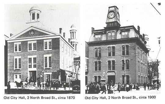
Trentons first City Hall (#42) built in 1836, holds
a particular interest because of its metamorphosis. 8
Originally designed in the Federal Style, a French Second Empire mansard
roof and clock tower as well as new fenestration and brick cladding were the
results of a late nineteenth century remodeling. In its present form, the
building stands without its tower while the upper floors fenestration has
given way to tall glass block panels. The first floor has been totally rebuilt.
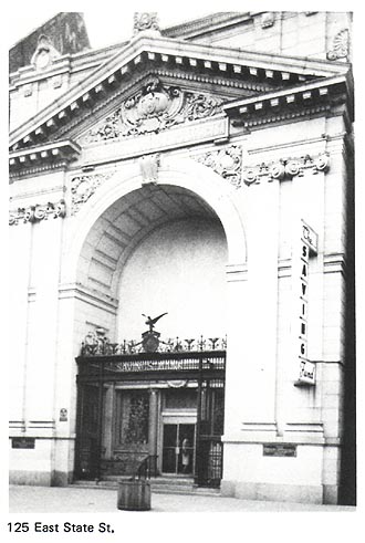
During the late nineteenth century downtown Trenton also became a banking center. In fact, banks now assert the most commanding physical presence in the area, characterized by the dignified, stolid presence of a series of Classical/Beaux Arts structures. This academic style provided an appropriate iconography for banks, the financial pillars of the community. The greatest flourish of this style appears in the Trenton Savings Fund Society (#19) at 123 East State Street.
The monumental New Jersey National Bank building (#30),
originally the First Mechanics National Bank, is located at the corner of
West State and South Warren Streets. A prime example of downtowns continuous
evolution, this structure is on the site of three generations of bank buildings.
9 Originally this corner was the site of
the French Arms Tavern.
Neo-Classically detailed office towers above the
main banking halls represent another type of bank structure. These office
towers, downtowns tallest and most ambitious buildings, are often topped
by massive advertising signs (#15, #35).
Downtown Today
Today,
the physical character of eighteenth and nineteenth century downtown is most
evident and best preserved on Warren Street. South Warren Street (#30, #52,
#54, #55, #56) and North Warren Street between State and Bank-Perry Streets
(#29, #57 through #69) boast architecturally varied streetscapes including
churches (#65, #67, #69), former inns and hotels (#55, #59, #60), noteworthy
Italianate commercial buildings (#30, #52, #54, #57, #63,
#64, #66) and Trentons most significant pressed metal facade at the True
American Building (#58).
The mid-nineteenth century shift of preeminence from
Warren Street to Broad Street is marked by buildings such as the large four
story Italianate commercial structure bearing an
1856 datestone (#43).
Today, downtown commercial activity focuses around
a two block pedestrian mall located on East State Street flanking Broad Street.
The Commons contains a number of notable architectural compositions. At 9
East State Street (#25) a Victorian pressed metal ornamental facade dated
1896 is dominated by a more recent, yet significant porcelain enamel and neon
Flagg Brothers Sign.
Across
the street the McDonalds facade at 12-14 (#28), combines Art Deco and Classical
motifs forming a uniquely modern composition. Once a Horn and Hardart this building has housed two generations of fast food
establishments. The Commons also includes a simple Art Deco Woolworths (#20)
as well as the quietly modernistic Kresge Store
(#21).
Although the street markets, the town pump, and the
whipping posts have disappeared, the Commons possesses a special character
all its own and provides the public with numerous shops.
1 Turk, Trenton, New Jersey in the Nineteenth Century;
p. 60.
2 Centennial Row was erected by the Rev. Anthony Smith,
a priest at St. Marys Cathedral. See Walker, et. al., A History
of Trenton, pp. 324-325.
3 Turk, Trenton, New Jersey in the Nineteenth Century;
p. 44.
4 Harry J. Podmore The Historic
Five Points in Trenton; The Silent
Worker, Vol. 33, no. 2, November, 1924, p. 55.
5 Harry J. Podmore, Trenton Old and New (Trenton: Trenton Tercentenary
Commission, 1964), p. 84.
6 Walker, et. al., A History of Trenton, pp. 107-108.
7 Hamilton A. Schuyler, A History of St. Michaels Church, (Princeton:
Princeton University Press, 1926).
8 Podmore, Trenton Old and New, pp. 94-101.
9 Podmore, Trenton Old and New, pp. 59-64.
FIVE POINTS
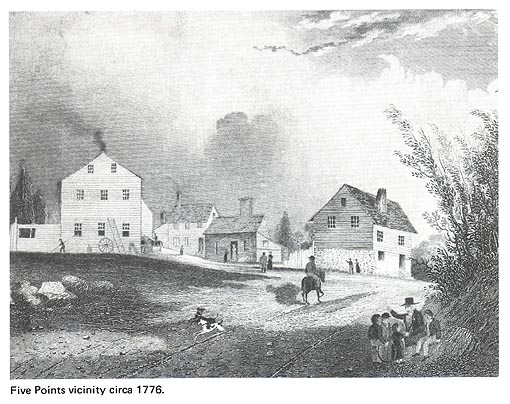
The
Five Points area focuses on the star-shaped configuration created by the convergence
of five streets: Princeton, Pennington, and Brunswick
Avenues and North Warren and North Broad Streets.
An
entrance point to the City for most of Trentons early history, it functioned
as both gateway and community, dating back to the eighteenth century when
King (North Warren) and Queen (North Broad) Streets were first laid out to
converge north of the town leading to New Brunswick, Pennington,
and Princeton. Historian Harry J. Podmore relates
that, Under the influence of traffic there came into existence at this gateway
a little community with its quaint dwellings, taverns and shops. It became
a little mart in itself: 1 Furthermore:
Through these highways came the early Dutch trader with his heavy pack,
the stagecoach and lumbering freight wagon, the travelling showman and magician,
the road circus and the postrider with the momentus news that patriot blood had been shed on the village
green at Lexington and that Cornwallis had surrendered
of Yorktown. 2
The American Revolution
Five
Points saw more of the Revolution than just a postrider
proclaiming news of the most recent battle. When the Continental forces made
their surprise river crossing and early morning attack on the complacent Hessions at Trenton, General Washington and Major General
Greene and his troops marched down Pennington Road
and hurriedly set up six cannons at Five Points. From this vantage point,
artillerymen directed fire down both King and Queen Streets
toward the Hessians stationed in the center of town.
Meanwhile, General Washington surveyed the scene from an elevated field beside
Beakes Lane (Princeton Avenue at Fountain Avenue). The Hessians, unable to offer much organized resistance, withdrew
to The Swamp; an area east of Montgomery Street; here they surrendered.
3 To commemorate the First Battle of Trenton
on the strategic site where Continental cannons were stationed, a monument
was constructed and dedicated with much fanfare in 1893. The Battle Monument,
(#108) designed by John H. Duncan, F.A.I.A., the architect of Grants Tomb,
is a one hundred fifty foot high Roman Doric column set on a large pedestal
with bronze reliefs surmounted by an observation
platform capped by a statue of Washington. The Battle Monument remains one
of the Citys most imposing landmarks, anchoring the Five Points intersection
and providing a focus for the North 25 Park.
At the same time of the Revolution, Five Points was
already considered a small community. The house of Continental soldier Thomas
Case, the Lamb Tavern, and the Sign of the Fox tavern, as well as other structures
were located in the immediate vicinity. 4
Other shops and dwellings quickly appeared, erected on North Warren and North
Broad Streets above Perry Street, connecting central Trenton with the Five
Points community.
Manufacturing: Artisans to
Industry
In
the nineteenth century, the immediate Five Points vicinity evolved as a center
for artisans. The Thomas Case house, at the fork of North Warren and North
Broad Streets, became a blacksmith shop, and was later replaced by the Valentine
Carriage and Wagon Works. A coffin maker and tin shop were located on North
Warren Street and a wheelwright and blacksmith shop on Pennington Avenue specialized in wagon bodies for nearby brickyards.
5
Early small scale industries concentrated south of
Five Points including a pottery to the rear of Lambs Tavern, a tannery above
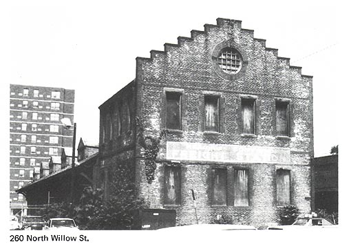
Bank Street and a stone mill in Honey Hollow (east of North Willow Street
by the Belvidere Division railroad). This mill was
known as the Coffee House and was utilized for grinding spice and roasting
coffee. A millpond on Petits Run supplied a conduit
which turned a paddle wheel which, in turn, powered the mill. Later, however,
horse power was utilized with a sweep, which proved an irresistible temptation
to neighborhood boys for taking a ride. 6
However, as late as 1850, the Five Points area was surrounded to the north
and to the west by open farm country and meandering livestock.
Among the later industries was The Fitzgibbons and Crisp Union Carriage Works (#77) established
on Bank Street in 1868. The firm, housed in three and four story brick structures,
was for many years a large producer of carriages, horse drawn trolley cars,
and finally truck and automobiles bodies. The company, which exhibited at
the Centennial Exhibition, was described as one of the most complete manufacturers
of its kind in the country, ranking with the great wagon manufacturers of
the Northwest. 7
Because Five Points functioned as a commercial and
popular gateway to Trenton from the start, it was only natural that construction
of railroads with their freight and passenger depots near North Warren Street
ensued. The Belvidere-Del aware Railroad (later
the Pennsylvania Railroad line) was constructed in 1852; the Delaware and
Bound Brook Railroad branch (later a Reading Company line) followed in 1876.
Twelve years later the Philadelphia and Reading Freight Terminal (#143) was
constructed serving the industry established in this area. The Terminal, a
long elegant brick structure with a distinctive two story gable and office
wing is the sole surviving nineteenth century railroad terminal in Trenton.
As part of the North 25 Redevelopment area, it is being adaptively reused
as a senior citizen center.
Residential Development
Land
association and private developers subdivided land in the area in the second
half of the nineteenth century. Harriet Wilkinson, for instance, whose son
Ogden later became active in real estate development throughout Trenton, subdivided
land along Rose Street and Fountain Avenue. Actual development usually involved
individual lots and small tracts.
Generally, side streets feature densely-sited small,
attached vernacular houses, while main streets such as North Warren Street,
and Brunswick, Princeton and Pennington Avenues
contain clusters of more sophisticated freestanding twin and row houses.
The most notable house on Princeton Avenue is the Fell
homestead (#136) a showcase of brickwork created for Trentons leading brickmaking family. Both the Queen Anne main house with its
cross gables and two-tier corner porch, and the extraordinary outbuilding
behind (#137), display elaborate brick and terra cotta ornamentation. The
Fells built the sprawling Queen Anne twins at 144-154 Pennington
Avenue (#152, #154, #155) in a variation of the style of their own home. 8
The richest collection of residential structures in
the Five Points area is on North Warren Street above Perry Street (#81‑#90).
These homes lined the important approach from Five Points along Warren Street
into the downtown. Greek Revival, Italianate, Queen
Anne, Neo-Renaissance, and other vernacular variations are represented. The
large freestanding house at 221 North Warren Street (#80) was built in 1813
by Robert McNeely, mayor of Trenton from 1814 to
1832. A quite substantial house for the period, its simple Federal lines were
embellished with Colonial Revival and Italianate
details when remodeled in 1915. 9 The east-west connecting streets
between Calhoun Street and Princeton Avenue, including
Fountain (#170-#171) and Sweets Avenues (#166-#169) feature randomly intermixed,
simple vernacular Greek Revival/Italianate, and
Italianate/Gothic houses. These streets are so long
and narrow that even the small two and three story houses create a modest
canyon effect.
The foremost rowhouse groups
are 612-626 (#141) Princeton Avenue, with dormers and unusual cutout detailing
and a quite different group at 116-124 Brunswick Avenue (#110) with orange
brickwork and contrasting brownstone trim.
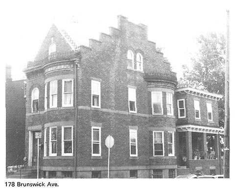
On Brunswick Avenue opposite Cavell
Street a residential cluster of more high style character and variety includes
a freestanding Second Empire structure at 194, (#120) a pre-1850 Greek Revival
twin at 184-186 (#117) (an Italianate third floor
has been added at 186), an Italianate townhouse
at 182, (#117) and a large eclectic rusticated-brick house at 178 (#118) featuring
stepped gables and rounded bays, and brownstone, pressed metal, wood and wrought
iron detailing.
Community Institutions
During
its history, many different ethnic groups have inhabited the Five Points area
and maintained community institutions. During the eighteenth century the English
settled the area. As the area developed, Five Points was settled by Blacks
in the area east of Montgomery Street, (known as the Swamp) and by Irish
in the vicinity of Bond Street.
The communities maintained a vital volunteer fire department,
the Harmony Volunteer Fire Department Company located on Tucker Street. Five
Points also supported an Orthopaedic Hospital housed
in several locations before construction of a building on Brunswick Avenue
in the early twentieth century. This simple yet formal Art Deco building on
Brunswick Avenue (#121) was erected on the site of the Charles May Mansion
which had been adapted to serve as a hospital.
The
Orthopaedic Hospitals services were later merged
with Mercer Hospital. The Lincoln Public School (#107), a handsome Mediterranean
adaptation of the Romanesque style was built expressly for black children
in 1924.
The community also built several churches. The Fifth
Presbyterian Church (#131) on Princeton Avenue, a picturesque Victorian Gothic
complex, has become the Galilee Baptist Church. Our Lady of Divine Shepherd
(#149), a granite Neo-Classical structure on Pennington
Avenue, was originally constructed as a lodge.
Notes
1 Podmore,
The Historic Five Points in Trenton.
2 Podmore,
Trenton Old and New, p. 11.
3 Walker, et. al., A History of Trenton, pp. 149-166.
4 Podmore,
Trenton Old and New, pp. 9-15.
5 Harry
J. Podmore, Head of Town, State Gazette, January 26, 1910.
6 Harry
J. Podmore, Head of Town, State Gazette, March 29, 1920.
7 Department
of Planning and Development, City of Trenton, An
Inventory of Historic
8 Land
Development Map; Trenton in Bygone Days; Trenton
Sunday Times-Advertiser,
9 Vertical
File: Fraternal Organizations - Knights of Columbus, (Trentoniana
Collection,
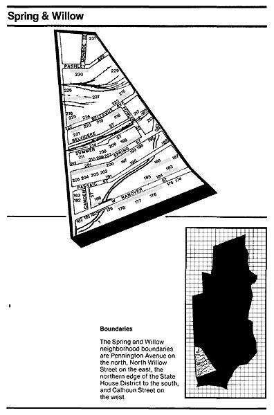
SPRING AND WILLOW
The
Spring-Willow Street area was quite rural during the Revolutionary War period.
Its leading street, River Road, now supplanted by Hanover Street, was a mere
country lane through the woods. However, the area did play an important role
in the Battle of Trenton when General Sullivan of the Continental Army marched
through it on Pennington Road and Willow Street,
forcing the Hessians into crossfire from the Continental
Armys positions in the adjacent Five Points area. 1
After the Revolution, in 1790, Trenton was named the
state capital, and during this period, several streets, including West State
Street, were laid out. Calhoun Lane was also created
on a north-south line from Pennington Road to Beattys Ferry on the Delaware River, providing a link to
Pennsylvania.
With
the establishment of State Street, River Road became a primary route for the
local construction industry which transported the stone quarried amid farms
and open land west of Willow Street. Because of its direct route and proximity
to the quarries, by the mid nineteenth century, River Road became known as
Quarry Street (later West Hanover). The flinty grey
stone quarried was used originally for such structures as the Old Barracks
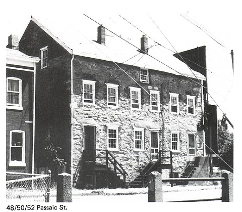
and the building at 48-50 Passaic Street (#191), the oldest building in the
Spring-Willow area. 2 Now divided as three
dwelling units, it was originally a barn, and probably dates from the days
of land ownership of the Higbee family. Built of stone, and sited on a hillside, the
structure had a stable entrance on the downhill side, as well as a carriage
entrance at the second floor. Defined by Calhoun
and North Willow Streets, the open fields in which the barn stood were divided
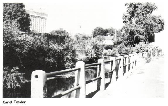
from east to west by the canal feeders, railroads and streets.
During the early nineteenth century, commercial activity
shifted from actual quarrying to stone cutting and dressing. By 1834, construction
of the navigable Delaware and Raritan Canal Feeder
facilitated shipments from the outlying quarries to the Quarry Street stone
yards. John Grant operated the foremost yard on a large tract north of Quarry
Street (West Hanover), adjacent to the canal feeder. Brownstone was quarried
near Wilburtha and transported by canal to the Grant
stone yard, where it was cut, dressed and sold for construction throughout
Trenton and elsewhere. At the peak of operations, the Grant yard handled.
thousands of tons of stone at a time, utilizing its own fleet of canal and
river barges. 3 The feeder also served as
a location for other industries including the Star Chain Works and the Blackfan
and Wilkinson coal and lumber yards.
The advent of the railroads in 1852 and 1876 resulted
in two east-west right-of-ways and additional industrial development north
of Quarry Street. Both railroads have been largely removed leaving a narrow
grassy depression between Belvidere and Summer Streets
and open land which has been redeveloped as the North 25 housing project (#227).
A remnant of the days of railroad and industry is the former Wilson &
Co. meat distribution building at 283 North Willow Street (#229), which sports
a carved bulls head projecting from the facade.
Residential Development
In
the middle and late nineteenth century, residential development occurred in
the area. Prior to such development, many canal boats wintered in the basin
at the Blackfan and Wilkinson yard, and the captains and their families
often lived aboard the ships through the winter. By the mid 1800s, east-west
residential streets were created. Many land subdivisions also were registered
in the 1850s by S.M. and Charles Higbee. The street
which bore the name of these developers was later changed to Bellevue Avenue.
The Wilkinson family also made reinvestments in the
areas residential development. They developed part of the modest eastern
end of Spring Street in the 1860s, while the western end experienced more
high style development. John Clearys essay Trenton
Caught Building Lot Fever in Early 70s . . . quotes from an 1871 State
Gazette: Although the growth of the
city appears to be eastward and
southeast, yet there are few handsomer
locations than are to be found in
all this section (Spring Street) of the city. 4
Many houses were reported going up on Spring Street, and the presence of
a sidewalk on the northern side between Fowler and Calhoun
Streets received special comment. Fundamentally simple buildings given a unique
elegance by their groupings and fine detailing lined this areas streets,
with more extravagant homes an exception.
Residential development was further stimulated by the
appearance of trolley lines on West Hanover and North Willow Streets, and
finally on Spring Street in 1885.
Spring and West Hanover Streets are still among two
of the most distinctive residential streets in the North Ward. The eastern
end of Spring Street is lined with simple vernacular, freestanding and attached
frame houses (#195-#199). A slight cant in the street marks a change in character
as large Second Empire and Neo‑Renaissance structures face each other
(#200-#210). Further west, a collection of nine elegant Second Empire twins
represents variations on a theme (#211); their bracketed entry ways topped
by gracefully curving, projecting roofs, and the corresponding mansard roofs
supported by paired brackets unify the composition. The usually simple Trenton
Italianate/Gothic twins at 96-98 (#207) share a
similar quality of the more elaborate Second Empire Twins by having wood ornamentation
in the form of pedimented window and doorway hoods,
an entryway with doubly recessed reveals and vine-like bargeboards. An imposing Queen Anne structure with a projecting
turret elegantly punctuates the corner of Spring and Calhoun Streets (#212).
West Hanover Street features handsome but very plain
Italianate/Gothic twins and has numerous clusters
of rowhouses. Adjacent to the former site of the Grant stone
yard, houses at 193-211, 204-208 (#177) and 304-316 (#186) appropriately feature
a generous amount of brownstone which lends an air of solidity and permanence.
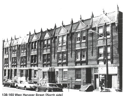
The picturesque rowhouses built by Ogden Wilkinson
on the north side at 138-160 West Hanover Street (#183) have been described
as patterned after Elizabethan townhouses of the nineteenth century; 5
the Germanic influence in the roof ornament also reflects the early twentieth
century trend of European styles popularization in the United States by returning
American tourists. Whatever their precise stylistic origin, the composition,
characterized by multi-colored patterned brick and flamboyant pressed-metal
cornices makes for a unique grouping.
In contrast to the relative high style of Spring Street
and the solidity and flamboyance of West Hanover Street, a few frame cottages
exhibit simpler techniques. The structure at 82-84 Bellevue Avenue (#224),
originally built as an ice skating clubhouse, 6
is a variation on the Victorian Cottage theme and is likely to have been pattern-book
derived. Its gently gabled roofline features gracefully curvelinear trim. The otherwise austere building is enlivened
by a wrap-around porch defined by unique three-stage square wooden posts.
Jigsawn vine-like bargeboards
edge the widely overhanging eaves on four sides. This is the oldest of four
structures in the immediate vicinity bearing this vine-like detailing, found
nowhere else in the North Ward. A workers cottage at 120 Calhoun
Street (#192) is representative of its type with jigsawn
balustrade and bargeboards.
By the turn of the twentieth century, business had
relocated and West Hanover Street reemerged as a residential street. Around
the corner at the site of the former Blackfin and
Wilkinson coal and lumber yard, Wilkinson later laid out Wilkinson Place (#188),
constructing forty-one row houses with apartment buildings (#187) flanking
the North Willow Street entrance. 7 Wilkinson
retained total control of the enclave. Instead of selling the houses, he rented
them; instead of dedicating the new street to the city, he maintained it as
a private court. A city ordinance providing that any private street open to
the public for twenty years become public property prompted Wilkinson to periodically
close the street. Eventually, problems with municipal services dictated his
deeding the street to the city.
Community Institutions
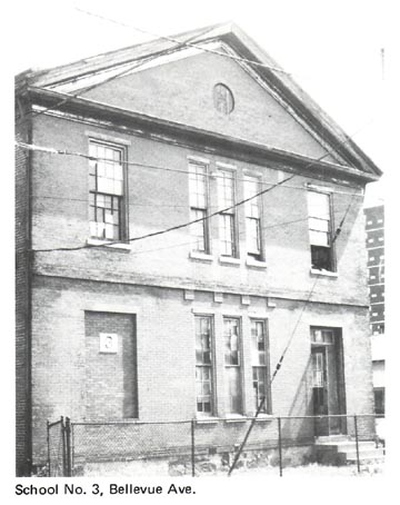
Although the Spring-Willow area was predominantly a white working class neighborhood until the twentieth century, the areas significance to Trenton Blacks dates back to a much earlier period. In 1857, the Higbee Street (Bellevue Avenue) school (later known as the Nixon School) was constructed; it served as Trentons first school specifically intended for black children. This school building at 20 Bellevue Avenue (#223) is the North Wards finest example of a simple Greek Revival temple form structure. In addition, Shiloh Baptist Church, presently in a contemporary building on Calhoun Street (#216), organized prior to 1888, was housed in a building on Belvidere Street as early as 1897.
During the early twentieth century Black immigrants
began to settle in Trenton, and Black professionals located homes and doctor
offices on the western end of Spring Street. A 1929 article in the Sunday Times Advertiser noted that the
area was inhabited by Trentons middle and upper class Blacks. 8
During this period Blacks organized several additional
institutions to serve their newly increased community. St. Monicas Mission for Colored People (Episcopal) was founded
in 1919 and subsequently established on Spring Street. The congregation later
merged with St. Michaels.
In 1927 the Sunlight Elks Lodge I.B.P.O.E. erected
a large meeting hall at 40 Fowler Street (#217). Hosting such performers as
Cabs Calloway and Fats Waller, it doubled
as an entertainment center. A YMCA for Black youths was organized in 1927
and operated in various neighborhood buildings until it moved in 1944 into
the former Elks Lodge, rechristening it the Carver
Center. 9 The Center is presently operated
by the New Jersey State Federation of Colored Womens Clubs.
1 John J. Cleary,
Trenton in Bygone Days: West Hanover Street Has Seen Many Changes. . . ,
Trenton Sunday Times-Advertiser, July 17, 1960, (Trenton in Bygone Days, vol.
12, p. 122).
2 John J. Cleary,
Passaic Streets Revolutionary Landmark . . . ; Trenton Sunday Times-Advertiser, March 30, 1924, (Scrapbook of Trenton History, vol. 1, p. 47).
3 Cleary,
Trenton in Bygone Days: West Hanover Street . . . .
4 John J. Cleary,
Trenton Caught Building Lot Fever in Early 70s; Buyers Rallied for $4,000
Prize; Trenton Sunday Times-Advertiser,
April 10, 1921, (Memorable Yesteryears
for Trenton, vol. 2, p. 88).
5 Unusual Buildings Mirror
Citys Past; Trenton Sunday Times-Advertiser,
November 8, 1964.
6 Harry J. Podmore, Trenton in Bygone Days: Ice Skating Was Popular
Winter Sport Here At Close of Civil War. . . ; Trenton Sunday Times-Advertiser, January 2, 1955, (Trenton in Bygone Days, vol. 10, p. 95).
7 Wilkinson Place Has Unique
Distinction - Its the Only Private Street in City of Trenton; Trenton Times, July 7, 1952.
8 John J. Cleary,
Trenton in Bygone Days; Trenton Sunday
Times-Advertiser, May 12, 1929, (Scrapbook
of Trenton History, vol. 3, p. 109).
9 Vertical File: YMCA-Carver
Branch, (Trentoniana Collection, Trenton Free Public
Library, Trenton, New Jersey).
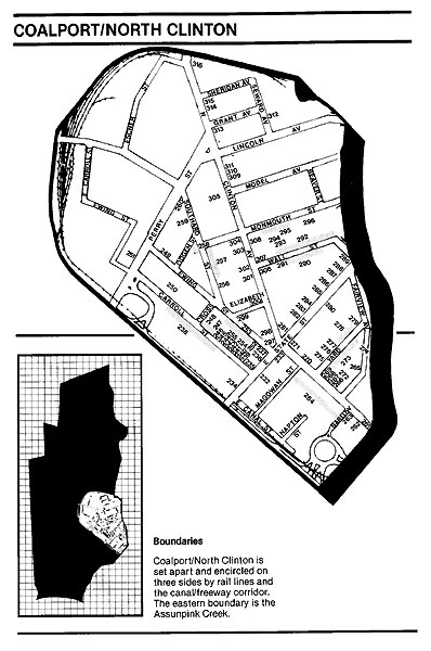
COALPORT/NORTH CLINTON
The
Coalport/North Clinton Avenue neighborhood has been
an area of contrast throughout its history. Industry grew amidst verdant farmland,
while imposing mansions stood blocks away from brick rowhouses. The earliest eighteenth century development in
the open lands to the northeast of Trenton was an iron works established by
Samuel Henry along the Assunpink Creek near East
State Street. The area developed further when Charles Higbee
constructed a mansion surrounded by pastorale countryside,
shortly after the Revolution.
Throughout the nineteenth century, land subdivisions
were registered by land associations, such as the East Trenton Land Associations,
and by private individuals including Ion Perdicaris.
However, the canal and the railroads, rather than one person or group, helped
most to stimulate development. During the early 1830s, the Delaware and Raritan Canal was constructed, separating this area of town
from downtown Trenton. In 1839, the Camden and Amboy
Railroad and Transportation Company laid tracks that followed the canal along
the east side tow path with a station at the crossing of East State Street
and the canal. 1 The railroad offered the
first through rail service linking Trenton with New York and Philadelphia.
Across from the Camden and Amboy
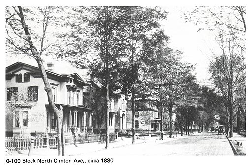
rail station on the south side of East State Street, on the site opposite
the present Federal Building (#234), many impressive homes, referred to as
Cottages; were built during the 1840s for Trentons prominent families.
These similar but distinctive squarish homes with
Greek Revival detailing featured spacious lawns. Much later, in the early
years of this century, the homes were celebrated as once Trentons swellest little colony of houses 2
These buildings are no longer extant.
In 1849, land north of East State Street was subdivided
by J.M. Raymond, W.P Sherman and Thomas Cadwalder.
What could be Trentons first sale of building lots soon followed. Lots were
advertised as Near the Canal and Railroad Depots. The neighborhood which
took shape included Carroll, Ewing and Southard
Streets, south of Perry Street.
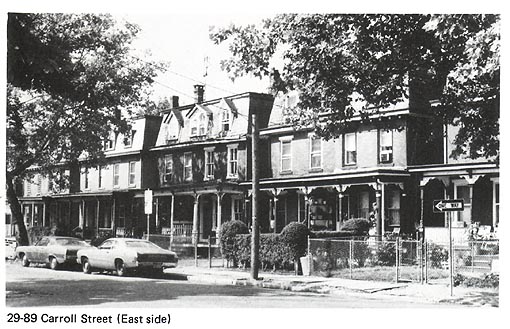
Carroll Street is lined with fifteen vernacular Second
Empire twins and structures of diverse Victorian derivation (#238-248). Six
irregular row houses at 20-30 Carroll Street (#242, #243, #244) are articulated
as twins, each twin featuring different window, porch and roof treatments.
Large inset marble blocks unite the composition. In the same vicinity, Southard
Street has Italianate twins (#257), an apartment
building with Romanesque arches (#256), and a small Greek Revival cottage
(#259).
In the 1850s, residential development grew into the
farm lands of Millham when the Pennsylvania Railroad
built a second depot near the Assunpink Creek
at South Clinton Avenue (#265). Notable portions of the station, which was
rebuilt numerous times, include the cast iron columns and latticework hoods
of the train platforms, and the simple glazed white brick Art Deco towers.
3
The presence of the railroad station at the crossing
of South Clinton Avenue and the Assunpink Creek
also resulted in an area of specialized land use with a number of hotels in
the immediate vicinity. Hotel Penn (#263), the largest remaining is dominated
by an ornate broken pediment.
The dramatic role these railroad depots played in residential
development cannot be overstated. The growing cluster of neighborhoods including
properties on Carroll and Southard Streets in addition
to the more recently developed Yard Avenue, South Clinton Avenue, and East
State Street came to be referred to as the Railroad Age community. Houses
in this elite area were developed in groups so they possess similar architectural
qualities.
Yard Avenue has a split character with large Second
Empire twins on the north side (#272, #275, #277, #278), and three-story townhouses
on the south side (#272, #274). A number of individualistic dark stone and
brick Queen Anne and Romanesque inspired dwellings line South Clinton Avenue
(#266, #270). Stone of various hues and textures comprises the facade triptych
at 42-46 (#268). This stonework is a counterpoint to Trentons more typical
virtuoso brickwork. These homes, as well as the stone structures at 48-52
(#266, #267) were erected by Thomas H. Prior, a stone contractor. Remaining
residential structures on East State Street include massive Second Empire
(#281, #282, #284, #286), Colonial Revival (#285, #287), and Romanesque (#288)
derived houses. Comparison of Second Empire houses in the area such as 29-91
Carroll Streets (#238), 47-61 Southard Street (#258),
17-17 (#272), 18-29 (#275), 28-54 (#277-278) Yard Avenue, 55 North Clinton
Avenue (#301), and 506-508 and 528 East State Street (#281, #282), reveals
the flexibility of this stylistic theme, utilized extensively in this generally
elite Railroad Age neighborhood.
Another first class residential district developed
along East State Street and North Clinton Avenue. 4
North Clinton Avenue boasted many mansions, including those of diplomat-entrepreneur
Gregory Perdicaris, pottery executives James Moses, (#302) and Charles
Breadley (#303), businessmen D.P Forst and Samuel B. Packer (#304), and Mayor Welling G. Sickle.
Two-time Mayor and rubber baron
Frank Magowan built Magowans
Folly (#308), an extraordinary mansion on North Clinton Avenue, but years
later, in financial ruin, he was forced to sell all of his properties and
watch his mansion dismembered.
Charles Chauncey Haven, a
visitor to Trenton in 1866, enthusiastically described the North Clinton Avenue/East
State Street vicinity in a booklet entitled Annals of the City of Trenton
with Random Remarks and Historic Reminiscences:
East State Street, as it is now, extended into the country, in the vicinity
of the new depot, with the horse rail cars passing through it to the hotels
and the Delaware, running by the Cottages and the venerable row of trees planted
early in the century by Charles Higbee, Esq., and
the Fourth Presbyterian Church, a structure unsurpassed in this state as a
model of architectural beauty, present(s) a combination of advantages which
insure advanced improvements in that quart of the city. Travelers entering town often stop at the corner
of State and Clinton Streets, and are struck with admiration, bordering on
surprise, to see such charming residences and picturesque scenery in Trenton;
and if they extend their walk up Clinton Street and the elegant private mansions
and shady walks . . . their astonishment is unbounded. They go away charmed
with Trenton. 5
At this time a passerby might have caught a croquet tournament in progress on the grounds of the Parker House or visited the favorite spot for winter sleighing on North Clinton Avenue.
Although virtually all surviving mansions serve institutional
purposes, North Clinton Avenue has retained much of its dignity. Architecturally,
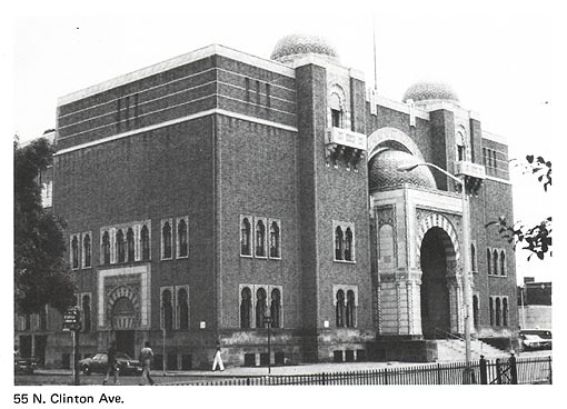
it remains the areas premier address. The former home of James Moses, now
the Scottish Rite Temple, stands at 65 North Clinton Avenue (#302). The building
is a fantasy of stone and slate with highly picturesque roofline. The home
at 73 North Clinton Avenue, now housing the Mount Carmel Guild, is one of
the citys finest Italianate Villas (#303). To the
north, 79 (#304) is an earlier Italianate house
with squarish massing, knee windows, and a highly
detailed brownstone and iron fence. The primary nineteenth century owner was
Samuel B. Packer, a stone and slate dealer, who left his name neatly carved
on a large stone block, just inside the front gate. He developed Packer Row
in North Trenton. Across the street is a deeply set back seven unit row. The
central unit, with rounded front porch, is all that remains of Magowans Folly. With some imagination, one can picture the
mansion as it was with winding stair, gold paneled ceilings, silk wall coverings,
bronze chandeliers, a music room, library, and ballroom, lengthy verandas,
gardens and orchards . . . , 6 before the
financial and political ruin of its flamboyant occupant. Not far from the
social and architectural grandeur of this area stood Coalport,
a working class neighborhood north of Perry Street. For many years the Swamp
Angel sat on a pedestal at the intersection of Perry Street and North Clinton
Avenue dividing the two separate neighborhoods. This Civil War cannon, fired
from the marsh battery at the City of Charleston during the Battle of Fort
Sumter, marked the transition between Coalport
and the more prosperous part of the neighborhood. 7
In 1961, the relic was moved to Cadwalader Park.
The Washington Building Association had subdivided
Coalport into about 300 lots for residential development in
1851. 8 At the same time industry and coal
yards marked the western portion of the Coalport
area at the juncture of the main canal and the feeder. There were canal facilities,
a railroad roundhouse, and a few potteries. The
Thomas Maddock & Sons Pottery (#249, #250),
the first major manufacturer of sanitary porcelain in the United States, stood
at the fringe of Coalport and was the most important
local industry. 9
The circa 1885 buildings are rhythmically articulated
by windows with white Italianate window hoods; the
Ewing Street building features large segmented pediments
as parapets. This industrial complex represents one of a number of complexes
altering the areas residential fabric. Some are well-designed assets, while
others are nondescript intrusions.
Once narrow streets and dense residential development
characterized most of the Coalport neighborhood
populated largely by Irish. The residents fondly gave Coalport another name, Goosetown,
because of the numerous geese inhabiting the marshes. Among organized community
activities was the Thomas D. Burns Fife and Drum Corps which practiced in
front of the Burns Grocery. Residents also visited a makeshift circus ground
in the Yard Avenue vicinity where both Dan Rices and Barnums
circuses played. 10 The two classes met in
rather bizarre fashion when Old World Color would assail Goosetown
on an occasional Sunday in the warm Spring or Summer, when Mayor Welling G.
Sickle in grey top hat and appropriate suit would
drive his six horse tally-ho through Southard Street
and up over the bridge on his way to Lawrenceville
or Princeton. With a large party of friends aboard and two liveried buglers
atop the rear to herald the tally-hos approach,
it was always something of an event. 11
Coalport, a solid community for some
time, was, however, by the mid-twentieth century slated for urban renewal
and industrial redevelopment. The execution of this plan by the Coalport
Redevelopment Authority resulted in a radical change in the areas character.
12
With the demise of residential Coalport,
working class housing is restricted to a small quadrant to the northeast,
and Wall Street. Lined with brick attached houses on the north side, and twin
detached frame houses on the south side, including two Workers Cottages with
setbacks, Wall Street is a particularly good collection of typical Trenton
housing types (#290-#293).
The North Clinton/Coalport
area also had several institutions which deserve mention. Organizations such
as the Crescent (#306) and Scottish Rite (#302) Temples, The Knights of Columbus
and the YMCA (#271) located in the area. The Mercer Cemetery (#264) was established
in the mid-nineteenth century at Trentons first non-sectarian graveyard.
Three Gothic brownstone churches punctuate North Clinton
Avenue. Reflecting the social character of their immediate neighborhoods,
the churches increase in size, complexity, and stylistic purity, from north
to south between Sheridan Avenue and East State Street. Unfortunately both
of the more prominent structures, the former Fourth Presbyterian and Jerusalem
Baptist, have lost their lofty spires.
The Normal School, the forerunner of Trenton State
College, and the Middle School, both teacher training schools, were built
in the neighborhood as well.
The Grant School (#305), constructed in 1938 on the
site of the state schools, is an extremely fine example of Art Moderne design. Curvilinear surfaces and metal detailing articulate
orange brick facades.
Notes
1 Walker et. al., A History of Trenton, pp. 282-283,
287-288.
2 The Cottages Which Were Once
Trentons Swellest Little Colony of Houses, Trenton
Free Public Library, Trentoniana Collection, Vertical
File: Streets.
3 The platform and elevator
towers are actually in the East Ward, connected by overhead concourse to the
main station on the western side of the Assunpink
Creek.
4 Turk, Trenton, New Jersey
in the Nineteenth Century, p. 228.
5 William Dwyer, Trenton in
Bygone Days: Clinton Avenue and State Street Drew Admiration of 66 Visitor, Trenton Sunday Times-Advertiser, March 1, 1964, (Trenton in Bygone
Days, vol. 13, p. 151).
6 Former Mayors Famed Mansion
Recalled, Trentonian,
July 7, 1961.
7 Lee, History of Trenton, New Jersey.
8 Trentons First Sale of Building
Lots, Trenton Sunday Times-Advertiser,
September 28, 1913; Land Development
Map.
9 Department of Planning and
Development, An Inventory of Historic
Engineering and Industrial Sites, p. 8.
10 A.J. Logue,
Trenton in Bygone Days: Goosetown Was Childhood
Home of Many of Trentons Best Known Citizens . . . , Trenton Sunday Times-Advertiser, November 17, 1957, (Trenton in Bygone Days, vol. 11. p. 115).
11 Logue, Trenton in Bygone Days: Goosetown
. . .
12 See Judith F Kovisars, Trenton Up Against It: The Prescription for Urban
Renewal in the 1950s and 1960s
Joel Schwartz and Daniel Prosser eds., Cities
of the Garden State: Essays in the Urban and Suburban History of New Jersey
(Dubuque, Iowa: Dendall/Hunt Publishing Co., 1977),
pp. 161-175.
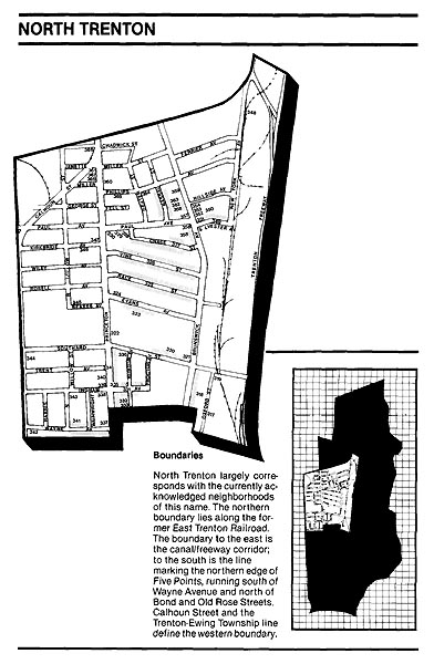
NORTH TRENTON
History and Development
Most
of North Trenton has been part of the City of Trenton since incorporation
in 1792. Narrow strips of land to the north and west, originally part of Ewing Township, were annexed in 1900. Early landowners included
the Heath, Lambert, Cadwalader and Beakes families. 1
The Nathan Beakes estate
was the earliest and best known settlement in the area, dating from Revolutionary
days. Beakes Lane ran from Five Points to the Beakes
house, which was located near the present intersection of Princeton and Beakes
Avenues. After the formation of the Princeton and Kingston Branch Turnpike
Company in 1807, the Princeton Pike followed the line of Beakes
Lane. The Brunswick or Old Maidenhead Road traversed the area to the east.
2
Despite this early estate and the highways, North Trenton developed slowly. The areas low and swampy terrain partly explains this phenomenon. A development pattern persisted, as large tracts of North Trenton land were utilized for special purposes, part cause and part effect of slow settlement.
In 1802 a tract of higher land on Brunswick Avenue
was purchased from Nathan Beakes to be used as a
Potters field for burial of the poor. The Potters Field cemetery later
became known as Gallows Hill after a number of
alleged hangings, including that of a confederate spy. It officially became
the City Cemetery in 1861, retaining a ghostly reputation.
Relatively solid land was used as pastureland. A number
of tracts served as military paradegrounds. Land
opposite the Beakes homestead was utilized in 1847
as a camp and training ground for Mexican recruits. Because of its outlying
location and available unsettled land, charities such as the Almshouse, established
in 1869, were located in the neighborhood.
The Hotel de Kelly was a disreputable structure (sic)
dedicated to the housing of tramps. 3 Tickets
were distributed to transients at City Hall, redeemable for bed and breakfast
after the long trudge to Kellys on Brunswick Avenue (at Race Street). It
was not mere coincidence that Kellys stood adjacent to the Potters Field.
It is said that noise and fisticuffs were common in the area. With the Almshouse,
Gallows Hill and the Hotel de Kelly, it was a somewhat eerie
neighborhood. 4
Industry
After
the construction of the Delaware and Raritan Canal,
the area attracted industries that required much space. This type of activity
included Wellers boatyard and basin established
east of Brunswick Avenue.
The boatyard of Hiram Weller
& Sons handled jobs ranging from contracts for repair of most barges and
schooners on the Delaware and Raritan Canal, to
construction of palatial yachts for local gentlemen sailors. They concurrently
ran a sand and gravel business, and built dozens of flagpoles, especially
during wartime. The Wellers basins were generally
well-stocked with barges and yachts, a few fish, and skinny-dipping neighborhood
boys. 5
H.C. Kafer
& Co., Brick Manufacturers, was also situated at Princeton Avenue and
Kirkbridge Street. They manufactured all kinds of building
and paving brick making a specialty of pressed and fancy brick, grinding and
fitting arch brick. 6 Founded in 1847, this
was the North Wards largest and most prominent brickyard, providing brick
for New York, Jersey City, and other growing municipalities, as well as the
home market: The office of the H.C. Kafer
& Co. brickyard still stands at 1001 Princeton Avenue (#347). A small
cubic one-story Italianate structure with bracketed
cornice on all sides, it has the appearance of a patternbook
design.
The former Jonathan Bartley
Crucible Co. complex (#317) on Oxford Street illustrates another example of
North Trenton industry. One of the structures is surmounted by three decorative
crucibles, a direct physical reminder of Trentons pottery prominence. Despite
the presence of industries, most nineteenth century Trentonians
perceived North Trenton as the large picnic grove of the Evans farm, or simply
as a sparsely settled outlying district along the Princeton and Brunswick
Roads, a territory to be passed through while traveling to points north. The
most commonly expressed concerns about the area included the lack of lamp
posts and the poor road conditions. 7
Rose Cottage Nurseries supplied Trentonians
with assorted flowers which complimented this country-like setting. Owned
by noted floraculturalist George Wainwright,
the nurseries occupied sizeable acreage west of Princeton Avenue and offered
a rare variety of imported Japanese tree, the Japanese Salisburia
Bibola, or the Ginkgo. 8
Residential Development
Eventually North Trenton residential development in the 1880s proceeded in larger segments than elsewhere in the North Ward. Initially dwellings had been scattered about the area throughout the nineteenth century. More systematic development followed later, often taking the form of rows where an entrepreneur erected a series of dwellings of the same or interrelated design. Repetitive detached rows were built by Henry Phillips at 3-37 Chase Street, (#327) and Samuel B. Packer along Brunswick Avenue (#318) and Southard Street (#320).
Packer Row is a particularly notable late nineteenth
century example. The Packer Row structures provide a striking pattern along
the slight rise of Brunswick Avenue (#318). Each building, whether twin or
freestanding, two stories or three, is articulated by a continuous stone band
at sill-level, segmentally arched lintels with incised
floral motif, and a bracketed cornice.
Along Brunswick Avenue, Southard
and Oxford Street, fourteen three story twins, three simpler three story twins,
five three story row houses, a store, and a tavern were all built by Samuel
B. Packer. (#318, #319)
By the 1890s residential development from downtown
along Princeton Avenue to the Almshouse in 1887 contributed to this development.
Henry P. Phillips purchased the cemetery site and carted away the remains,
to develop Chase Street. Subsequently, Joseph Paul opened Paul Avenue. After
1892, the trolley from downtown traversed this street, passing from Princeton
Avenue to Brunswick Avenue, then continuing northward. 9
A variety of architectural styles characterize this
residential area. Number 689 Princeton Avenue (#340) is possibly the oldest
residential structure in North Trenton; its austere form and sparse ornamentation
recalls Federal style architecture. Freestanding or twin residences exist
in a cluster at Brunswick and Paul Avenues. This grouping includes freestanding
and twin Italianate homes raised on a terrace (#358,
#359); a hip-roofed cubic house with Italianate detailing but a Greek Revival demeanor; a large
Queen Anne twin with wood shingles (#352), a Queen Anne house with sunburst
motifs and a uniquely detailed projecting side bay (#353); and a three unit
structure in bungalow style (#354). Around the corner on Sylvester Street,
a three unit Victorian Gothic structure features original weatherboards
and gingerbread detailing on one of its units (#350). This residential cluster
encompasses great stylistic variation and character on an elevated site at
the former bend of the Brunswick Avenue/Paul Avenue trolley line (#349).
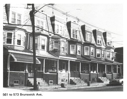
Just south of this cluster, 561-573 Brunswick Avenue
is a row of seven Queen Anne/Basic Block houses with unusual truncated dormers
(#355). Other examples of North Trentons distinctive series of attached houses
are 666-684 Southard Street (#320) with a continuous
metal cornice, and 1249-1259 Princeton Avenue (#367), a composition of six
interdependent units united by paired gables and parapets.
Just as in other areas and neighborhoods, construction
of the trolley line and of new schools prompted a strong tide of improvements
with building in leaps and bounds in the hands of land associations and
individual developers. 10 Approximately 200
dwellings were constructed more or less simultaneously along Vine and Race
Streets and Evans Avenue. These streets reflect the common North Ward tradition
of connecting major north-south arteries (Princeton and Brunswick Avenues)
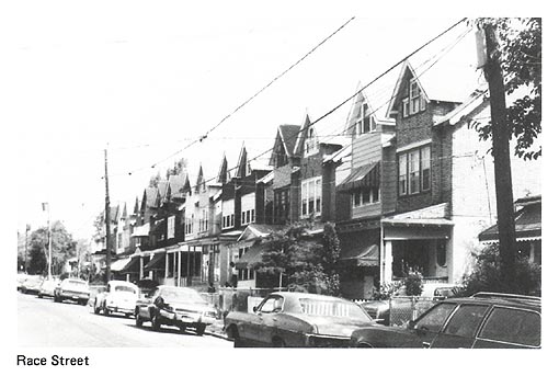
with long, continuous east-west streets. Vine Street (#326) has unusual rowhouses with bungalow detailing; Race Street (#325) is lined
with simple but dignified brick twins; Evans Avenue (#323) has Basic Block
twins; Princeton Avenue (#332-340) between Southard
Street and Wayne Avenue includes brick row houses in long series and alternating
variations on the Basic Block style. Large scale development reappeared in
the 1940s and 1950s public housing projects between Princeton Avenue and
Calhoun Street.
Institutions
Perhaps
because of its relatively late residential development, North Trenton does
not boast many long-standing community institutions. Dating from 1919, St.
James Catholic Church (#330) is the most prominent ecclesiastical establishment.
The Helene Fuld Hospital (#360) is a rambling complex,
originally built around one of the areas stately mansions.
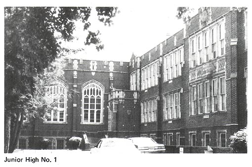
North Trentons Junior High School No. 1 (#322) is
a notable institution, with its elaborate Collegiate Gothic stone detailing
and its imposing structure. Following a comprehensive school system reorganization
in the early twentieth century, it was established as Trentons first Junior
High School. Junior High No. 1 and the Jefferson Elementary School (#321)
were constructed on the Almshouse site, maintaining much open acreage.
Today
the North Trenton area retains its characteristic blend of diverse styles
of residential, commercial, and industrial areas.
1 See Map of City of Trenton
Showing Territorial Growth, 1792-1928, Walker, et. al., A History of Trenton, p.
352. (Figure 7 of this study.)
2 Walker, et. al., A History of Trenton, p. 241.
3 Meredith Havens, Trenton
in Bygone Days: North Trenton Area 80 Years Ago Was Bleak Section Noted For
Hotel For Tramps, City Poor Farm and Potters Field; Trenton Sunday Times-Advertiser, September 30, 1962, (Trenton in Bygone Days, vol. 13, p. 60).
4 Havens, Trenton in Bygone
Days: North Trenton . . . :
5 Harry J. Podmore, Head of Town; State Gazette, May 10, 1920.
6 H.C.
Kafer & Co. Brick Manufacturers, State Gazette, July 31, 1897, (Scrapbook of Trenton Industry).
7 Harry J. Podmore, Trenton in Bygone Days; Trenton Sunday Times-Advertiser, October 26, 1948.
8 Harry J. Podmore, Head of Town; State Gazette, February 13,
1922.
9 Trenton Free Public Library,
Trentoniana Collection, Vertical File: Street Railways.
10 John J. Cleary, Memorable Yesteryears for Trenton, No. 33, Trenton Sunday Times-Advertiser, 1917, (Memorable Yesteryears for Trenton, vol. 2).
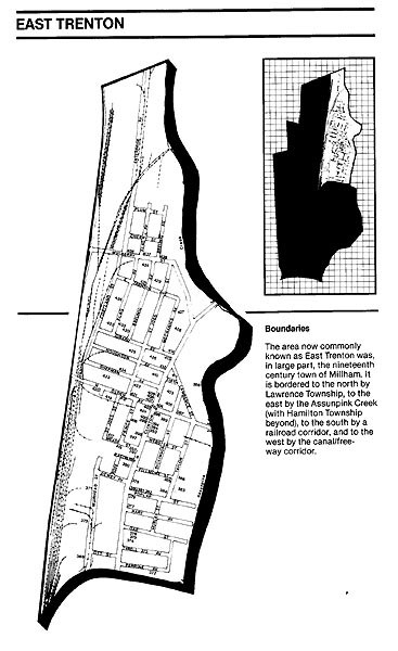
EAST TRENTON
History & Development
When
the City of Trenton first incorporated in 1792, its boundaries included the
neighborhood known as East Trenton. However, in 1844, Lawrence Township annexed
this area. It remained part of Lawrence Township until 1882, when East Trenton
became an independent jurisdiction known as Millham
Township, which included much of Top Road. On May 1, 1888, Millham
once again became part of the City. of Trenton. 1
In the mid-eighteenth century, Thomas Cadwalader owned much of Millham
Township, but it was Samuel Henry who first improved the area, building a
grist mill and planting a two hundred sixty tree apple orchard. Henry sold
his own country estate during the late 18th century to General Philemon
Dickinson. By 1797, when the estates eastern portion was sold, the property
included the grist mill, a saw mill, two houses, a drygoods
shop, a blacksmith shop, a kiln, a barn, stables, and 1500 fruit trees. 2
Dickinsons son Samuel retained part of the property
in East Trenton as a country estate, constructing a stone house in 1792 known
as The Grove, (#414) which still remains today, and is the oldest standing
building in East Trenton. Located at North Clinton and Girard
Avenues, The Dickinson House was described in 1809 as an excellent stone
dwelling house, 43 by 30 feet, in which there are two large parlors, the ceilings
of which are 13 feet high . . . 3 The house
retains its original character today despite its change in use, first as a
YMCA and later as a branch library. It no longer commands a sizable estate,
but its large lot retains enough foliage to justify its historic name, The
Grove.
Upon his fathers death in 1809, Samuel Dickinson moved
his permanent residence to The Grove. Samuels son John attempted to initiate
an industry by cultivating silkworms and planting many mulberry trees along
the roads, especially along what is now Mulberry Street. His efforts to produce
a cash crop met with little success. 4
Despite
John Dickinsons difficulty in establishing a successful commercial venture,
industry did arrive on the scene. By the early 19th century, the industrial
revolution began to have an impact on the area. Millhams
industrial development depended upon and was molded by its transportation
routes. Many mills were built along the Assunpink
Creek. Industrial buildings were constructed along these routes by the 1840s
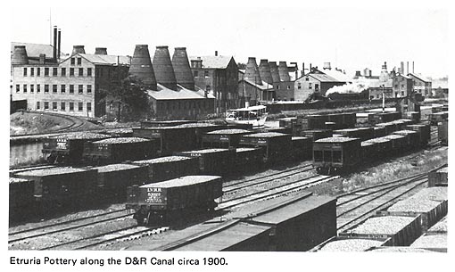
and during the 1850s the areas pottery industry began to emerge.
The 1860s and 1870s witnessed the incorporation of
many pottery and rubber companies. The potteries,
manufacturers of products ranging from fine china to sanitary porcelain, tended
to locate near the canal, while the rubber companies scattered along Millham Road and the Assunpink.
The Delaware & Raritan Canal which opened in
1838 defined the areas western edge, creating a new industrial corridor.
The canal, the neighboring Camden & Amboy Railroad
line and Millham Road (North Clinton Avenue) to the east, all parallel
to each other, established a developmental framework. By the 1880s a visitor
to this section of Trenton reported for Harpers New Monthly Magazine:
A two hours ride from New
York by rail takes one to Trenton, in point of production the principal seat
of ceramic manufacture in the United States. As the train enters the suburbs
one catches a glimpse of groups of substantial new buildings, whose ruddy,
flame-colored cones proclaim the great industry is striking its roots outward
from the center with its crowded factories and its network of railways and
canals. Reaching the eastern portion of the city, one is surrounded by telling
signs of the peculiar activity which has appropriately given this region its
title of the Staffordshire of America. On every
side may be seen smoking chimneys and kilns looming above tall modern factories
or long, low, weather-stained buildings, lumbering carts filled with casks
and crates of finished wares.. 5
East Trentons physical character explains why this area
is known as The child of industry. Numerous two and three story brick industrial
buildings dating largely from 1880-1920 border the area. These include the
structures and complexes of the Lenox Co., (#417)
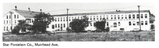
the Star Porcelain Co., (#371) the Circle F Manufacturing Co., (#415, #416)
and the John Taylor Co. (#372) (meat products). The oldest buildings of the
Lenox complex (originally built for the Ceramic
Art Co.), were designed to allow for conversion to housing should the pottery
venture fail. The complex has been expanded to include an elegant structure
with an exposed concrete frame. The Hamilton Rubber Co. buildings, (#415,
#416) presently occupied by Circle F Manufacturing Co., are a rhythmic architectural
composition of gabled 1870s structures united by a gracefully curvilinear
wing with an Art Deco character. The John Taylor Co. buildings (#372) are
surmounted by ornate brick and terra cotta cornices.
Land Sub-Division
& Housing
The
areas growing industry led to a breakup of large estates such as the Dickinsons,
offering an opportunity for land subdivision and providing housing for factory
employees. As early as 1850, land developers subdivided property into building
lots, running three streets from the Millham Road
to the Assunpink Creek (Hart Avenue and Poplar and
Oak Streets). These lots became known as Homestead Place. In 1851, fifty five
lots were laid out on a portion of the former Dickinson estate and were sold
for twelve to twenty five dollars. 6 Real
estate activity eventually culminated in the formation of land associations.
The first well-directed effort
to induce the purchase of lots in Millham, and the
settlement thereon of such persons as it was deemed would exert an influence
toward developing the various interests which have since made the locality
conspicuous, was put forth by the East Trenton Land & Building Company,
which was incorporated April 6, 1866 . . . 7
The Enterprise Land Co. of New Jersey, organized in 1873, also developed land on both sides of the canal.
Such
associations promoted development through the subdivision and sale of lots.
Occasionally the associations constructed speculative housing. In a distinctive
instance, Three double frame dwelling houses were erected on Klagg Avenue as an inducement to the buyers of lots, for whoever
drew a lucky number found a home already built on the lot. 8
Although residential and industrial construction continued, many years passed
before the communitys dense physical character emerged on a patchwork of
separately developed non-coinciding grids. While the view along residential
Eastburn Avenue (#390) epitomizes the overshadowing presence
of industrial buildings and smokestacks, many residential streets are far
removed from industrial properties.
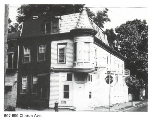
Community Life
& Institutions
Practical
reasons required many families to live near industrial sites. One area resident
recalled her childhood in the neighborhood during the 1870s. Her father,
a chemist, worked in one of the potteries, mixing
chemicals for glazing. Since he had to be present when the glaze kilns were
run off at night, the family lived near the factory in the heart of the
potters community. Life among the pottery workers, was rough Our surroundings
were anything but pleasant . . . Gambling, fighting, drinking were done to
excess . . . 9
Corner taverns and saloons were often focal points
of community life. Homestead House (#378), at the corner of North Clinton
Avenue and Poplar Street, opened in 1860 as Millhams
first public house. Nearby at North Clinton Avenue and Meade
Street stood The Princess; one of Trentons few neighborhood theaters (#392).
Featuring decorative tilework and monumental metal
cornice, the building has served as both The Princess Theater and The Holy
Cross Church. The neighboring wood and metal Holy Cross Diner (#391) luncheonette
is a very early type of roadside diner.
Despite the increased number of area factories, the
neighborhood retained recreational space. The grounds of the larger brewery,
known as Locust Hill and later Hetzels Grove, were
just across the Assunpink Creek above Olden Avenue
(#388). These grounds were the scene of picnics and shooting matches as well
as grand balls. A swampy meadow between Courtland
Avenue and the railroad saw much activity. In the summer residents raised
geese and ducks and pastured horses, mules, cows, goats and swine. In the
fall they gathered hazel nuts and chestnuts, and in the winter, the swamp
was partially ice-covered creating a grand skating park. 10
Millhams settlers followed the national
pattern of immigration and settlement in the northeast. The first groups included
the English, Irish, Germans, and Scotch. Later, during the 1880s and 1890s
when American industry expanded, many Italians and Polish people joined the
community. In more recent years, Black and Puerto Rican workers found employment
in area factories. 11 Throughout these years,
the communitys fortunes have depended upon area industry.
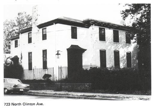
Community institutions also contributed to the neighborhoods
development. A Black cemetery was established at an early date along the Assunpink
Creek between Hart and Oak Avenues. The first church in East Trenton, Methodist
(#377), was organized in 1852 at Hart
and Clinton Avenues. The first school opened in 1866 on Dickinson Street.
Other churches and schools followed. Today, St. Josephs Catholic Church (#421,
#422), the East Trenton Presbyterian Church (#407), and the Methodist, now
the First Born Church of the Living God (#377) are the most physically prominent
existing neighborhood churches.
Commerce
By
the 1880s, Millham was a thriving community with
growing industry, expanding population, increasing housing, and the beginning
of a commercial district along North Clinton Avenue. The opening of a street
railway in 1876, which connected the area to downtown Trenton, especially
assisted the neighborhoods growth. The developing commercial area, along
a one-and-a-half mile stretch of North Clinton Avenue, eventually accommodated
over one hundred businesses including grocers, restaurants, shoe repair shops,
furniture companies, and two department stores. 12
A number of distinctive building types and patterns
emerged along commercial North Clinton Avenue. The intersections of North
Clinton Avenue with Girard and North Olden Avenues,
boast picturesque Queen Anne structures with corner entrances and turrets.
Number 699 North Clinton Avenue (#413)
is frame, while the later 577 (#402) is brick with terra cotta panels.
More common commercial structures are blockish Italianate buildings. Often featuring drip molds, these buildings
rise above their neighbors anchoring corners.
Other parts of North Clinton Avenue are enlivened by
an extraordinary variety of rounded, rectangular and three-sided projecting
upper story oriels. Today, many of the once busy commercial buildings are
used for storage, but meat and vegetable markets, a used furniture store,
and additional small businesses still remain.
Notes
1 See Map of City of Trenton
Showing Territorial Growth, 1792-1928, Walker, et. al., A History of Trenton, p. 352.
2 William J. Harney, Old Millham Notebook,
Trenton Sunday Times-Advertiser, August
4, 1929, (Trentons First Potteries and Old Millham Notebook, p. 72).
3 Harney,
Old Millham Notebook, Trenton Sunday Times-Advertiser, August 4, 1929.
4 Walker, et. al., A History of Trenton, p. 314.
5 Hazel Herman, Millham: Trentons Modern Industrial Cradle; Trenton, June, 1970, p. 21.
6 William J. Harney, Old Millham Notebook;
Trenton Sunday Times-Advertiser, August
11, 1929, (Trentons First Potteries and Old Millham Notebook,
p. 9).
7 Major E.M. Woodward and John F. Hageman, History of Burlington and Mercer Counties (Philadelphia:
Eyerts and Peck, 1883), p. 359.
8 Harney,
Old Millham Notebook, Trenton Sunday Times-Advertiser, August 25, 1929.
9 Lillian C. McKee, How We
Spent Our First Ten Years in Trenton; (Trentoniana
Division, Trenton Free Public Library, Trenton, N.J.)
10 William J. Harney, Old Millham Notebook;
Trenton Sunday Times-Advertiser, August
18 & 25, 1929, (Trentons First
Potteries and Old Millham Notebook,
pp. 11, 13).
11 Trenton Council of Social
Agencies, A Study of Northeast Trenton, April, 1958.
12 Decline and Fall: Along Once
Thriving North Clinton Avenue Vacant Buildings Paint a Somber Picture; Trenton Times, May 12, 1971.
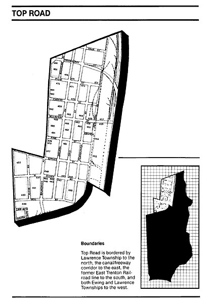
TOP ROAD
History &
Background
The
Top Road area has undergone many boundary changes since its incorporation
into the City of Trenton. Trentons southeastern corner was severed in 1858,
becoming a part of Ewing Township. In 1900, however,
it was reannexed, and additional lands to the west
accompanied the change. Initially the larger and northern portion of Top Road
belonged to Hopewell and Maidenhead Townships, until Millham
Township adopted this land in 1882. The City of Trenton annexed Millham in 1888. 1 However,
to appreciate Top Roads evolution this chapter must begin its study with
the late 17th and 18th centuries.
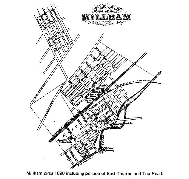
While
Trenton grew during the eighteenth century, what was later to be known as
Top Road lay in the country as part of the path northwards to Princeton and
New Brunswick. In fact, as early as the late seventeenth century, a path had
been cut from Indians Ferry on the Raritan (New
Brunswick) to the Falls of the Delaware: By the mid-eighteenth century,
this path became the route of countless stages providing service from Trenton
to New Brunswick and beyond to New York. In 1758, Mill Lane was laid out
to facilitate transportation of grain between farm country and the mills of
Samuel Henry on the Assunpink Creek. The lanes
intersection with the road to New Brunswick was marked by a tavern known as
the White House or Bellerjeaus Tavern. It stood
alone, far out in the country at that time, in service to weary travelers
and thirsty farmers. 2
A second structure mentioned in early historical accounts
was a distillery known as the Still House which lent its name to the area
where Mill Road later crossed the Delaware and Raritan
Canal. Neither of these early structures remains. However, the oldest extant
structure in the area, a small plain twin dwelling dating from the mid-nineteenth
century, survives as a tavern near the Still House crossing. The Mill Lane
was relaid in 1774 as a four-rod road, and became
known as Mulberry Lane (Street), owing to John Dickinsons experiment in East
Trenton with the silk industry and mulberry trees.
In 1804 the Trenton and New Brunswick Turnpike Company
was chartered to improve the Trenton-New Brunswick Road. Some years later,
it was rebuilt above Mulberry Street, to be used possibly as a railroad right-of-way,
and the road became renowned as one of the straightest roads in the country.
In 1807 the Princeton and Kingston Branch Turnpike Company was chartered to
develop a road to Princeton, to the west of and parallel to the New Brunswick
Pike. 3
The Brunswick and Princeton Pikes and Mulberry Street
provided the basic framework for the future development of Top Road which
commenced in the 1860s. In addition, the Delaware and Raritan Canal, constructed by this time along what is now
the neighborhoods eastern edge, provided a corridor for industrial development.
Residential Development
The subsequent dispersal of activity and use from the downtown and the successive increases of population prompted the Citys Enterprise Land Co. to purchase and later build a substantial amount of housing for new residents. Development proceeded slowly until the City grew outward toward the north. Except for Top Roads southwest portion, the areas residential development occurred largely in terns of individual lots, with many intervening lots remaining vacant.
The first houses, built before 1880 and standing in
the 900 block of New York Avenue (#455) opposite the potteries,
are simple and austere two story Greek Revival /Italianate
hybrids. A few frame workers cottages remain with generous setbacks. A variety
of later vernacular housing styles, including the Italianate/Gothic
and the Basic Block, are represented. Numbers 821-825 Mulberry Street (#468) is a fascinating variation on the common
Italianate/Gothic theme: a four unit structure with
pedimented window hoods and bargeboards
with circular drops and cutouts. Streets such as the 600 and 900 blocks of Ohio Avenue (#439, #462), and the 700 block of Mulberry Street
(#465) are lively and colorful architectural compositions. Although most styles
utilized are much the same as elsewhere in Trenton, in Top Road they appear
in a less dense context in small clusters of freestanding form.
The housing stock also includes a number of more suburban
structures. Number 804 Plum Street (#474) is a handsome cottage combining
Shingle Style and bungalow elements.
Repetitive development and greater density characterize
the southwest section of Top Road. However, even the repetitive development
on the small lots of Heil Avenue, 0-100 block (#450),
consists of narrow freestanding bungalows. Later, during the early twentieth
century, the North Trenton Land Company and the Brunswick Heights Land Association
purchased and resold major portions of property to the west. 4
At the same time, a number of potteries were erected
on the western bank of the canal. Most of the potteries
are composed of long, low, brick structures with gable roofs and/or raised
skylights.
Top Road developed a strong community focus
akin to that of a small town. Although the areas early roads provided the
framework for the growth of Top Road, the intersection of North Olden Avenue
with Brunswick Avenue provided a setting for neighborhood businesses and organizations.
Many early Top Road households were Polish, and this ethnic presence continues
today, manifested in both shops and institutions.
In 1904 Polish Catholics organized a parish and named
it St. Hedwigs, honoring the thirteenth century
patron saint of Selicia, part of the territory of
Poland. A massive twin towered church was constructed in 1924 at the corner
of Brunswick and North Olden Avenues (#445). The complex of church, school,
convent and auditorium (#443, #444, #445) dominates the area. Polish Lutherans
established a church, Holy Trinity, in 1911.
In 1906, Kosciuszko Hall
(#441) was constructed at North Olden and Ohio Avenues. This large hall, honoring
the Polish hero of the American Revolution, serves as a Polish/American community
center, and as Hall No. 59 of the Polish fraternal organization. 5
The Eagle Bakery is situated across Ohio Avenue from
Kosciuszko Hall (#440). A carved stone Polish Eagle
is set between the facade attic windows, S. Markiewicz
is set in tile on the floor of the entrance stoop.
The industrial complexes which foreshadowed Top Roads
growth are concentrated along its eastern edge. The buildings of the community
core present a varied stylistic profile, a mixture of the Neo-Classical, Italianate
and twentieth century brick commercial beneath the Baroque towers of St. Hedwigs.
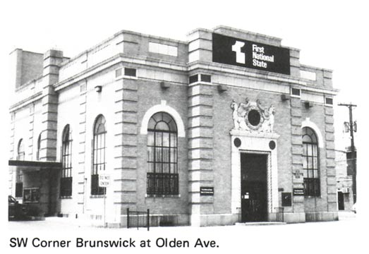
Two structures in the neighborhood feature fanciful
distinctive detailing. The First National State Bank (#447) at Brunswick and
North Olden Avenues displays two large and fearsome stone griffins carved
in relief. Number 958 Pennsylvania Avenue (#460)
is a whimsical essay in a highly personal Victorian Neo-Classical style.
Introducing the orange and turquoise house, a gateway consists of pedestals
adorned with plaster plants.
Despite the industrial corridor to the east, and a
more concentrated residential pattern toward the southwest, Top Road is characterized
neither by overshadowing industry nor dense residential development. It has
retained its green, spacious, small town character; the homes porches and
gardens, features found more frequently here than elsewhere in the North Ward,
certainly contribute to this suburban quality.
Notes
1 See
Map of City of Trenton Showing Territorial Growth, 1792-1928,
from Walker et. al., A History
of Trenton, p. 352. (Figure 7 of this study)
2 Harry
J. Podmore, Head of Town, State Gazette, January 5, 1920.
3 Walker
et. al., A History of Trenton, p. 241.
4 Land
Development Map.
5 Trenton Free Public Library, Trentoniana Collection, Vertical File: Foreign Populations.
A
buildings style is the key to its character, and therefore essential to its preservation. Every building possesses
a special style which results from the collection and arrangement of its architectural
elements. These range from the structures proportion and massing to its detailing
and ornamentation. The specific features vary in scale, material, texture
and form, but combine together in a unified architectural composition that
creates a buildings unique style. Although products of their time, stylistic
themes do not emerge instantly on a particular date, nor do they suddenly
disappear. Instead, they evolve gradually, reach a climax, and fade away.
As they evolve, elements associated with different
styles are sometime combined to form buildings that are hybrids. Upon occasion,
a building of one style is updated with elements characteristic of a later
period. Regional adaptations and local influences also account for variations
of a particular style.
The various styles prevalent throughout the North Ward
include Greek Revival, Italianate, French Second
Empire, Victorian Cottage, and the Basic Block. Other, less prolific styles
are listed in the glossary.
Greek Revival
The
Greek Revival style is part of an architectural movement whose buildings
features are rich with associative values, recalling a distant time or place.
Although the Greek Revival derived from the architecture of Classical Greece,
its style does not represent an actual and accurate revival but rather a romantic
interpretation. In the late eighteenth and early nineteenth centuries, this
civilization and its architecture received the focus of public attention.
Archeological expeditions produced lavishly illustrated books and sparked
excitement with the culture and artifacts of ancient Greece. The Greek War
for Independence from the Turks (1821-24) also evoked international sympathy.
People increasingly viewed Classical Greek architecture as an expression of
the democratic ideals associated with its ancient civilization. Americans
deemed the mode especially appropriate for the architecture of our own young
democratic nation, itself only recently freed from foreign domination.
The Greek Revival style, evident throughout Trenton,
prevailed from 1825 to about 1850. Once found in long uniform rows, today,
Greek Revival homes survive only in pairs or triplets. The dignity of these
buildings derives from the simple and straightforward character. A lack of
ornamentation and a regular boxlike silhouette typifies
the homes built in this mode. In Trenton, Greek Revival homes generally possess
two and one half story wood clapboard or brick facades which feature three
bays or openings. To one side of the front facade, at the head of a simple
stoop with wood or wrought and cast iron railings, is the entry way. The doorway
usually stands unadorned although sometimes bears classical details or orders.
A two or four panel door is topped by a rectangular transom or overlight. A more elegant doorway variation may feature simple
sidelights. Window treatment of six over six paned, double hung sash with
unadorned stone or wood sills and lintels, contributes to the character of
these unelaborate homes. Shutters grace the major
windows. Although today people consider shutters ornamental, operable shutters
formerly performed important functions. On the ground they were paneled to
provide security while at the second level they were louvered to allow ventilation
while still offering protection. The shallow top floor or attic, defined by
the fascia board, is lighted by knee windows. The openings are perhaps the
most distinguishing feature of the Greek Revival facade. Above these openings
may be elaborate cornices featuring a row of blocks called lentils. A shallow
cable or flat, shed roof caps the entire structure.
Italianate
The
Italianate style is opulent, inspired by the architecture
of Renaissance Italy. It originally appeared in English and French public
buildings during the 1830s. Within a decade it started to appear in the United
States. John Notman, an architect responsible for
many buildings throughout the northeastern states, has often received credit
for its American introduction. His design for the Athenium
in Philadelphia exemplifies the Italianate style
used in urban structures; his design for Ellarslie
in Trenton represents a rural version.
By 1850, the Italianate had
supplanted the Greek Revival in Trenton. Its general forms, massing and characteristics
features create a dramatically different style from its predecessor. Italianate
buildings are not severe, but quite lavish. Technological advances helped
to create the elaborate embellishments that characterize this ornamental style.
Typically, the smooth stucco facades of these two and
one half or three story houses are approximately equal in height and width.
Segmental and semicircular arched openings, adorned by elaborate hood molds,
and richly incised lintels, have replaced the plain, rectangular openings
of the Greek Revival. The doorway, the design focus, is recessed and often
features double hung doors decorated with rich moldings and circular or oval
motifs. Tall windows (sometimes full length) no longer feature many panes
of glass, but instead contain large two over two double hung sash. The styles
exuberance sometimes thrusts forward to the street with large bay windows.
A broad cornice crowns the entire composition. This cap features small attic
windows nestled under the overhanging eaves supported by large brackets. Either
paired or evenly spaced, these protruding brackets add substantial depth and
interest to the facade.
French Second Empire
The
French Second Empire or Mansard style borrowed the architecture of mid nineteenth
century Paris. Emperor Louis Napoleons reign (1852-70) witnessed the transformation
of Frances capital from a medieval maze of narrow streets to a city of grand
boulevards and lavish monumental buildings, setting the standard for Europe
and America. By the late 1860s, Americans had widely adopted the French Second
Empire style. It gained popularity in Trenton, lending itself particularly
to elegant rows and stately semi-detached homes.
The mansard roof is the hall mark of the French Second
Empire Style. Named after French Imperial Architect Francois
Mansard, its characteristic roof is the styles dominant element. Resting
on a small bracketed cornice, the steeply pitched, nearly vertical roofs may
be either straight or bowed. Dormer windows provide light and air to the attic
rooms created by the mansard. Delineating the composition, the roof is often
topped with decorative cast iron called roof cresting. Roof tiles are frequently
slate, sometimes featuring multi colored and semi circular or hexagonal tiles.
Three-sided projecting window bays, balanced on either
end of a semi-detached house, add depth to the facade while maintaining a
dignified symmetry. The fenestration throughout usually consists of simple
rectangular frames with two over two sash. In many cases, however, the windows
feature rounded top rails and hood molds reminiscent of the Italianate
and Neo-Grec Styles. Similarly, the front entries
of these French Second Empire homes feature elaborately panelled,
recessed, and arched double doors. Many of these French Second Empire houses
were originally flat-roofed Italianate houses. The
addition of a mansard roof to these nineteenth century homes provided an additional
story, while making the home fashionable.
Victorian Cottage
The
Victorian Cottage is a vernacular house type which does not have a specific
high-style counterpart. It is ultimately derived from the gabled, brick attached
workers houses of eighteenth and nineteenth century English mining and industrial
towns. In America, the narrow two room per floor plan was adopted for urban
rowhouses, and the gabled cottage form was popularized
for free-standing rural gothic cottages by A.J. Downing and others after
1840. Under the additional influence of temple-form Greek Revival cottages,
builders later in the century reunited this plan and gabled form as the frame
Victorian cottage.
These modest cottages were well-suited for modest lots,
and were often among the first houses constructed in the outlying areas around
expanding cities because they could be easily and quickly constructed by a
builder or landowner. Many of Trentons neighborhoods feature small numbers
of Victorian cottages erected between 1870 and 1900. Although often hemmed
in on their small lots by adjacent rowhouses, the
cottages also invariably reflect a measure of their rural cottage roots with
a setback behind a small yard fronted by iron fencing.
The Victorian cottage is a narrow two or three bay
house with balanced fenestrations, of two stories,
with its vertical lines accentuated by a street facing gable roof. Most cottages
have porches, sometimes with turned columns and wood carpenter gothic detailing.
All were originally clad in weatherboards, with
corner and bargeboards.
Basic Block
The
term Basic Block has been coined to correspond with a common Trenton vernacular
house type of the early twentieth century which has no commonly accepted stylistic
name. The Basic Block structure, almost always a twin, draws from Queen Anne,
Colonial and Georgian Revival, and Bungalow sources, but retains no dominant,
specific stylistic character. Rather, its identity lies in its shape and consistent
adjunct features.
The Basic Block twin has a primary, somewhat bulky,
squarish form. It is capped by a hip roof or a broad gable
parallel to the street. Porches, projecting three-sided or rectangular second-floor
bays for each unit, and either individual or shared dormers are the essential
supplementary characteristics. It can be either brick or frame. Stylistic
detailing appears irregularly. Queen Anne influence is sometimes apparent
in the treatment of projecting bays and in the use of a variety of sheathing
materials, the colonial and Georgian Revivals may be reflected in occasional
planar brick facades, neoclassical porch columns, and hip roofs; Bungalow
characteristics appear as shingling, exposed rafters, and porch detail.
Basic Block twins are constructed throughout Trentons older outlying residential neighborhoods between about 1900 and 1930.
1. Delaware & Raritan
Canal
2. Calhoun
Street Bridge
3. Peace Street Bridge
4. South Broad Street Bridge
5. 120 South Stockton Street
6. Bridges @ U.S. Route 1 &
East State and Perry Streets
7. 330-334 East State Street
8. 319 East State Street
9. 228-244 East State Street
(north side)
10. 227 East State Street
11. 225 East State Street
12. 223 East State Street
13. 201 East State Street
14. 216 East State Street
15. 143 East State Street
16. 137 East State Street
17. 135 East State Street
18.127-129 East State Street
19. 125 East State Street
20. 117-121 East State Street
21. 109-113 East State Street
22. 150 East State Street
23. 120 East State Street
24. 35 East State Street
25. 9 East State Street
26. 98 East State Street
27. Dunhams Watertower @ 11 North Broad Street
28. 12-14 East State Street
29. 2-6 East State Street
30. 7 West State Street
31. South Warren Street (west side just below West
State Street)
32. 7-41 West State Street (south side)
33. 9 West State Street
34. 27 West State Street
35. 28 West State Street
36. 31 West Front Street
37. 31-33 West Front Street
38. 31 West Front Street (rear lot)
39. 6-21 Peace Street (both sides)
40. 16-46 West Lafayette Street
41. 15 South Broad Street
42. 2 North Broad Street
43. 12 North Broad Street
44. 22 North Broad Street
45. 102 North Broad Street
46. 101-109 North Broad Street
47. 137 North Broad Street
48. 143-151 North Broad Street
49. 153 North Broad Street
50. 25 East Hanover Street
51. South Warren and Lafayette Streets Lamp Post/Street Sign (throughout
City)
52. 110-130 S. Warren Street
(east side)
53. 120 South Warren Street
54. 101-123 South Warren Street
(west side)
55. 101 South Warren Street
56. 8-32 South Warren Street
(east side)
57. 2-24 North Warren Street
(east side)
58. 14 North Warren Street
59. 18-24 North Warren Street
60. 35 North Warren Street
61. 102-116 North Warren Street
62. 120-122 North Warren Street
63. 124 North Warren Street
64. 130 North Warren Street
65. 140 North Warren Street
66. 123-127 North Warren Street
67. 131-137 North Warren Street
68. 139 North Warren Street
69. 151 North Warren Street
70. 153 North Warren Street
(facing Chancery Lane)
71. 8 West Hanover Street
72. 35 West Hanover Street
73. 41 West Hanover Street
74. 49 West Hanover Street
75. 60 West Hanover Street
76. 128-130 North Willow
77. 28-32 Bank Street
78. 10-14 Bank Street
79. 211 North Warren Street
80. 221 North Warren Street
81. 227-231 North Warren Street
82. 233-235 North Warren Street
83. 237-245 North Warren Street
84. 220 North Warren Street
85. 222-228 North Warren Street
86. 230-232 North Warren Street
87. 234-236 North Warren Street
88. 238-240 North Warren Street
89. 242-246 North Warren Street
90. 250-256 North Warren Street
91. 335-349 North Warren Street - 3 Pennington Avenue
92. 339 North Warren Street
93. 8-12 Perry Street
94. 16 Perry Street
95. 215-237 North Broad Street
96. 245 North Broad Street
97. 230-246 North Broad Street
98. 200 Block North Broad Street
99. E.L. Kerns Company
100. Sign at 302-304 North
Broad Street
101.
320-350 North Broad Street
102.
334 North Broad Street
103.
338-350 North Broad Street
104.
320 Montgomery Street
105. 336-338 North Montgomery Street
106. East side Montgomery Street, North of South Feeder
Street
107.
400 Montgomery Street
108.
North Warren & North Broad Streets
109.
107 Brunswick Avenue
110.
116-124 Brunswick Avenue
111.
126-128 Brunswick Avenue
112.
130-146 Brunswick Avenue
113.
148 Brunswick Avenue
114.
129 Brunswick Avenue
115.
145 Brunswick Avenue
116.
156 Brunswick Avenue
117. 178-194 Brunswick Avenue (east side)
118.
178 Brunswick Avenue
119.
182 Brunswick Avenue
120.
194 Brunswick Avenue
121.
177-179 Brunswick Avenue
122.
110-160 Old Rose Street
123.
338-344 Brunswick Avenue
124.
327 Brunswick Avenue
125. 0-100 Cavell Avenue
(both sides)
126. 0-100 Sanford Street (both sides)
127. 0-100 block Bond Street (both sides)
128.
402-424 Princeton Avenue
129.
402 Princeton Avenue
130.
401 Princeton Avenue
131.
440 Princeton Avenue
132.
450-500 Princeton Avenue
133.
425-439 Princeton Avenue
134.
443-475 Princeton Avenue
135.
497 Princeton Avenue
136.
505 Princeton Avenue
137.
12-16 Fountain Avenue
138.
512 Princeton Avenue
139.
518-520 Princeton Avenue
140.
606-610 Princeton Avenue
141.
612-626 Princeton Avenue
142.
39-44 Tucker Street
143.
260 North Willow Street
144.
306 North Willow Street
145.
7-11 Pennington Avenue
146.
13 Pennington Avenue
147.
61 Pennington Avenue
148.
26-30 Pennington Avenue
149.
40 Pennington Avenue
150. 72-90 Pennington Avenue
(north side)
151. 94 Pennington Avenue
152.
114 Pennington Avenue
153.
136 Pennington Avenue
154.
144-146 Pennington Avenue
155.
148-150 Pennington Avenue
156.
152-154 Pennington Avenue
157.
407 North Willow Street
158.
160 Pennington Avenue
159.
610 Calhoun Street
160. Humboldt
& Fountain Avenues (near Calhoun Street) Trolley
Right-of-Way
161. 18-20 Chapel Street
162. 23 Chapel Street
163. 0-100 block Barbara Street
(west side)
164. 41 Barbara Street
165. 100 Humbolt
Street
166. 0-200 block Sweets Avenue
167. 23 Sweets Avenue
168. 33-35 Sweets Avenue
169. 51 Sweets Avenue
170. 0-200 block Fountain Avenue
171. 13-15 Fountain Avenue
172. 0-200 block New Rose Street
173. 105 New Rose Street
174. 135 West Hanover Street
175. 139 West Hanover Street
176. 163-191 West Hanover Street
(north side)
177. 193-211, 204-208 West
Hanover Street
178. 217-227 West Hanover Street
179. 233 West Hanover Street
180. 315 West Hanover Street
181. 321-323 West Hanover Street
182. 335 West Hanover Street
183. 138-160 West Hanover Street
(north side)
184. 164 West Hanover Street
185. 172-202 West Hanover Street
(north side)
186. 304-316 West Hanover Street
187. 109-119 North Willow Street
(west side)
188. 17-51 Wilkinson Place
189. 145 North Willow Street
190. 30 Passaic Street
191. 48-50-52 Passaic Street
192. 120 Calhoun
Street
193. 128 Calhoun
Street
194. Traffic Island @ North
Willow & Spring Street Light
195. 33 Spring Street
196. 53 Spring Street
197. 61-71 Spring Street
198. 34-80 Spring Street
199. 56 Spring Street
200. 81-83 Spring Street
201. 87-141 Spring Street
202. 101 Spring Street
203. 117 Spring Street
204. 123-125 Spring Street
205. 127 Spring Street
206. 78-80 Spring Street
207. 96-98 Spring Street
208. 92-94 & 104-106 Spring
Street
209. 100-102 Spring Street
210. 108-110 Spring Street
211. 112-130 Spring Street
212. 140 Spring Street
213. 199 North Willow Street
214. 75-79 Summer Street
215. 4-22 Belvidere Street
216. 340 Calhoun
Street
217. 36-44 Fowler Street
218. 29-49 Bellevue Avenue
219. 65-67 1/2 Bellevue Avenue
220. 81 Bellevue Avenue
221. 89-111 Bellevue Avenue
222. Calhoun
Street & Bellevue Avenue Sign Post
223. 20 Bellevue Avenue
224. 82-84 Bellevue Avenue
225. 86-106 Bellevue Avenue
226. 217-219 North Willow Street
227. North 25 Housing
228. 460 Calhoun
Street
229. 283 North Willow Street
230. 79-109 Pashley Avenue
231. 99 Pennington
Avenue
232. 425 East State Street
233. 441-443 East State Street
234. 420 East State Street
235. 428 East State Street
236. 436 East State Street
237. 438-442 East State Street
238. 29-91 Carroll Street
239. 8-10 Carroll Street
240. 12-14 Carroll Street
241. 16-18 Carroll Street
242. 20-22 Carroll Street
243. 24-26 Carroll Street
244. 28-30 Carroll Street
245. 34-36 Carroll Street
246. 38-40 Carroll Street
247. 42-48 Carroll Street
248. 50-52, 54-56 Carroll Street
249. 106 Ewing Street
250. 100 Carroll Street
251. 522 Perry Street
252. 9 Ewing Street
253. 15-43 Ewing Street
254. 221 Ewing Street
255. 23 Ewing Street
256. 10-14 Southard Street
257. 20-46 Southard Street (both sides)
258. 47-59 Southard
Street
259. 79-81 Southard
Street
260. 577-579 Perry Street
261. Clinton Avenue Bridges
262. 87 South Clinton Avenue
263. 81 South Clinton Avenue
264. 51 South Clinton Avenue
265.
Camden and Amboy Railroad - Trenton Amtrak Station
266. 50-52 South Clinton Avenue
267. 48 South Clinton Avenue
268.
42-44-46 South Clinton Avenue
269. 38-40 South Clinton Avenue
270. 30-32 South Clinton Avenue
271. 501 East State Street
272. 15-17 Yard Avenue
273.
19-45 Yard Avenue - South Side
274. 49-51 Yard Avenue
275. 18-20 Yard Avenue
276. 22 Yard Avenue
277. 28-30 Yard Avenue
278.
40-54 Yard Avenue - north side
279. 56 Yard Avenue
280. 545-547 East State Street
281. 506-508 East State Street
282. 520 East State Street
283. 528 East State Street
284. 532-534 East State Street
285. 540-542 East State Street
286. 556 East State Street
287. 558-560 East State Street
288. 568, 570, 572 East State
Street
289. 576 East State Street
290. Wall Street - south side
291. 43 Wall Street
292. Wall Street - north side
293. 48-48 1/2 Wall Street
294. 15-23 Monmouth Place
295. 125-139 Monmouth Street
296. 155, 157, 163-165 Monmouth Street
297. 19 North Clinton Avenue
- 500 East State Street
298. 21 North Clinton Avenue
299. 36 Ewing
Street
27 North Clinton Avenue - rear
300. 39 North Clinton Avenue
301. North Clinton Avenue
302. 65 North Clinton Avenue
303.
73 North Clinton Avenue
304. 79 North Clinton Avenue
305. 159 North Clinton Avenue
306. 56 North Clinton Avenue
307. 62, 64, 66, 68 North Clinton
Avenue
308. 70-84 North Clinton Avenue
309. 136-138 North Clinton
Avenue
310. 140-142 North Clinton
Avenue
311. 150 North Clinton Avenue
312. 6, 8, 10 Seward Avenue
313. 216 North Clinton Avenue
314. 232 North Clinton Avenue
315. 238 North Clinton Avenue
316. 270-272 North Clinton
Avenue
North Trenton
317.
29-33 Oxford Street
318 348-404 Brunswick Avenue
(east side)
319. 491 Southard
Street
320. 666-684 Southard Street
321. 401 Brunswick Avenue
322. 800 Princeton Avenue
323. Evans Avenue (both sides)
324. 12 Evans Avenue
325. Race Street (both sides)
326. Vine Street (both sides)
327. 0-100 Chase Street
328. 27 East Paul Avenue
329. 29 East Paul Avenue
330. 31 East Paul Avenue
331. 0-200 Block East Ingham Avenue
332. 628-674 Princeton Avenue
(both sides)
333. 640 Princeton Avenue
334. 680-722 Princeton Avenue
(east side)
335. 680-682 Princeton Avenue
336. 720-722 Princeton Avenue
337. 629 Princeton Avenue
338. 667 Princeton Avenue
339. 683 Princeton Avenue
340. 689 Princeton Avenue
341. 0-200 block Wayne Avenue
342. 161-171 Wayne Avenue
343. 603 N. Willow Street (on
side facing W. Ingham St.)
344. 1002 Calhoun Street
345. 20-26 Beakes Street
346. 31-37 Kirkbridge Avenue
347. 1001 Princeton Avenue
348. 526 New York Avenue
349. 0-100 block Sylvester
Street (both sides)
350. 26-30 Sylvester Street
351. 602 Brunswick Avenue
352. 604-606 Brunswick Avenue
353. 610 Brunswick Avenue
354. 616-620 Brunswick Avenue
355. 561-573 Brunswick Avenue
356. 577 Brunswick Avenue
357. 601 Brunswick Avenue
358. 609, 611-613 Brunswick
Avenue
359. 629 Brunswick Avenue
360. 750 Brunswick Avenue
361. 763-765 Brunswick Avenue
362. 86 East Paul Avenue
363. 0-100 block Nassau Street
364. 157-161 Phillips Avenue
365. 209 Phillips Avenue
366. 1247 Princeton Avenue
367. 1249-1259 Princeton Avenue
368. 1283 Princeton Avenue
369. 15 & 21 Muirhead
Avenue
370. 49-65 Muirhead Avenue
371. Muirhead Avenue
372. 63 Perrine Avenue
373. Tyrell Avenue (both sides)
374. 330-356 North Clinton
Avenue (east side)
375. 350 North Clinton Avenue
376. 356 North Clinton Avenue
377. 372 North Clinton Avenue
378. 406-408 North Clinton
Avenue
379. 444-446 North Clinton
Avenue
380. 47 Poplar Street
381. 36 Poplar Street
382. 40-42 Poplar Street
383. 22-48 Taylor Street (east
side)
384. 23 Taylor Street
385. 81 Fillmore Street
386. 104 Taylor Street
387. 334 Olden Avenue
388. Assunpink
Creek north of North Olden Avenue
389. 401-416 North Olden Avenue
(both sides)
390. Eastburn
Avenue (both sides)
391. 483 North Clinton Avenue
392. 499 North Clinton Avenue
393. 526 North Clinton Avenue
394. 542 North Clinton Avenue
395. 532-538 North Clinton
Avenue
396. 562-566 North Clinton
Avenue
397. 501-509 North Clinton
Avenue
398. 519 North Clinton Avenue
399. 599 North Clinton Avenue
400.
5671 North Clinton Avenue
401. 563-573 North Clinton Avenue (west side)
402. 577 North Clinton Avenue
403. 620-646 North Clinton
Avenue
404. 606-608 North Clinton
Avenue
405. 614 North Clinton Avenue
406. Northwest and Northeast
corners of North Clinton and North Olden Avenues
407. 609 North Clinton Avenue
408.
613 North Clinton Avenue
409.
615 North Clinton Avenue
410. 637-663 North Clinton
Avenue (west side)
411. 662-676 North Clinton
Avenue (east side)
412.
675 North Clinton Avenue
413. 697-699 North Clinton Avenue
414.
701 North Clinton Avenue
415. 39 Meade
Street
416.
66 Prince Street
417.
50 Meade Street
418.
599 Olden Avenue
419. 600 block North Olden Avenue (south side)
420. 635 North Olden Avenue
421. 528-534 North Olden Avenue
422. 35-37 Sherman Avenue
423. 100 block Sherman Avenue
(south side)
424. 198 Sherman Avenue
425. 100 block Houghton Avenue
(both sides)
426. 35, 49, 51 Girard Avenue
427.
21-35 Mulberry Street, 757-773 North Clinton Avenue
428. 0-100 block Mechanics Avenue
429. 517-524 St. Josephs Avenue
430. 25-27 Bruenig Avenue
431. 200 East Trenton Avenue
432. 13-15 Klagg Avenue
433. 24-28 Klagg Avenue
434.
41-63 Klagg Avenue
435.
220-230 Klagg Avenue
436. 330 Mulberry Street
437. 230 Mulberry Street
438. 106-108 Mulberry Street
439. 600 block Ohio Avenue
440.
926 Olden Avenue
441.
1002 Olden Avenue
442. 1025-1027 North Olden
Avenue
443. North Olden and Indiana Avenues, S.W. Corner
444. 641 Indiana Avenue
445. Brunswick and North Olden Avenues, S.E. Corner
448. 872 Brunswick Avenue
447. 891 Brunswick Avenue
448.
900-904 Brunswick Avenue
449. 0-100 block Cain Avenue
(both sides)
450. 0-100 block Heil Avenue (south side)
451. 200 block Ellis Avenue (both sides)
452. 1500 block Princeton Avenue, East Side
453. 650 New York Avenue
454. 900 New York Avenue
455. 900 block New York Avenue (west side)
456. 457 Mulberry Street
457. 450 Mulberry Street
458. 521-523 Mulberry Street
459. 508 Mulberry Street
460.
958 Pennsylvania Avenue
461.
700 block Pine Street (south side)
482.
900 block Ohio Avenue (both sides)
463.
619 Mulberry Street 1910
464.
602-616 Mulberry Street
465.
700 block Mulberry Street (both sides)
466.
709 Mulberry Street
467.
802 Mulberry Street
468.
821-825 Mulberry Street
469.
1000 block Indiana Avenue (west side)
470.
706 Cherry Street
471.
1150 Indiana Avenue
472.
32 Plum Street
473.
619 Plum Street
474.
726 Plum Street
475.
800 block Plum Street (both sides)
476.
804 Plum Street
477.
1012 Brunswick Avenue
478.
1038-1040 Brunswick Avenue
479.
1042 Brunswick Avenue
480.
1100 block Brunswick Avenue (east side)
481. 1110 Brunswick Avenue
482. 1200 Brunswick Avenue
483.
1300 Brunswick Avenue
484. 1314 Brunswick
Avenue Brunswick Theater
485. 1400 block Brunswick Avenue
(east side)
486. 1432 Brunswick Avenue
The
North Ward Survey was restricted to one of the citys wards with the expectation
that surveys of the other three wards would follow. The ward was considered
as a whole, but was also gradually broken down into neighborhoods. This approach
provided an organizational framework for survey data. In addition, it enabled
an analysis of the physical environment and developmental and social historic
context of the wards local communities. At the same time, it revealed the
role of each section in the overall development and organization of the city.
The division of sections was based on both physical
and historical evidence gathered from simultaneous fieldwork and documentary
research. Physical considerations included broad issues of land use (residential,
commercial, industrial) and architecture (age, type, style) plus street patterns,
focal points, open space and topographical features, development and population
density. Local historic themes included major urban trends such as industrialization
and suburbanization, long-standing ethnic or class
identities, and dominant institutions or types of activity.
Survey fieldwork was conducted using Individual Structure
and Streetscape inventory forms provided by the New Jersey Office of Historic
Preservation. Individual Structure forms were used to record specific buildings
and sites, industrial complexes, bridges and street furniture. Streetscape
forms recorded one or both sides of entire blocks, groups of repetitive or
closely related structures, and building ensembles unified by elements such
as terracing and fencing.
Individual structures and streetscapes were selected
to be recorded on the basis of a mixture of objective and subjective evaluation
criteria. Historical significance, design quality and integrity, and uniqueness
or typicality were considered. For streetscapes, additional factors included
overall variety or consistency, and rhythmic or coloration patterns. Some
properties were chosen as a result of documentary research, most were selected
during fieldwork and then verified by documentary investigation. A number
of properties of major significance were researched in depth (for nomination
to the National Register of Historic Places and inclusion as Trenton City
Landmarks.)
Maps:
Insurance Diagram of Trenton,
N.J. New York: D. A. Sanborn, 1874. (Updated to 1893.)
Land Development Map. Engineers Office, City Hall, Trenton, N.J.
Lathrop, J. M. Atlas of the City of Trenton & Borough of Princeton. Philadelphia:
A. H. Mueller & Co., 1905.
Real Estate Atlas of Trenton & Princeton, N.J. Philadelphia: Franklin Survey
Co., 1930.
Robinson, E. and Pidgeon, R. H. Atlas
of the City of Trenton & Suburbs, N.J. New
York: E. Robinson, 1881.
Sidney, J. C. Map of the City of Trenton, N.J. Philadelphia: M. Dripps,
1849.
Subdivision Maps. Office of
the County Clerk, Mercer County Courthouse, Trenton, N.J.
Books:
Lee, Francis B. History of Trenton, New Jersey. Trenton:
F. T. Smiley & Co., 1895.
Lee, Francis B. Trenton Illustrated. H. R. Page & Co.,
1891.
Podmore, Harry J. Trenton Old and New. Trenton: Trenton Tercentenary
Commission, 1964.
Raum, John O. History of the City of Trenton, New Jersey.
Trenton: W. T. Nicholson & Co., Printers, 1871.
Toothman, Stephanie S. Trenton, N.J. 1719-1779:
A Story of Community Growth and Organization. Philadelphia: University
of Pennsylvania, c. 1977.
Turk, Jessie Rose. Trenton,
New Jersey in the Nineteenth Century: The Significance of Location in the
Historical Geography of a City. Ph.D. Dissertation, Columbia University,
1964.
Walker, Edwin R. et. al. A History of Trenton, 1679-1929. Trenton
Historical Society. Princeton University Press, 1929.
Woodward, Major E. M. and Hageman, John F. History
of Burlington and Mercer Counties. Philadelphia: Everts
and Peck, 1883.
Miscellaneous Sources:
City Directory of Trenton, N.J. Various publishers, 1854-present.
Department of Planning and
Development, City of Trenton. An Inventory
of Historic Engineering and Industrial Sites: Trenton, N.J. Trenton: City of Trenton, 1975.
Herman, Hazel. Millham: Trentons Modern Industrial Cradle. Trenton, June,
1970, pp. 20-23.
Kovisars, Judith F. Trenton Up Against
It: The Prescription for Urban Renewal in the 1950s and 1960s Joel Schwartz
and Daniel Prosser eds. Cities of the Garden State: Essays in the Urban and Suburban History of
New Jersey. Dubuque, Iowa: Kendall/Hunt Publishing Co., 1977, pp. 161-175.
M[a]cKee,
Lillian C. How We Spent Our First Ten Years in Trenton, Trentoniana
Division, Trenton Free Public Library, Trenton, N.J.
Messler, M. J. History of Trenton.
Trentoniana Division, Trenton Free Public Library,
Trenton, N. J.
National Register of Historic
Places Inventory -Nomination Forms. Academy-Hanover, Mill Hill, State House
and Yard Ave. Historical Districts, Trenton, N.J.;
Delaware and Raritan Canal.
Photograph Files. Trentoniana Division, Trenton Free Public Library, Trenton,
N.J.
Podmore, Harry J. The Historic Five
Points in Trenton. The Silent Worker,
vol. 33, no. 2, Nov., 1924, pp. 50-55.
Trenton, Oct., 1929. (Trenton 250th Anniversary Edition.).
Trenton Landmarks Commission
Files. Dept. of Housing & Development, Trenton, N.J.
Vertical Files. (-Business,
-Business-Dept. Stores, -Buildings, -Churches, -East Trenton, -Fraternal organizations,
-Historic Houses, -Industries, -Railroads, -Streets, -Street Railways, etc.)
Trentoniana Division, Trenton Free Public Library,
Trenton, N.J.
Newspaper Articles:
Besides Historic Shrines,
Trenton Has Many Old Houses: Trenton
Sunday Times-Advertiser, Sept. 27, 1925.
Closing of College Recalls
Changes in Clinton Avenue: Trenton
Sunday Times-Advertiser, July 1, 1934.
Decline and Fall: Along Once
Thriving North Clinton Avenue Vacant Buildings Paint a Somber Picture: Trenton Times, May 12, 1971.
Former Mayors Famed Mansion
Recalled. Trentonian,
July 7, 1961.
Trentons First Sale of Building Lots. Trenton Sunday Times-Advertiser, Sept.
28, 1913.
Wilkinson Place Has Unique
Distinction - Its the Only Private Street in City of Trenton: Trenton Times, July 7, 1952.
Newspaper Serials/Scrapbooks: Trentonian Division,
Trenton Free Public Library:
Cleary, John J. Memorable Yesteryears
for Trenton: Trenton Caught Building Lot Fever in Early 70s. . . : Trenton
Sunday Times-Advertiser, April 10, 1921. Memorable
Yesteryears For Trenton, vol. 2, p. 88.
Cleary, John J. Passiac Streets Revolutionary Landmark . . . . Trenton Sunday Times-Advertiser, Mar. 30, 1924.
Scrapbook of Trenton History, vol. 1, p. 47.
Cleary, John J. Trenton in Bygone
Days. Trenton Sunday Times-Advertiser,
May 12, 1929 Scrapbook of Trenton
History, vol. 3, p. 109.
Cleary, John J. Trenton In Bygone
Days. Trenton Sunday Times-Advertiser,
July 13, 1930 Scrapbook of Trenton
History, vol. 4, p. 13.
Cleary, John J. Trenton In Bygone
Days. Trenton Sunday Times-Advertiser,
July 10, 1932 Scrapbook of Trenton
History, vol. 5, p. 17.
Cleary, John J. Trenton In Bygone
Days. Trenton Sunday Times-Advertiser,
Nov. 11, 1934 Scrapbook of Trenton
History, vol. 6, p. 57.
Cleary, John J. Trenton In Bygone
Days. Trenton Sunday Times-Advertiser,
Nov. 24, 1935 Scrapbook of Trenton
History, vol. 6, p. 161.
Cleary, John J. Trenton In Bygone
Days: West Hanover Street Has Seen Many Changes. . . : Trenton Sunday Times-Advertiser, July 17, 1960. Trenton In Bygone Days, vol. 12, p.
122.
Cleary, John J. Trenton in the 80s
and 90s: No. 28: A Retrospect of Old Brunswick Ave Trenton Sunday Times-Advertiser, July 25, 1926. Scrapbook of Trenton History, vol. 2, p. 40.
Dwyer, William. Trenton In
Bygone Days: Clinton Avenue and State Street Drew Admiration of 1866 Visitor.
Trenton Sunday Times-Advertiser, Mar. 1,
1964. Trenton in Bygone Days, vol. 13, p. 151.
Harney, William J. Old Millham Notebook: Trenton
Sunday Times-Advertiser, Aug. 4, 11, 18, 25, 1929. Trentons First Potteries and Old Millham Notebook, pp. 7a, 9, 11, 13.
Havens, Meredith. Trenton
In Bygone Days: North Trenton Area 80 Years Ago. Trenton Sunday Times-Advertiser,
Sept. 30, 1962. Trenton in Bygone Days,
vol. 13, p. 60.
Houses of Worship
In and Near Trenton, N.J.:
Logue, A. J. Trenton In Bygone
Days: Goosetown Was Childhood Home of Many of Trentons
Best Known Citizens . . . . Trenton
Sunday Times-Advertiser, Nov. 17, 1957. Trenton
in Bygone Days, vol. 11, p. 115.
Memorable Yesteryears For
Trenton: No. 33: Recalling the Notorious Hotel de Kelly and Gallows Hill
Cemetery. Trenton Sunday Times-Advertiser,
1917. Memorable Yesteryears For
Trenton, vol. 2, p. 37.
Podmore, Harry J. Head of Town:
State Gazette, Jan. 1, 1920; Jan. 12, 1920;
Jan. 26, 1920; Mar. 29, 1920; May 10, 1920; Aug. 2, 1920; Jan. 23, 1922; Jan.
30, 1922; Feb. 13, 1922; Feb. 27, 1922. (Vertical File - Podmore
- Head of Town, Trentoniana Division, Trenton Free
Public Library.)
Podmore, Harry J. Trenton In Bygone
Days. Trenton Sunday Times-Advertiser,
Jan. 8, 1947. Trenton in Bygone
Days, vol. 7, p. 3.
Podmore, Harry J. Trenton In Bygone
Days: Brownstone Used in New York and Philadelphia Was Quarried in Trenton.
Trenton Sunday Times-Advertiser, June
21, 1959. Trenton in Bygone Days, vol.
12, p. 51.
Podmore, Harry J. Trenton In Bygone
Days: 25th Anniversary Event of Polish Falcons is Recalled: Trenton Sunday Times-Advertiser, Jan. 5,
1955. Trenton in Bygone Days, vol. 10, p. 128.
Scrapbook of Trenton Biography. 37 vols.
Scrapbook of Trenton Industry. 4 vols.
Trenton In Bygone Days: Trenton Sunday Times-Advertiser, Sept.
22, 1940. Trenton in Bygone Days, vol. 3, p. 127.
Trenton In Bygone Days: Trenton Sunday Times-Advertiser, Feb. 7,
1943. Trenton in Bygone Days, vol. 4, p. 163.
Trenton In Bygone Days: Various
Sections of Trenton Have Been Known by Many Names .... Trenton Sunday Times-Advertiser, Mar. 9,
1958. Trenton in Bygone Days, vol. 11, p.
144.
Street Inventory
Address Number
Bank Street 10-14 28-32 Barbara Street 0-100 41 Beakes Street 20-26 Bellevue Avenue 20 29-49 65-67 1/2 81 82-84 86-106 89-111 @ Calhoun Street Belvidere Street 4-22 Bond Street 0-100 Breunig Street 25-27 North Broad Street 2 11 12 15 22 101-109 102 137 143-151 153 200 200 230-246 243 302 302-304 320-250 334 338-350 South Broad Street Bridge |
Brunswick Avenue 107 116-124 126-128 129 130-146 145 148 156 177-179 178-194 178 182 194 318-344 327 348-404 401 561‑573 577 601 602 604-606 609-611-613 610 616-620 629 750 763-765 872 872 891 900-904 1012 1038-1040 1038-1040 1042 1100 1110 1200 1300 |
Cain
Avenue 0-100 Calhoun Street 120 128 340 460 610 Between Humboldt & Fountain
Avenues near Calhoun Street 1002 Calhoun
Street Bridge-Trenton City Bridge Carroll
Street 8-10 12-14 16-18 20-22 24-26 28-30 29-31 34-36 38-40 42-48 50-52 54-56 100 Cavell Avenue Chapel Street 18-20 23 Chase
Street 0-100 Cherry
Street 706 |
North Clinton
Avenue 19 21 39 55 56 62-64 66-68 65 70-84 73 79 136-138 140-142 150 159 216 232 238 270-272 330-356 350 356 372 406-408 444-446 483 499 501-509 519 526 532-538 542 559 561 562-566 563-573 577 NW & NE Corners N. Clinton & Olden Avenues 606-608 609 620-646 613 614 615 637-663 662-676 675 697-699 701 South Clinton Avenue 30-32 38-40 42-44-46 48 50-52 51 81 87 Bridge |
Eastburn Avenue Ellis Avenue200 Evans Avenue 12 Ewing Street 9 15-23 21 23 36 106 |
Fairview Avenue 31 Filmore Street 81 Fountain Avenue 0-200 12-16 13-15 Fowler Street 36-44 West Front Street 31 31-33 31 Girard Avenue 35, 39, 51 |
East Hanover
Street 25 West Hanover
Street 8 35 41 49 60 135 138-160 139 163-191 164 172-202 193-211 204-208 217-227 233 304-316 315 321-323 335 Heil Avenue 0-100 block Houghton Avenue 100 block Humboldt Street |
Indiana Avenue 641 1000 block 1150 Corner Olden
Avenue East Ingham Avenue 0-200 block Kirkbridge Avenue 31-37 Klagg Avenue 13-15 24-26-28 41-63 220-230 West Lafayette
Street 100 block Street Sign & Lamp (@ South
Warren St.) |
Meade Street 39 Meade & Prince Streets (66 Prince
Street) 50 Mechanics Avenue 0-100 block Monmouth Place 15-23 125-139 155, 157 163, 165 Montgomery Street 320 336-336 (east side north of
South Feeder Street) 400 Muirhead Avenue 15 & 21 49-65 Mulberry Street 21-35 757-773 106-108 230 330 508 521-523 450 457 602-616 619 700 block 709 802 821-825 |
Nassau Street 0-100 block New Rose Street 0-200 block 105 New York Avenue 526 650 900 900 block Ohio Avenue 600 block 900 block 926 Old Rose Street 100 block Olden Avenue 334 Assunpink Creek north of Olden Avenue401-416 528-534 599 600 block 635 1002 1025-1027 Oxford Street 29-33 |
Pashley Avenue 79-109 Passaic Street 30 48-50-52 East Paul Avenue 27 31 86 Perry Street 8-12 16 522 577-579 Bridge @ U.S. Rt. 1 Peace Street Peace Street Bridge Pennington Avenue 7, 9, 11 13 26, 28, 30 40 61 72-90 94 99 114 136 144-146 148-150 152-154 160 Pennsylvania
Avenue 958 Perrine Avenue 63 Phillips Avenue 157, 159, 161 209 |
Pine Street 700 Block Plum Street 32 619 726 804 Poplar Street 47 36 40-42 Princeton Avenue 401 402-424 402 425-439 440 443-475 450-500 497 505 512 518-520 600-700 606-608-610 612-626 628-674 629 640 667 680-682 683 689 720-722 800 1001 1247 1249-1259 1283 1500 block |
Race Street St. Joes Avenue 517-524 Sanford Street 0-100 Seward Avenue 6, 8, 10 Sherman Avenue 35-37 100 block 198 Southard Street 10-14 20-46 47-59 79-81 491 666-684 Spring Street 33 34-80 53 56 61-71 78-80 81-83 87-141 92-94 & 104-106 96-98 100-102 101 108-110 112-130 117 123-125 127 140 |
East State Street 2-6 9 12-14 35 98 109-113 117-121 120 125 127-129 137 137 143 150 200 block 201 216 223 225 227 301 330-334 420 425 428 436 438-442 441, 443 501 506, 508 520 528 532,534 540,542 545, 547 556 558-560 568, 570, 572 576 Bridge @ U.S. Rt. 1 West State Street 0-100 block 9 9 27 28 South Stockton
Street 120 Summer Street 75, 77, 79 Sweets Avenue 0-200 block 23 33-35 51 Sylvester Street 0-100 26-30 |
Taylor Street 22-48 23 104 East Trenton
Avenue 200 Tucker Street 39-44 Tyrell Avenue Vine Street |
|
Wall Street 41 43 48-48 1/2 North Warren Street 0-100
block 14 20-24 35 102-116 120-122 123-127 124 130 131-137 139 140 151 153 211 220 221 222-228 227-231 230-232 233-235 234-236 237-245 238-240 242-246 250-256 335 339 North Warren Street & North Broad Street South Warren Street0-100 block 0-100 block 100 block 100 block 101 120 Street sign & lamp post
(@ West Lafayette Street |
Wayne
Avenue 0-200 block 161-171 Wilkinson
Place 17-51 North
Willow Street 109-119 128-130 145 199 traffic island
triangle 200 block 217-219 260 283 306 407 @ 603 North Willow Street Yard
Avenue 15-71 18-20 22 28-30 40-54 49-51 56 |
Mayor
Arthur J. Holland
City Council
Carmen J. Armenti, President
Anthony J. Anastasio
John R. Cipriano
Howard H. Fitzgerald
Albert M. Bo Robinson
Jennye W. Stubblefield
Joseph F Yuhas
Landmarks Commission
Edwin F MacNicoll,
I.FA., Chairperson
Robert E. Allen
Edward P. Chappen, M.D.
Morton Deitz,
Esq.
Elizabeth English
Calpurnia R. Garcia
James Greenberg, A.I.A.
Hon. Arthur J. Holland
Lucius Jones
Department of
Housing & Development
Thomas Ogren, Director
Division of Design
& Construction
Richard Bartels, Director
Project Director
Daniel I. Vieyra
Project Coordinator
Martin H. Aurand
Project Team
Robert Bucchi
Gail J. Donnelly
Joy McCloughan
Marjorie Mathes
Rebecca Mitchell
Ronnie B. Weyl
Book Design
By
George & Co.
This
publication was made possible by an historic preservation grant-in-aid from
the National Park Service, U.S. Department of the Interior administered by
the State of New Jersey, Office of Historic Preservation, Department of Environmental
Protection.
Up To Top /
Home
The Society : About Us / Artifacts
Committee / Education Committee / Preservation
Committee / Membership / Contact
Us / Events
Our History : Sights & Sounds
/ 1929 History / Old
& New / Hill Diaries / Chronological
Indexes / Trenton Made / Documents / Tours
Your Ancestors : Research Services
/ Obituaries / City
Directories / High School Yearbooks /
Cemeteries / Genealogy
The City : Buildings /
Historic Districts / North
Ward Survey / Street Names / Local
Links
Search Our Site
Up
To Top / Home
The Society : Preservation
Committee / Artifacts Committee / Membership / Contact
Us / Events
Our History : Sights & Sounds / 1929
History / Old & New / Hill Diaries/ Chronological
Indexes / Trenton Made
Your Ancestors : Research Services / Obituaries / City
Directories / High School Yearbooks / Cemeteries
The City : Historic Districts / North
Ward Survey / Street Names / Local Links