![]()
![]()
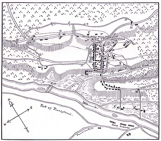
This map from Stryker's 1898 "The Battles of
Trenton and Princeton" shows the town at the time of the 1st Battle
of Trenton in 1776.
TRENTON
ONE HUNDRED YEARS AGO.
WILLIAM S. STRYKER,
ADJUTANT GENERAL OF NEW JERSEY.
PRINTED FOR PRIVATE DISTRIBUTION.
TRENTON. N. J.
1878
The following sketch of Trenton in the years 1776-77, is prepared from the statements of a few of our citizens who readily recall the men who lived here in those eventful years, from a very close search among land records, from Dr. Halls History of the Presbyterian Church, Trenton, from Mr. John 0. Raums History of the City of Trenton, and other notes furnished by him, from newspapers published in Philadelphia about that time, the Packet, Journal, Ledger and Gazette, from maps obtained from offices of record in this State, and Hessian maps from Cassel. I am greatly indebted to the late Dr. James B. Coleman, Mr. John R. Dill, Mr. John S. McCully, Judge William S. Yard, Mr. Benjamin Fish and the late Jasper S. Scudder.
In the beginning of the eighteenth century the land whereon Trenton is built appears to have been mostly Mahlon Stacys tract, bounded by Heaths land, Pettys plantation and the Beakes property.
In 1712, William Yard bought of Mahlon Stacy the property now on Greene street, south of State street to Washington street, and in depth one-half the present squares, in all about two acres. In 1714, he purchased of Andrew Heath one hundred acres, adjoining the Beakes estate, on what is now called Brunswick avenue.
In the same year, 1714, William Trent, a Philadelphia merchant, purchased a considerable tract of land here, and a village was commenced, called after him, Trents-town.
The land east of what is now Greene street and south of Front street, was called Littleworth. All the ground south of Front street and west of Greene street to the creek and the river, was called the meadows, and was low and swampy. The land lying on each side of the road to Bordentown, south of the creek, was then called Littleboro, also Kingsbury, the farm west, of that road Bloomsbury, and the village along the shore below Bloomsbury farm called Lamberton, after Thomas Lambert, whose tombstone is now to be seen in Riverview Cemetery.
Trenton, north of the creek, from the writings of Elkanah Watson, who was here several days in 1777, contained about seventy houses. I think there were about thirty dwellings south of the creek. The most of the houses were situated on two principal streets, called King, now Warren, and Queen, now Greene streets. These two streets, running nearly parallel and almost north and south, united at the upper end of the village, from which point the roads diverged to Pennington and to Maidenhead, now Lawrenceville. The latter road is now called Brunswick avenue. There were two other important streets in Trenton; one, Front street, began at Queen street, passed through the lower end of King street, and thence turned northward on what is now Willow street to the River Road; the other, running parallel to Front street, called Second, now State street, began on what is now the corner of State and Willow streets, crossed both King and Queen streets, and after passing the Presbyterian Church dwindled into a country road leading through an apple orchard to Henrys iron foundry and steel works on the creek. The Assunpink creek, a small stream fordable at many places, ran along the easterly and southerly line of the town, and emptied by two outlets into the Delaware river. Pettys run, passing through the village in about the channel it is at present, instead of flowing direct into the river made a sudden turn to the left, and passing along near where the bed of the Water Power is, entered the Assunpink a few yards from the mouth of the creek. King street did not extend below Front street, but Queen street crossed the creek by a long and narrow bridge. The present Hanover street, east of Queen street, was called Third street, and that part between King and Queen streets, which was much less than one-half its present size, was called Pinkertons alley. The street now known as Academy was called Fourth street, but was little more than a lane. Perry street did not exist. There was another alley between King and Queen streets, just north of the English Church, called Church alley. Dark lane commenced on Queen street, running easterly, about on the line of the present Feeder. There was an alley running west from King street, near where West Hanover street is, and this led off into the River Road. It was called DeCows alley. The River Road commenced from Front street, passed Second street, curved to the left nearly into what is now Quarry street and the bed of the Feeder, and after several turns came into what is now State street, about in front of the present residence of Mr. Montgomery. Queen street, crossing the creek, became the road to Bordentown and Crosswicks. A wagon road leading down what is now Market street to the Bloomsbury farm house, now the residence of Mr. E. H. Stokes, turned there and led to the ferry. The Ferry road started from what is now called the Eagle Hotel to the Trenton landing on the river Delaware.
On the Brunswick road we find the first house on the westerly side of the road occupied by William Gain, and the next was the Fox Chase Tavern, owned by Cain, whose widow afterward married Joseph Bond. She managed the establishment. Some distance further on was a shanty owned by an old colored man and beyond it the house of Thomas Selvidge. There was a lane from the junction of King and Queen streets northward, on what is now called Princeton avenue. This lane led to the house and stable of the Beakes estate. The first house on the left side of the Pennington road was that of Dr. David Cowell, a bachelor, an eminent physician and surgeon, and his brother, Ebenezer Cowell, a lawyer, lived with him. Some distance beyond, on the opposite side, Richard W. Furman resided. Opposite to what is now Calhoun street, Alexander Calhoun lived and kept a store for general merchandise, and a dwelling house and property next to him belonged to John Chambers. Abraham Cottnam lived a short distance above Calhoun, on the other side of the road. He died there in 1776, and his sons, George and Warrell, the latter a lawyer, lived there until 1779, when they sold the house to Colonel David Brearley, afterward Chief Justice of the State, who had married their sister. Richard Howell .and his son, Arthur Howell, both coopers, lived just beyond, on the north side of the roadway. Mr. Howells house was the alarm house and picket post of the Hessian troops in December, 1776. On the outskirts of the village, on the right side of the road, but some distance from it, Nathaniel Furman lived on the place now occupied by Mr. Israel Hendrickson. A lane led from opposite Alexander Calhouns house, down what is now Calhoun street, crossed the River Road about at the Feeder bridge, and ended at Beattys ferry at the head of the falls, on the river just back of the present residence of Dr. Pearson. This was undoubtedly a road much used during the last century.
Starting down King street on the westerly side we find first Isaac Brearley, then Samuel Tucker, who was President of the Provincial Congress of New Jersey in 1775, Justice of the Supreme Court in 1776, and took protection from the British while Treasurer of the State for the purpose of preserving public funds and private trusts, then in his possession. Josiah Appleton lived next, then Samuel Bellerjeau and Jacob Benjamin. Charles Axford lived about where the Feeder now crosses the street, and it was near his door that two of the Hessian cannon were captured. Next to Mr. Axford, Polly Brown kept a little shop where she sold spirits. Stacy Potts commodious frame house was opposite what is now Perry street. This was the headquarters of Colonel Rall, the Hessian commander, and the place where he died after the battle. An alley above Stacy Potts house led to his tan-yard, a large tract through which Pettys run flowed, the yard containing, as advertised, sixty-four fats. Miss Rebecca Coxe lived south of Mr. Potts, opposite the English, now St. Michaels, Church. It will be remembered that it is related as an incident of the fight that a little daughter of Mr. Potts, then in Miss Coxes house, was slightly injured while trying to reach her fathers house. Mrs. Hill lived below and sold refreshments, and then James Wilson, the silversmith, had a little shop where he worked at his trade. Under the same roof was the shop of John Fitch, then a gunsmith and maker of buttons for the American army. He was at one time apprenticed to Wilson, and afterward Wilson worked for Fitch when be had a large order for repairing arms, and employed, it is said, sixty men in the business. Fitchs shop was burned by the British. He went to Pennsylvania and afterward became the successful steamboat inventor. Thomas, Mary and Sarah Barnes lived on the ground now occupied by the Third Presbyterian Church. Mr. Barnes was a druggist, and his advertisement of salves, ointments, &c., appears in Isaac Collins Trenton Gazette. Isaac DeCow lived on the north side of DeCows alley. Colonel Isaac Smith, who commanded the regiment of militia in and about Trenton, and who was the first President of the Trenton Banking Company, a physician by profession, and at one time a Judge of the Supreme Court, lived where the American Hotel now stands. He was a man of great integrity and patriotism, and was a friend of Washington. He is always described as a very corpulent man. James B. Machetts house was opposite Pinkertons alley. Joseph Brittain, the shoemaker, lived where the United States Hotel is, and some think Mrs. Brittain kept a public house there. The celebrated Dr. Nicholas Belleville, when he settled in Trenton, in 1778, and became a partner of Dr. Bryant, boarded at the house of Mrs. Brittain. Joseph Higbees house was the next on that street, and on the northwest corner of King and Second streets was the store and residence of Abraham Hunt, the rich merchant. In his parlor he entertained Colonel Rall on the night of December 25th, 1776, and the following morning still found Rall enjoying his Christmas hospitality. On the southwest corner, where the Mechanics Bank now stands, Francis Witt kept the Blazing Star Tavern. It is evident Governor Livingston lived at this house during his residence in Trenton. It was afterward occupied by Samuel Henry, who owned the iron works, which be built in 1769, near where State street now crosses the Assunpink. Witt left the tavern in 1777, and engaged in the auction business. Archibald William Yard owned all the rest of the property to Front street, and lived in the middle of the block. Conrad Kotts occupied a little house just below Mr. Yard, but surrounded by property owned by the latter gentleman. On the opposite side of Front street lived Daniel Yard, who was an assistant to Major Peter Gordon in the Quarter Masters Department.
Beginning again at the upper part of King street and easterly side we find John Chambers lived in the house a portion of which is now the Childrens Home. William Tindall lived below him, and this house, on the digging of the Feeder, was removed to the opposite side of the street, and is now the second house north of the Feeder. William Smith, a young man of about twenty-two years of age, had a house just below Mr. Tindall. Two soldiers of the Jersey Continental Line, John Harden and Jacob Keen, were the next residents of this street. Mr. Keen was not at home on the day of the battle, being with the Jersey troops at Morristown. Mrs. Keen was, a very zealous Baptist, was one of the organizers of that church in this city, and was often called Deacon Keen . Mary and Sarah Smith occupied a small dwelling between Mr. Harden and Mr. Keen. William Patterson lived next to Keen, and John Plaskett and Richard Norris, a maker of stays, lived in the double house just above Pettys Run. Mr. Pontius Delare Stille lived in the house still standing on southeast corner of Perry street. Crossing Church alley we find the English Church, now St. Michaels Episcopal Church. This was used as a barracks by Colonel Ralls grenadier regiment. Aaron Howells blacksmith shop and his house, where Ellet Howell, who was in the Quarter Masters Department, also lived, adjoined the church. Sheriff Micajah How, of Hunterdon county, lived in what is known as the Leake property, lately torn down. George Elys house was next to Hows, then Doctor Woolseys house and office, and next to him David Pinkerton kept a general store on the corner of the alley called by his name. There was a building where the Trenton House now stands, but its owner is unknown; George Abbott, afterward occupied it. Job Moore lived adjoining, and Abraham G. Claypooles house and his office as Justice of the Peace was on the northeast corner of King and Second streets. The Post Office was on the corner below, Abraham Hunt being the Deputy Postmaster. The stone building now the Trenton Bank, was the gaol, and Peter Hulick the gaoler. A shot struck this building on the evening of January 2d, 1777. Abraham Hunt had a storehouse on the northeast corner of King and Front streets, but it is thought to have been built in somewhat later years.
Turning now to Queen street, westerly side, we find a little house occupied by an old colored man just back of William Tindalls house on King street just mentioned. William Smith, on King street, owned back of his own property to Queen street, and James Linn all the ground south of Smiths line to Pettys Run. Midway between Church alley and Pinkertons alley John Yard resided, and Benjamin Smith lived and kept a grocery and variety store on the corner below. A man by the name of Downing lived on the southwest corner of Pinkertons alley, Joseph Vandergrift in the middle of the square, and Joseph Milnor on what is now the State Gazette corner. William Tucker and Ellet Tucker lived on the southwest comer of Queen and Second streets, and this house was being plastered at the time of the cannonade of the second of January. They were both hatters and their shop was the next frame building below the corner. Joshua Newbolds blacksmith shop was on that block, and the Black Horse tavern on the Front street corner. This tavern was kept by Robert Rutherford, whose daughter, Frances Mary, eloped some six years previous with Colonel Fortescue, a British officer. Captain John Barnes lived in the old stone house, torn down lately, just below Washington Market. General Washington spent the night of Dec. 29, 1776, in this dwelling.
On Queen street, at what is now the northeast corner of Academy and Greene streets, the log church of the Methodists was situated. This was built in 1772 and remained there twenty years. Robert Lindsay and John Cooper were assigned to this circuit in May, 1776. Mr. Bonnel lived just north of the church and below it lived Joseph and Samuel Laning, with their blacksmith shop next door. Thomas Tindall built a house of brick and placed its date of erection, 1740, in black brick on its front, on the northeast corner of Queen and Third streets. An old frame stable and the house of John Bellerjeau were in the middle of the next block, and Polly Hopkins owned the present City Hall corner. There was a building on the comer below, in after years occupied by Isaac Collins, printer of the Trenton Gazette. Thomas Ryall and Joshua Newbold lived opposite Newbolds shop before mentioned.
I do not find that Pinkertons alley contained any houses other than those on the several corners. Aaron D. Woodruff nearly twenty years afterward and for the term of twenty-four years held the office of Attorney-General of the State. He lived on Third street, next to Mr. Tindalls. The Rev. Dr. Elihu Spencer, and after him the Rev. James F. Armstrong, resided in the Presbyterian parsonage on Third street, just east of Mr. Woodruffs house. There was a stable by the parsonage which was destroyed by the Hessians. The parsonage was also used by them as a hospital, and much damaged. Stephen Lowrey, who lived at Dr. Spencers, was Commissary of Issues in the Commissary Generals Department. The Friends Meeting House, at the end of the street, is still standing, although much modernized in appearance. It was built in 1739. Nearly opposite it lived Major Schuyler, a well-known colored man. Beyond the street commenced the orchard where the Hessians retreated after the surprise on the morning of December 26th, and where, they at last surrendered.
John Rickey had a house and hardware store about where Chief Justice Beasley now resides. It was a double one-story hipped-roof stone building, and built in 1752. The village school house was where the Presbyterian Church stands, and the church itself was quite near what is now the City Hall lot. Polly Yard lived on the south side of Second street, west of William Tuckers. William Roscoe, an express rider for Governor Livingston, lived in a little one-story building. The Bulls Head Tavern, kept by Henry Drake, was the largest building on the block, then Sylvester Doyles house and the Post Office before mentioned. Moore Furman, Deputy Quarter Master General of the State, had an office and resided where the State Street House is located. The alley opposite, now Sterlings alley, was called Hunts alley, Abraham Hunts stable being on the westerly corner. Polly Hawkins lived in a small house on this alley. Mr. Davies lived just west of the stable on Second street, in what was afterward called the Pike house. Major Peter Gordon, of the Quarter Master Generals Department, for .many years State Treasurer, lived nearly opposite, and Alexander Chambers residence was next door and his store on the corner of the River Road. Squire Benjamin Yard lived on the opposite corner. A lane half the width of Second street led westerly as far only as the stone house, in after years, 1793 and 94, General Knoxs war office. I have failed to find who owned it in 1776. Out on the River Road, a property now owned by Mr. Richey, Sir John Sinclair lived on his elegant seat called Bellville, and General Philemon Dickinson owned the Hermitage, a portion of which now forms the residence of Mr. Atterbury. This was the Yager picket post on that road. General Dickinson purchased this place July 30, 1776. It may be noted that this investment took place between the Declaration of Independence and the battle of Trenton, and it shows his confidence in the patriotism of the country, when he placed funds in a property which lay on the highway between two great cities, objective points for British attack. Captain John Mott, of the Jersey Continental troops, and guide to the American army at the battle of Trenton, lived some distance out of the town on property now attached to the Lunatic Asylum. The Widows Home, on Front street, was then joined with the stone house on the opposite side of the street, and this made the barracks, erected in 1756, during the French and Indian war, intended to hold about three hundred men, and used at the period of which we speak to hold refugees and soldiers of Knyphausens regiment. Stacy Potts, in 1776, built a steel works just back of the barracks on Pettys run, and Dr. Daniel W. Coxe erected a stone building for a paper mill, in 1756, near the outlet of Pettys run into the Assunpink creek.
On the northerly side of Front street, between King and Queen streets, was a small tavern called Ship and Castle, and then Samuel W. Stocktons residence near the Black Horse Tavern on the corner. Mr. Stockton was then a young man, but afterward became quite prominent in official life. Between his house and the tavern, off of the line of the street, was the village market. Mrs. Yard lived on the south side of Front street, and there was also a building near her house used as Yards bakery.
Crossing the Queen street bridge, on the east side was the site of Mahlon Stacys flour mill, built in 1680, of hewn logs, and one and one-half stories high. In 1690 William Trent purchased the property and built a stone mill there two stories high. George Bright had a two-story stone building next to the mill, which he used as a bakery. On a rough, blue sandstone, imbedded in the wall, was cut, "G. B., 1756. This stone was afterward placed in the front wall of the paper mill of Harry McCall. Mr. Bright lived on the west side of the road, opposite his bakery. Next to the bakery was Jonathan Richmonds tavern, the headquarters of General Washington for the first two days of the year 1777, but which he was obliged to abandon on the afternoon of January 2d. Samuel Wooley lived on the westerly side and Captain Alexander Douglass in what was so long known as the Douglass house, General St. Clair's headquarters, lately torn down. Jacob Garwood lived on the easterly side nearly opposite the lane leading to the Bloomsbury farm, the residence of John Cox. Miss Mary Dagworthy, who was so active in aiding, the sick and wounded soldiers, and who strewed flowers afterward on Washington's pathway at the bridge, lived and taught school where the Eagle Hotel now stands. Robert Pearson lived a short distance south of the entrance to the Ferry road.
Doctor Daniel W. Coxe, the counselor and friend of the English army, lived on the corner of the wagon road leading from Bloomsbury farm to the Ferry road. Opposite his house was a fort, built during the French and Indian war, and just beyond it Rensselaer Williams tavern. Opposite the tavern was the saddlery of Mr. B. Smith.
Below Trenton Landing, in Lamberton, I note the house of Capt. John Clunn, a mariner, in the house now occupied by James Wooley, also Hugh Runyon, a druggist, Jabez Ashmore, William Richards, a storekeeper, William Douglass and Abraham Waglum.
There are a few others who resided in Trenton, I have reason to think, at this period, but whose residence cannot now be accurately determined. Among these are Charles Clunn, William Pidgeon, Michael Thorn, Daniel Howell, William Clayton and Michael Clunn. During the war, although I believe at the latter part of it, James Burnside had a bookstore, and John Singer a dry goods store in the village. Robert Hoops lived, if not in Trenton, still near the town. Dr. William Bryant, the eminent physician, lived south of the Assunpink creek. Probably most, if not all those just named, lived in the same locality.
I trust this article, the result of notes taken at various times during many years, may interest the people of this historic city in the men who lived here one hundred years ago.
WILLLIAM S. STRYKER,
(Adjutant General of New Jersey).
Up To Top /
Home
The Society : About Us / Artifacts
Committee / Education Committee / Preservation
Committee / Membership / Contact
Us / Events
Our History : Sights & Sounds
/ 1929 History / Old
& New / Hill Diaries / Chronological
Indexes / Trenton Made / Documents / Tours
Your Ancestors : Research Services
/ Obituaries / City
Directories / High School Yearbooks /
Cemeteries / Genealogy
The City : Buildings /
Historic Districts / North
Ward Survey / Street Names / Local
Links
Search Our Site
Up
To Top / Home
The Society : Preservation
Committee / Artifacts Committee / Membership / Contact
Us / Events
Our History : Sights & Sounds / 1929
History / Old & New / Hill Diaries/ Chronological
Indexes / Trenton Made
Your Ancestors : Research Services / Obituaries / City
Directories / High School Yearbooks / Cemeteries
The City : Historic Districts / North
Ward Survey / Street Names / Local Links